File:Emilia-Romagna floods satellite.png

Original file (4,410 × 2,794 pixels, file size: 11.55 MB, MIME type: image/png)
Captions
Captions
Summary
[edit]| Description |
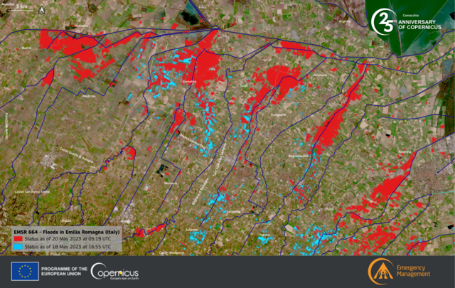
English: Emilia-Romagna, an Italian region known for its rich history and culture, is being devastated by unprecedented floods which started in mid-May 2023.
Heavy rains led to the overflow of twenty-three rivers across the region, causing widespread damage and displacing more than 30,000 residents. This catastrophic event claimed the lives of 14 people, significantly impacted nearly a million people, and resulted in an estimated €5 billion in damages. In the aftermath, the European Union swiftly responded by activating the EU Civil Protection Mechanism and mobilising aid from multiple Member States to assist Italy in its recovery efforts. The Rapid Mapping module of the Copernicus Emergency Management Service (CEMS) has produced detailed delineation maps of the flooded areas. This data visualisation, based on CEMS data, shows the extent of the flooded areas by combining the data of 18 May and 20 May. |
| Date | |
| Source | https://www.copernicus.eu/en/media/image-day-gallery/historic-floods-hit-emilia-romagna-italy |
| Author | European Union, Copernicus Emergency Management Service data |
| Other versions |
.png)
Licensing
[edit]

|
This image contains data from a satellite in the Copernicus Programme, such as Sentinel-1, Sentinel-2 or Sentinel-3. Attribution is required when using this image.
Attribution: Contains modified Copernicus Sentinel data 2023
The use of Copernicus Sentinel Data is regulated under EU law (Commission Delegated Regulation (EU) No 1159/2013 and Regulation (EU) No 377/2014). Relevant excerpts:
Free access shall be given to GMES dedicated data [...] made available through GMES dissemination platforms [...].
Access to GMES dedicated data [...] shall be given for the purpose of the following use in so far as it is lawful:
GMES dedicated data [...] may be used worldwide without limitations in time.
GMES dedicated data and GMES service information are provided to users without any express or implied warranty, including as regards quality and suitability for any purpose. |
File history
Click on a date/time to view the file as it appeared at that time.
| Date/Time | Thumbnail | Dimensions | User | Comment | |
|---|---|---|---|---|---|
| current | 14:20, 26 May 2023 | | 4,410 × 2,794 (11.55 MB) | PalauanLibertarian (talk | contribs) | Uploaded a work by European Union, Copernicus Emergency Management Service data from https://www.copernicus.eu/en/media/image-day-gallery/historic-floods-hit-emilia-romagna-italy with UploadWizard |
You cannot overwrite this file.
File usage on Commons
The following page uses this file: