File:Elam Map.jpg
Jump to navigation
Jump to search
No higher resolution available.
Elam_Map.jpg (300 × 250 pixels, file size: 28 KB, MIME type: image/jpeg)
Captions
Captions
Add a one-line explanation of what this file represents
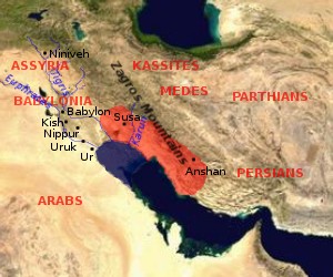
Map of Elam (approximate extension of the Elamite Empire is shown in red, the size of the Persian Gulf in the Bronze Age is indicated in blue (violet?))

|
Permission is granted to copy, distribute and/or modify this document under the terms of the GNU Free Documentation License, Version 1.2 or any later version published by the Free Software Foundation; with no Invariant Sections, no Front-Cover Texts, and no Back-Cover Texts. A copy of the license is included in the section entitled GNU Free Documentation License. |
| This file is licensed under the Creative Commons Attribution-Share Alike 3.0 Unported license. | ||
| ||
| This licensing tag was added to this file as part of the GFDL licensing update. |
by en:User:Dbachmann, based on [1] archive copy at the Wayback Machine, [2] archive copy at the Wayback Machine.


![[1]](http://www.zoroastriankids.com/map_elam.gif)
![[2]](http://home.columbus.rr.com/malyan/Resources/mesoiranmap.gif)
File history
Click on a date/time to view the file as it appeared at that time.
| Date/Time | Thumbnail | Dimensions | User | Comment | |
|---|---|---|---|---|---|
| current | 09:01, 28 July 2005 | | 300 × 250 (28 KB) | Dbachmann (talk | contribs) | update |
| 08:18, 26 July 2005 |  | 300 × 250 (23 KB) | Dbachmann (talk | contribs) | Map of Elam {{GFDL}} by en:User:Dbachmann, based on [http://www.zoroastriankids.com/map_elam.gif], [http://home.columbus.rr.com/malyan/Resources/mesoiranmap.gif]. |
You cannot overwrite this file.
File usage on Commons
The following 2 pages use this file:
File usage on other wikis
The following other wikis use this file:
- Usage on af.wikipedia.org
- Usage on am.wikipedia.org
- Usage on ar.wikipedia.org
- Usage on av.wikipedia.org
- Usage on azb.wikipedia.org
- Usage on ba.wikipedia.org
- Usage on bg.wikipedia.org
- Usage on bn.wikipedia.org
- Usage on ca.wikipedia.org
- Usage on ckb.wikipedia.org
- Usage on cv.wikipedia.org
- Usage on da.wikipedia.org
- Usage on de.wikipedia.org
- Usage on diq.wikipedia.org
- Usage on el.wikipedia.org
- Usage on en.wikipedia.org
- Usage on es.wikipedia.org
- Usage on et.wikipedia.org
- Usage on eu.wikipedia.org
- Usage on fa.wikipedia.org
- Usage on fi.wikibooks.org
- Usage on fr.wikipedia.org
- Usage on gl.wikipedia.org
- Usage on he.wikipedia.org
- Usage on hi.wikipedia.org
- Usage on hr.wikipedia.org
- Usage on hu.wikipedia.org
- Usage on hu.wikisource.org
View more global usage of this file.