File:East face of Kirtlington quarry geograph org uk.jpg
Jump to navigation
Jump to search

Size of this preview: 800 × 451 pixels. Other resolutions: 320 × 180 pixels | 640 × 361 pixels | 1,024 × 577 pixels | 1,280 × 722 pixels | 2,560 × 1,443 pixels.
Original file (2,560 × 1,443 pixels, file size: 2.54 MB, MIME type: image/jpeg)
Captions
Captions
Add a one-line explanation of what this file represents
Summary
[edit]| Description |
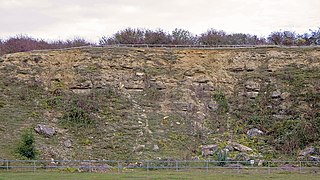
English: Eastern face of the Kirtlington Quarry (Washford Quarry), a disused limestone quarry. The sedimentary rocks exposed in this quarry bear a rich Middle Jurassic (Bathonian) fossil fauna, including terrestrial microvertebrates. The eastern face exposes marls of the Forest Marble Formation at the top (yellowish weathering rock) underlain by limestones of the White Limestone Formation (thickly bedded, darker weathering rock). The Forest Marble contains the Kirtlington Mammal Bed, the most productive microvertebrate horizon of the quarry.
Deutsch: Ostwand des Kirtlington Quarry (Washford Quarry), eines auflässigen Kalksteinbruches. Die in diesem Steinbruch aufgeschlossenen Sedimentgesteine enthalten eine reichhaltige Fossilfauna des Mittleren Jura (Bathon), einschließlich terrestrischer Mikrovertebraten. Im oberen Teil der Ostwand stehen Mergel der Forest-Marble-Formation (das gelblich verwitternde Gestein) an, unterlagert von Kalksteinen der White-Limestone-Formation (das dickbankige, dunkler verwitternde Gestein). Die Forest-Marble-Formation enthält das Kirtlington Mammal Bed („Kirtlingtoner Säugetier-Schicht“), den ergiebigsten Mikrovertebratenhorizont des Steinbruches. |
||
| Date | |||
| Source | geograph.org.uk — Main face detail: Kirtlington Quarry | ||
| Author | Dylan Moore | ||
| Permission (Reusing this file) |
|
||
| Attribution (required by the license) | Dylan Moore / Main face detail: Kirtlington Quarry / | ||

| Camera location | | View this and other nearby images on: OpenStreetMap |
|---|
_heading:67.00&language=en)
| Object location | | View this and other nearby images on: OpenStreetMap |
|---|
_heading:67.00&language=en)
Licensing
[edit]
This file is licensed under the Creative Commons Attribution-Share Alike 2.0 Generic license.
Attribution: Dylan Moore
- You are free:
- to share – to copy, distribute and transmit the work
- to remix – to adapt the work
- Under the following conditions:
- attribution – You must give appropriate credit, provide a link to the license, and indicate if changes were made. You may do so in any reasonable manner, but not in any way that suggests the licensor endorses you or your use.
- share alike – If you remix, transform, or build upon the material, you must distribute your contributions under the same or compatible license as the original.
File history
Click on a date/time to view the file as it appeared at that time.
| Date/Time | Thumbnail | Dimensions | User | Comment | |
|---|---|---|---|---|---|
| current | 13:32, 25 August 2015 | | 2,560 × 1,443 (2.54 MB) | Gretarsson (talk | contribs) | {{Information |Description ={{en|1=Eastern face of the Kirtlington Quarry (Washford Quarry), a disused limestone quarry. The sedimentary rocks exposed in this quarry bear a rich Middle Jurassic (Bathonian) fossil fauna, including terrestrial microve... |
You cannot overwrite this file.
File usage on Commons
The following page uses this file:
File usage on other wikis
The following other wikis use this file:
- Usage on de.wikipedia.org
- Usage on en.wikipedia.org
- Usage on www.wikidata.org