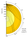
File:Earthquake wave shadow zone-es.svg
Tools
Actions
General
Print/export
In other projects
Appearance
From Wikimedia Commons, the free media repository

Size of this PNG preview of this SVG file: 379 × 509 pixels. Other resolutions: 179 × 240 pixels | 357 × 480 pixels | 572 × 768 pixels | 762 × 1,024 pixels | 1,525 × 2,048 pixels.
Original file (SVG file, nominally 379 × 509 pixels, file size: 224 KB)
File information
Structured data
Captions
Captions
Add a one-line explanation of what this file represents
| DescriptionEarthquake wave shadow zone-es.svg |
original: Raypaths of S- and P-waves through the Earth's mantle and core, SVG version based on this image from the USGS. SVG by Vanessa Ezekowitz earthquake shadows zones are the zones where seismic waves do not reach. es:Recorrido de las ondas S y P a través del manto y el núcleo terrestres. Modificado de la imagen producida en formato SVG por Vanessa Ezekowitz a partir de una imagen del U.S. Geological Survey que está en el dominio público. La zona de sombra es una zona en la que, debido a la refracción en el manto, las ondas P no alcanzan la superficie: forma una corona alrededor de las antípodas del foco sísmico (hipocentro). |
| Date | (UTC) |
| Source | Earthquake wave shadow zone.svg |
| Author |
Earthquake wave shadow zone.svg: Vanessa Ezekowitz
|
| SVG development InfoField | This W3C-invalid vector image was created with Inkscape, or with something else. |
| This is a retouched picture, which means that it has been digitally altered from its original version. Modifications: Language/Idioma. The original can be viewed here: Earthquake wave shadow zone.svg:
|
I, the copyright holder of this work, hereby publish it under the following license:
This file is licensed under the Creative Commons Attribution-Share Alike 3.0 Unported license.
- You are free:
- to share – to copy, distribute and transmit the work
- to remix – to adapt the work
- Under the following conditions:
- attribution – You must give appropriate credit, provide a link to the license, and indicate if changes were made. You may do so in any reasonable manner, but not in any way that suggests the licensor endorses you or your use.
- share alike – If you remix, transform, or build upon the material, you must distribute your contributions under the same or compatible license as the original.
Original upload log
[edit]This image is a derivative work of the following images:
- File:Earthquake_wave_shadow_zone.svg licensed with Cc-by-sa-3.0
- 2008-08-08T22:21:27Z Vanessaezekowitz 379x509 (229262 Bytes) Raypaths of S- and P-waves through the Earth's mantle and core, SVG version based on [http://earthquake.usgs.gov/learning/glossary.php?term=shadow zone this image] from the USGS. SVG by Vanessa Ezekowitz
Uploaded with derivativeFX
File history
Click on a date/time to view the file as it appeared at that time.
| Date/Time | Thumbnail | Dimensions | User | Comment | |
|---|---|---|---|---|---|
| current | 18:51, 10 November 2010 |  | 379 × 509 (224 KB) | Luis Fernández García (talk | contribs) | Reeditado con Inkscape para Mac OS X. Versión anterior con proporciones deformadas. |
| 16:06, 10 November 2010 |  | 512 × 512 (52 KB) | Luis Fernández García (talk | contribs) | {{Information |Description===original: Raypaths of S- and P-waves through the Earth's mantle and core, SVG version based on this image from the USGS. SVG by Vanessa Ezekowitz earthquake shadows zones are the zones where seismic waves do not reach. es:Rec |
You cannot overwrite this file.
File usage on Commons
There are no pages that use this file.
