File:EUROPE 1929-1938 POLITICAL MAP.svg
Jump to navigation
Jump to search

Size of this PNG preview of this SVG file: 650 × 600 pixels. Other resolutions: 260 × 240 pixels | 520 × 480 pixels | 832 × 768 pixels | 1,110 × 1,024 pixels | 2,220 × 2,048 pixels | 827 × 763 pixels.
Original file (SVG file, nominally 827 × 763 pixels, file size: 642 KB)
Captions
Captions
Add a one-line explanation of what this file represents
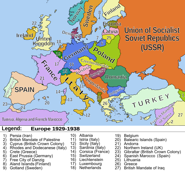
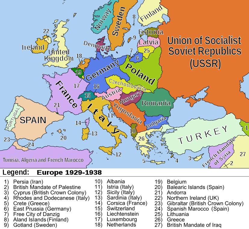
| Description | Political map of Europe between 1929 and 1938 |
| Date | (UTC) |
| Source | |
| Author |
|
| This is a retouched picture, which means that it has been digitally altered from its original version. Modifications: vector version, minor corrections. The original can be viewed here: EUROPE 1919-1929 POLITICAL 01.png:
|
I, the copyright holder of this work, hereby publish it under the following licenses:
This file is licensed under the Creative Commons Attribution-Share Alike 2.5 Generic, 2.0 Generic and 1.0 Generic license.
- You are free:
- to share – to copy, distribute and transmit the work
- to remix – to adapt the work
- Under the following conditions:
- attribution – You must give appropriate credit, provide a link to the license, and indicate if changes were made. You may do so in any reasonable manner, but not in any way that suggests the licensor endorses you or your use.
- share alike – If you remix, transform, or build upon the material, you must distribute your contributions under the same or compatible license as the original.
| This file is licensed under the Creative Commons Attribution-Share Alike 3.0 Unported license. | ||
| ||
| This licensing tag was added to this file as part of the GFDL licensing update. |

|
Permission is granted to copy, distribute and/or modify this document under the terms of the GNU Free Documentation License, Version 1.2 or any later version published by the Free Software Foundation; with no Invariant Sections, no Front-Cover Texts, and no Back-Cover Texts. A copy of the license is included in the section entitled GNU Free Documentation License. |
You may select the license of your choice.
Original upload log
[edit]
This image is a derivative work of the following images:
- File:EUROPE_1919-1929_POLITICAL_01.png licensed with Cc-by-sa-2.5,2.0,1.0, Cc-by-sa-3.0-migrated, GFDL
- 2010-01-25T21:19:05Z Ras67 827x763 (116443 Bytes) removed borders with PSP
- 2009-04-11T23:37:23Z Hohum 857x800 (119305 Bytes) Toned down bright colours.
- 2008-02-29T07:53:27Z Hoshie 857x800 (98322 Bytes) fixed the legend
- 2006-12-27T19:34:48Z JanhumpoliK 857x800 (115852 Bytes) {{Information |Description=Political map of Europe between the years 1929 and 1939 |Source=own work |Date=December 27, 2006 |Author=Jan Humpolík |Permission=GNU |other_versions=N/A }}
Uploaded with derivativeFX
File history
Click on a date/time to view the file as it appeared at that time.
| Date/Time | Thumbnail | Dimensions | User | Comment | |
|---|---|---|---|---|---|
| current | 00:03, 24 January 2011 | | 827 × 763 (642 KB) | Ras67 (talk | contribs) | borders and watermark removed, minor improvements |
| 16:47, 22 January 2011 |  | 827 × 763 (643 KB) | Alokasta~commonswiki (talk | contribs) | {{Information |Description=Political map of Europe between 1929 and 1938 |Source=*File:EUROPE_1919-1929_POLITICAL_01.png |Date=2011-01-22 16:43 (UTC) |Author=*File:EUROPE_1919-1929_POLITICAL_01.png: Jan Humpolík *derivative work: ~~~ |Permiss |
You cannot overwrite this file.
File usage on Commons
The following page uses this file:
File usage on other wikis
The following other wikis use this file:
- Usage on ar.wikipedia.org
- Usage on be.wikipedia.org
- Usage on de.wikipedia.org
- Usage on nl.wikipedia.org
- Usage on no.wikipedia.org
- Usage on zh-yue.wikipedia.org
- Usage on zh.wikipedia.org