File:Durham (Ilustrated historical atlas of Pictou County, Nova Scotia, 1879).png
Jump to navigation
Jump to search

Size of this preview: 800 × 362 pixels. Other resolutions: 320 × 145 pixels | 640 × 289 pixels | 1,024 × 463 pixels | 1,280 × 578 pixels | 4,149 × 1,875 pixels.
Original file (4,149 × 1,875 pixels, file size: 22.29 MB, MIME type: image/png)
Captions
Captions
Add a one-line explanation of what this file represents
Summary
[edit].png&action=edit§ion=1)
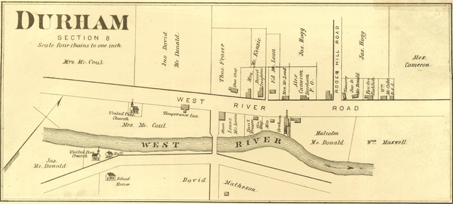
| Description | Plan of en:Durham, Nova Scotia |
| Date | |
| Source | Ilustrated historical atlas of Pictou County, Nova Scotia, created by J.H. Meacham and Company, 1879 |
| Author | J.M. Meacham |
Licensing
[edit].png&action=edit§ion=2)
|
This work is in the public domain in its country of origin and other countries and areas where the copyright term is the author's life plus 70 years or fewer. | |
| This file has been identified as being free of known restrictions under copyright law, including all related and neighboring rights. | |
File history
Click on a date/time to view the file as it appeared at that time.
| Date/Time | Thumbnail | Dimensions | User | Comment | |
|---|---|---|---|---|---|
| current | 14:57, 3 April 2021 | | 4,149 × 1,875 (22.29 MB) | Paelius (talk | contribs) | {{Information |Description=Plan of en:Durham, Nova Scotia |Source=''[https://www.novastory.ca/digital/collection/picmaps/id/102/rec/1 Ilustrated historical atlas of Pictou County, Nova Scotia]'', created by J.H. Meacham and Company, 1879 |Date=1879 |Author=J.M. Meacham }} Category:Nova Scotia in the 1870s |
You cannot overwrite this file.
File usage on Commons
There are no pages that use this file.
File usage on other wikis
The following other wikis use this file:
- Usage on pl.wikipedia.org
.png&oldid=697884041)