File:Dunford Bridge railway station (site), Yorkshire, 1981 (geograph 6890104).jpg
From Wikimedia Commons, the free media repository
Jump to navigation
Jump to search

Size of this preview: 800 × 534 pixels. Other resolutions: 320 × 213 pixels | 640 × 427 pixels | 1,024 × 683 pixels.
Original file (1,024 × 683 pixels, file size: 220 KB, MIME type: image/jpeg)
File information
Structured data
Captions
Captions
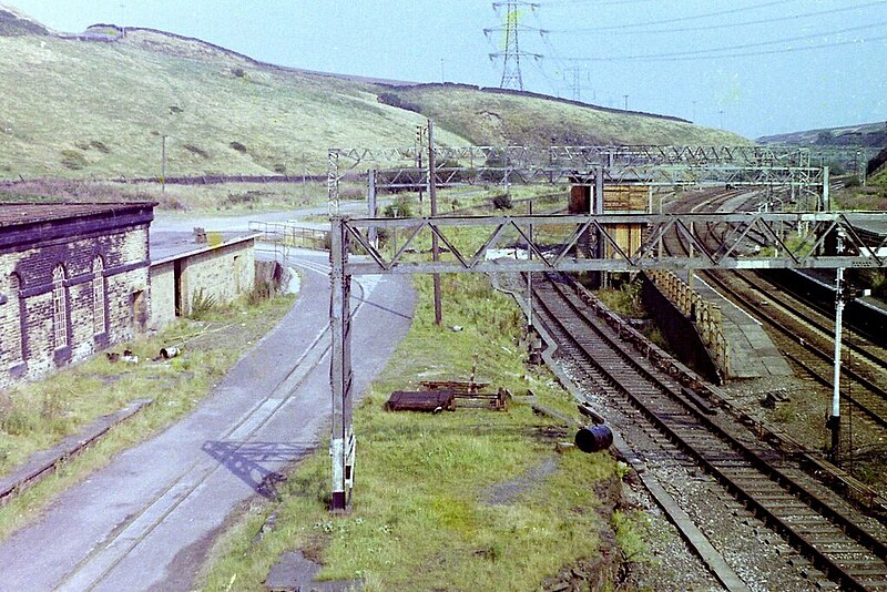
Dunford Bridge railway station (site), Yorkshire, 1981
Summary
[edit]| DescriptionDunford Bridge railway station (site), Yorkshire, 1981 (geograph 6890104).jpg |
English: Dunford Bridge railway station (site), Yorkshire, 1981 The first Dunford Bridge station (1845-1953) was at the exit from the original Woodhead tunnel, located just below and left of the camera position. Far left, still visible, was the Sheffield-bound platform. The Manchester-bound platform was directly underneath the camera position, where the grass is. When the new Woodhead tunnel opened, the line was shifted over to the right. The two short platforms of the replacement station (1953-1970) were still extant when this image was taken, 11 years after the last regular passengers had used them. One bore of the original tunnel carried National Grid high tension power lines at the time of this image. A 2' gauge railway (left) was used to take workers and materials into the tunnel. Compare with SE1502 : Dunford Bridge railway station (site), Yorkshire, 2011 taken 30 years later - the only clear reference point is the narrow gauge railway! |
| Date | |
| Source | From geograph.org.uk |
| Author | Nigel Thompson |
| Permission (Reusing this file) |
Creative Commons Attribution Share-alike license 2.0 |
| Attribution (required by the license) InfoField | Nigel Thompson / Dunford Bridge railway station (site), Yorkshire, 1981 / |
InfoField | Nigel Thompson / Dunford Bridge railway station (site), Yorkshire, 1981 |
| Camera location | 53° 31′ 03″ N, 1° 45′ 50″ W | View this and other nearby images on: OpenStreetMap |
|---|
| Object location | 53° 31′ 04″ N, 1° 45′ 45″ W | View this and other nearby images on: OpenStreetMap |
|---|
Licensing
[edit]
|
This image was taken from the Geograph project collection. See this photograph's page on the Geograph website for the photographer's contact details. The copyright on this image is owned by Nigel Thompson and is licensed for reuse under the Creative Commons Attribution-ShareAlike 2.0 license.
|
This file is licensed under the Creative Commons Attribution-Share Alike 2.0 Generic license.
Attribution: Nigel Thompson
- You are free:
- to share – to copy, distribute and transmit the work
- to remix – to adapt the work
- Under the following conditions:
- attribution – You must give appropriate credit, provide a link to the license, and indicate if changes were made. You may do so in any reasonable manner, but not in any way that suggests the licensor endorses you or your use.
- share alike – If you remix, transform, or build upon the material, you must distribute your contributions under the same or compatible license as the original.
File history
Click on a date/time to view the file as it appeared at that time.
| Date/Time | Thumbnail | Dimensions | User | Comment | |
|---|---|---|---|---|---|
| current | 20:16, 14 November 2021 |  | 1,024 × 683 (220 KB) | Lamberhurst (talk | contribs) | == {{int:filedesc}} == {{Information |Description={{en|1=<b>Dunford Bridge railway station (site), Yorkshire, 1981</b><br>The first Dunford Bridge station (1845-1953) was at the exit from the original Woodhead tunnel, located just below and left of the camera position. Far left, still visible, was the Sheffield-bound platform. The Manchester-bound platform was directly underneath the camera position, where the grass is. When the new Woodhead tunnel opened, the line was shifted over to the rig... |
You cannot overwrite this file.
File usage on Commons
The following page uses this file: