File:Dual land use^^^ Little Rollright - geograph.org.uk - 213198.jpg
From Wikimedia Commons, the free media repository
Jump to navigation
Jump to search
Size of this preview: 450 × 600 pixels. Other resolutions: 180 × 240 pixels | 480 × 640 pixels.
Original file (480 × 640 pixels, file size: 162 KB, MIME type: image/jpeg)
File information
Structured data
Captions
Summary
[edit]DescriptionDual land use^^^ Little Rollright - geograph.org.uk - 213198.jpg |
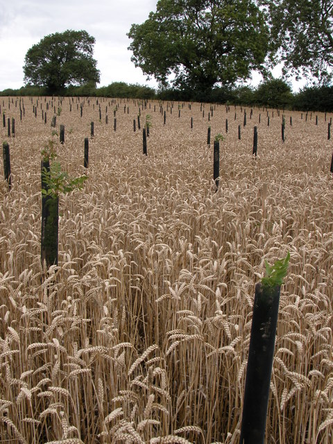
English: Dual land use??? Little Rollright. The corner of this field has a wheat crop due for harvesting in the next few days and sapling trees planted in the wheat. I assume the trees were planted after the wheat? How will they harvest the wheat? Obviously not with a combine harvester. Any ideas? |
||
Date | |||
Source | geograph.org.uk | ||
Author | Philip Halling | ||
Permission (Reusing this file) |
This file is licensed under the Creative Commons Attribution-Share Alike 2.0 Generic license. Attribution: Philip Halling
|
||
Attribution (required by the license) InfoField | Philip Halling / Dual land use??? Little Rollright / | ||
InfoField | Philip Halling / Dual land use??? Little Rollright |
Object location | 51° 58′ 21″ N, 1° 34′ 05″ W | View this and other nearby images on: OpenStreetMap | 51.972600; -1.568000 |
---|
File history
Click on a date/time to view the file as it appeared at that time.
Date/Time | Thumbnail | Dimensions | User | Comment | |
---|---|---|---|---|---|
current | 21:11, 31 January 2010 | 480 × 640 (162 KB) | GeographBot (talk | contribs) | == {{int:filedesc}} == {{Information |description={{en|1=Dual land use??? Little Rollright. The corner of this field has a wheat crop due for harvesting in the next few days and sapling trees planted in the wheat. I assume the trees were planted after the |
You cannot overwrite this file.
File usage on Commons
There are no pages that use this file.
File usage on other wikis
The following other wikis use this file:
- Usage on hy.wikipedia.org
Metadata
This file contains additional information such as Exif metadata which may have been added by the digital camera, scanner, or software program used to create or digitize it. If the file has been modified from its original state, some details such as the timestamp may not fully reflect those of the original file. The timestamp is only as accurate as the clock in the camera, and it may be completely wrong.
Camera manufacturer | NIKON |
---|---|
Camera model | E5700 |
Exposure time | 227,583/50,000,000 sec (0.00455166) |
F-number | f/5.6 |
ISO speed rating | 100 |
Date and time of data generation | 12:18, 1 August 2006 |
Lens focal length | 8.9 mm |
Orientation | Normal |
Horizontal resolution | 300 dpi |
Vertical resolution | 300 dpi |
Software used | Nikon Browser 6.1.0 W |
File change date and time | 21:32, 1 August 2006 |
Y and C positioning | Centered |
Exposure Program | Normal program |
Exif version | 2.2 |
Date and time of digitizing | 12:18, 1 August 2006 |
APEX exposure bias | 0 |
Maximum land aperture | 3 APEX (f/2.83) |
Metering mode | Pattern |
Light source | Unknown |
Flash | Flash did not fire, compulsory flash suppression |
Color space | sRGB |
Custom image processing | Normal process |
Exposure mode | Auto exposure |
White balance | Auto white balance |
Digital zoom ratio | 0 |
Focal length in 35 mm film | 35 mm |
Scene capture type | Standard |
Contrast | Normal |
Saturation | Normal |
Sharpness | Normal |
Subject distance range | Unknown |
Structured data
Items portrayed in this file
depicts
some value
1 August 2006
51°58'21.4"N, 1°34'4.8"W
0.00455166 second
5.6
8.9 millimetre
100
image/jpeg
Hidden categories:
- CC-BY-SA-2.0
- Images from Geograph Britain and Ireland
- Images from Geograph Britain and Ireland missing SDC coordinates of the point of view
- Images from Geograph Britain and Ireland missing SDC location of creation
- Information field template with formatting
- Files with coordinates missing SDC location of creation (51° N, 2° W)
- Images by Philip Halling
- United Kingdom photographs taken on 2006-08-01