File:Drawehn.png
Jump to navigation
Jump to search
Size of this preview: 511 × 599 pixels. Other resolutions: 205 × 240 pixels | 409 × 480 pixels | 775 × 909 pixels.
Original file (775 × 909 pixels, file size: 76 KB, MIME type: image/png)
Captions
Captions
Add a one-line explanation of what this file represents
| Description |
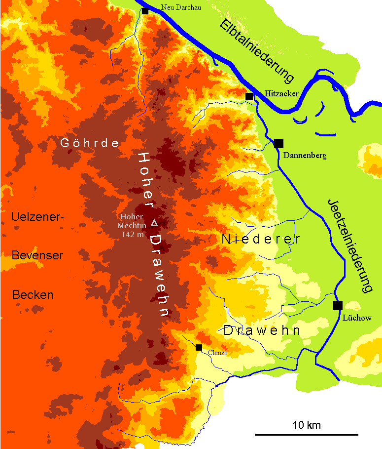
English: Map of the hilly region "Drawehn" between Hamburg and Berlin (North German Lowland). Map has a German inscription.
Deutsch: Karte des Drawehn mit Hervorhebung von Höhenschichten (geomorphologisches Profil). Die hellgrüne Farbe z. B. markiert Bereiche unter 20 m NN, orange-rot Bereiche zwischen 50 und 75 m, dunkelbraun über 100 m NN. Nur niedersächsische Gebiete sind dargestellt.
< 20 m NN
50–75 m NN
> 100 m NN |
| Date | |
| Source | Own work. |
| Author | Christian Fischer |
This file is licensed under the Creative Commons Attribution-Share Alike 3.0 Unported license.
Attribution: Christian Fischer
- You are free:
- to share – to copy, distribute and transmit the work
- to remix – to adapt the work
- Under the following conditions:
- attribution – You must give appropriate credit, provide a link to the license, and indicate if changes were made. You may do so in any reasonable manner, but not in any way that suggests the licensor endorses you or your use.
- share alike – If you remix, transform, or build upon the material, you must distribute your contributions under the same or compatible license as the original.
File history
Click on a date/time to view the file as it appeared at that time.
| Date/Time | Thumbnail | Dimensions | User | Comment | |
|---|---|---|---|---|---|
| current | 20:11, 30 August 2007 | | 775 × 909 (76 KB) | Fice (talk | contribs) | {{Information| |Description= '''''English:''''' Map of the hilly region "Drawehn" between Hamburg and Berlin (North German Lowland). Map has a German inscription. '''''Deutsch:''''' Karte des Drawehn mit Hervorhebung von Höhenschichten (geomorpholog |
You cannot overwrite this file.
File usage on Commons
The following 2 pages use this file:
File usage on other wikis
The following other wikis use this file:
- Usage on bg.wikipedia.org
- Usage on cs.wikipedia.org
- Usage on de.wikipedia.org
- Usage on en.wikipedia.org
- Usage on et.wikipedia.org
- Usage on hsb.wikipedia.org
- Usage on nl.wikipedia.org
- Usage on pl.wikipedia.org
- Usage on uk.wikipedia.org