File:Dokdo Map Ko.PNG
From Wikimedia Commons, the free media repository
Jump to navigation
Jump to search

Size of this preview: 657 × 600 pixels. Other resolutions: 263 × 240 pixels | 526 × 480 pixels | 748 × 683 pixels.
Original file (748 × 683 pixels, file size: 70 KB, MIME type: image/png)
File information
Structured data
Captions
Captions
Add a one-line explanation of what this file represents
Summary
[edit]| DescriptionDokdo Map Ko.PNG |
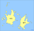
한국어: 독도 지도. 영어판에서 가져왔습니다. (인터위키를 참조하세요, 한국어로 표기하기 위해 사용된 폰트는 한겨례결체입니다.) |
|||
| Date | ||||
| Source | File:Dokdo Map.png | |||
| Author | ko:사:파란로봇군 | |||
| Permission (Reusing this file) |
아래 참고 | |||
| Other versions |
|
Licensing
[edit]
|
Permission is granted to copy, distribute and/or modify this document under the terms of the GNU Free Documentation License, Version 1.2 or any later version published by the Free Software Foundation; with no Invariant Sections, no Front-Cover Texts, and no Back-Cover Texts. A copy of the license is included in the section entitled GNU Free Documentation License.http://www.gnu.org/copyleft/fdl.htmlGFDLGNU Free Documentation Licensetruetrue |
| This file is licensed under the Creative Commons Attribution-Share Alike 3.0 Unported license. | ||
| ||
| This licensing tag was added to this file as part of the GFDL licensing update.http://creativecommons.org/licenses/by-sa/3.0/CC BY-SA 3.0Creative Commons Attribution-Share Alike 3.0truetrue |
File history
Click on a date/time to view the file as it appeared at that time.
| Date/Time | Thumbnail | Dimensions | User | Comment | |
|---|---|---|---|---|---|
| current | 01:44, 8 March 2008 |  | 748 × 683 (70 KB) | ITurtle (talk | contribs) | 워터마크 제거 |
| 07:34, 28 September 2006 |  | 748 × 683 (70 KB) | 파란로봇군 (talk | contribs) | 독도 지도. 영어판에서 가져왔습니다. 인터위키를 참조하세요. 한국어로 표기하기 위해 사용된 글꼴은 한겨례결체입니다. en:Dokdo Map.png |
You cannot overwrite this file.
File usage on Commons
There are no pages that use this file.
File usage on other wikis
The following other wikis use this file:
- Usage on ko.wikipedia.org
