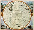
File:Detail of 1657 map Polus Antarcticus by Jan Janssonius, showing Nova Zeelandia.png
Detail_of_1657_map_Polus_Antarcticus_by_Jan_Janssonius,_showing_Nova_Zeelandia.png (684 × 532 pixels, file size: 508 KB, MIME type: image/png)
Captions
Captions
Summary
[edit]| DescriptionDetail of 1657 map Polus Antarcticus by Jan Janssonius, showing Nova Zeelandia.png |
English: Detail of 1657 map Polus Antarcticus by Jan Janssonius, showing western coastline of New Zealand (labelled "Nova Zeelandia"). |
|||||||||||||||||||||||||
| Date | ||||||||||||||||||||||||||
| Source | 1657 map Polus Antarcticus by Jan Janssonius (1588-1664). Copied from https://resolver.kb.nl/resolve?urn=urn:gvn:KONB01:447 | |||||||||||||||||||||||||
| Author |
creator QS:P170,Q949492 |
|||||||||||||||||||||||||
| Other versions |
Full map: |
|||||||||||||||||||||||||
This digital media file - and/or the physical objects depicted on it - originates from the digital and/or physical collections of the Koninklijke Bibliotheek, national library of the Netherlands.
Deutsch | English | français | македонски | Nederlands | українська | +/− |
Licensing
[edit]| Public domainPublic domainfalsefalse |
|
This work is in the public domain in its country of origin and other countries and areas where the copyright term is the author's life plus 100 years or fewer. This work is in the public domain in the United States because it was published (or registered with the U.S. Copyright Office) before January 1, 1929. | |
| This file has been identified as being free of known restrictions under copyright law, including all related and neighboring rights. | |
https://creativecommons.org/publicdomain/mark/1.0/PDMCreative Commons Public Domain Mark 1.0falsefalse
File history
Click on a date/time to view the file as it appeared at that time.
| Date/Time | Thumbnail | Dimensions | User | Comment | |
|---|---|---|---|---|---|
| current | 11:22, 25 January 2011 |  | 684 × 532 (508 KB) | Avenue (talk | contribs) | Higher resolution, stronger lines of latitude and longitude, different colours. |
| 13:14, 16 January 2010 |  | 229 × 183 (62 KB) | Avenue (talk | contribs) | {{Information |Description={{en|1=Detail of 1657 map ''Polus Antarcticus'' by Jan Janssonius, showing western coastline of New Zealand (labelled "Nova Zeelandia").}} |Source=1657 map ''Polus Antarcticus'' by Jan Janssonius (1588-1664). Copied from http:// |
You cannot overwrite this file.
File usage on Commons
There are no pages that use this file.
File usage on other wikis
The following other wikis use this file:
- Usage on af.wikipedia.org
- Usage on ar.wikipedia.org
- Usage on bn.wikipedia.org
- Usage on cbk-zam.wikipedia.org
- Usage on cs.wikipedia.org
- Usage on cy.wikipedia.org
- Usage on en.wikipedia.org
- Usage on es.wikipedia.org
- Usage on gl.wikipedia.org
- Usage on id.wikipedia.org
- Usage on incubator.wikimedia.org
- Usage on io.wikipedia.org
- Usage on is.wikipedia.org
- Usage on ka.wikipedia.org
- Usage on ko.wikipedia.org
- Usage on mk.wikipedia.org
- Usage on mt.wikipedia.org
- Usage on nl.wikipedia.org
- Usage on nn.wikipedia.org
- Usage on pa.wikipedia.org
- Usage on pt.wikipedia.org
- Usage on ru.wikipedia.org
- Usage on sh.wikipedia.org
- Usage on sl.wikipedia.org
- Usage on sr.wikipedia.org
- Usage on ta.wikipedia.org
- Usage on tr.wikipedia.org
- Usage on uz.wikipedia.org
- Usage on vi.wikipedia.org


