File:DerwitzSpitzerBerg.jpg
DerwitzSpitzerBerg.jpg (800 × 560 pixels, file size: 290 KB, MIME type: image/jpeg)
Captions
Captions
Summary
[edit]| DescriptionDerwitzSpitzerBerg.jpg |
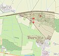
Deutsch: „Spitzer Berg“ bei Derwitz. Der Berg wurde von 1904 bis 1906 abgetragen. Die Überlagerung des OpenStreetMap Kartenausschnitts Krielow, Derwitz (Stand 2023) mit einem Kartenzitats der Karte Gr. Kreutz, Sheet 3542, Army Map Service 1945 rekonstruiert die Lage des „Spitzen Bergs“ und die Abbruchkante einer Sandgrube an seinem Nordwesthang. Otto Lilienthal nutzte 1891 für seine Gleitflüge mit dem Derwitzer Apparat die Abbruchkante einer Sandgrube am Nordwesthang des „Spitzen Bergs“ bei Derwitz als Flugplatz „F“. In einer Scheune auf dem Hof „H“ des Müllers Hermann Schwach, der eine Windmühle „W“ betrieb, stellte er den Gleiter unter. Quelle: Dachner, Hans-Georg (23 August 2015) "Otto Lilienthals erste Flugversuche in Derwitz/Krielow" in Heimatkundliche Blätter, Heft 41, Juli/August, Brandenburg an der Havel: Publikation des Arbeitskreises Stadtgeschichte im Brandenburgischen Kulturbund e. V., pp. 10−20 |
| Date | |
| Source | http://www.openstreetmap.org/ |
| Author | OpenStreetMap und Mitwirkende |
| Permission (Reusing this file) |
© OpenStreetMap und Mitwirkende, CC BY-SA 2.0 |
Licensing
[edit]- You are free:
- to share – to copy, distribute and transmit the work
- to remix – to adapt the work
- Under the following conditions:
- attribution – You must give appropriate credit, provide a link to the license, and indicate if changes were made. You may do so in any reasonable manner, but not in any way that suggests the licensor endorses you or your use.
- share alike – If you remix, transform, or build upon the material, you must distribute your contributions under the same or compatible license as the original.
| Public domainPublic domainfalsefalse |
|
This work is in the public domain in its country of origin and other countries and areas where the copyright term is the author's life plus 70 years or fewer. Note that a few countries have copyright terms longer than 70 years: Mexico has 100 years, Jamaica has 95 years, Colombia has 80 years, and Guatemala and Samoa have 75 years. This image may not be in the public domain in these countries, which moreover do not implement the rule of the shorter term. Honduras has a general copyright term of 75 years, but it does implement the rule of the shorter term. Copyright may extend on works created by French who died for France in World War II (more information), Russians who served in the Eastern Front of World War II (known as the Great Patriotic War in Russia) and posthumously rehabilitated victims of Soviet repressions (more information).
| |
| This file has been identified as being free of known restrictions under copyright law, including all related and neighboring rights. | |
https://creativecommons.org/publicdomain/mark/1.0/PDMCreative Commons Public Domain Mark 1.0falsefalse
File history
Click on a date/time to view the file as it appeared at that time.
| Date/Time | Thumbnail | Dimensions | User | Comment | |
|---|---|---|---|---|---|
| current | 17:40, 5 May 2023 |  | 800 × 560 (290 KB) | Michael32710 (talk | contribs) | cropped |
| 15:53, 5 May 2023 |  | 800 × 760 (364 KB) | Michael32710 (talk | contribs) | transparency increased | |
| 08:39, 3 May 2023 |  | 800 × 760 (362 KB) | Michael32710 (talk | contribs) | Overlay with old map more filigree | |
| 13:23, 2 May 2023 |  | 800 × 760 (428 KB) | Michael32710 (talk | contribs) | == {{int:filedesc}} == {{Information |Description ={{de|1=OpenStreetMap Kartenausschnitt Krielow, Derwitz. Lage des ''Spitzen Berges'' anhand eines Kartenzitats der Karte ''Gr. Kreutz, Sheet 3542, Army Map Service 1945''.<br />Örtlichkeiten von Otto Lilienthals Gleitflügen 1891: "H" Hof des Müllers, "W" Windmühle, "S" Kuppe des Spitzen Bergs, "F" Flugplatz an der Abbruchkante der Sandgrube}} |Source =http://www.openstreetmap.org/ |Author =OpenStreetMap und Mitwirkende |Date... |
You cannot overwrite this file.
File usage on Commons
There are no pages that use this file.
File usage on other wikis
The following other wikis use this file:
- Usage on de.wikipedia.org
Metadata
This file contains additional information such as Exif metadata which may have been added by the digital camera, scanner, or software program used to create or digitize it. If the file has been modified from its original state, some details such as the timestamp may not fully reflect those of the original file. The timestamp is only as accurate as the clock in the camera, and it may be completely wrong.
| Orientation | Normal |
|---|---|
| Horizontal resolution | 72 dpi |
| Vertical resolution | 72 dpi |
| Software used | Adobe Photoshop Elements 15.0 (Windows) |
| File change date and time | 19:38, 5 May 2023 |
| Color space | sRGB |
| Date and time of digitizing | 20:27, 30 April 2023 |
| Date metadata was last modified | 21:38, 5 May 2023 |
| Unique ID of original document | xmp.did:d130de39-0b82-fe40-bd29-aca25086c1b7 |
