File:Dekenij zele.jpg
Jump to navigation
Jump to search

Size of this preview: 800 × 577 pixels. Other resolutions: 320 × 231 pixels | 640 × 462 pixels | 1,024 × 739 pixels.
Original file (1,024 × 739 pixels, file size: 457 KB, MIME type: image/jpeg)
Captions
Captions
Add a one-line explanation of what this file represents
Summary
[edit]
| Description |
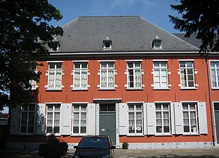
Nederlands: In 1737 werd ten noorden van de Sint-Ludgeruskerk in Zele een pastorie opgetrokken. De ontvangstkamer werd omstreeks 1740 bekleed met Mechels goudleer, met een voorstelling van florale motieven en ranken. In 1910 werd Zele een dekenij. Het dekenijgebouw werd in 1997 beschermd als monument. De omgeving van de dekenij vormt een beschermd dorpsgezicht.
|
||
| Date | |||
| Source | Own work | ||
| Author | Zoetj |
| Camera location | | View this and other nearby images on: OpenStreetMap |
|---|
Licensing
[edit]
I, the copyright holder of this work, hereby publish it under the following license:
This file is licensed under the Creative Commons Attribution-Share Alike 3.0 Unported license.
- You are free:
- to share – to copy, distribute and transmit the work
- to remix – to adapt the work
- Under the following conditions:
- attribution – You must give appropriate credit, provide a link to the license, and indicate if changes were made. You may do so in any reasonable manner, but not in any way that suggests the licensor endorses you or your use.
- share alike – If you remix, transform, or build upon the material, you must distribute your contributions under the same or compatible license as the original.

|
This image was uploaded as part of Wiki Loves Monuments 2013.
|
 |
File history
Click on a date/time to view the file as it appeared at that time.
| Date/Time | Thumbnail | Dimensions | User | Comment | |
|---|---|---|---|---|---|
| current | 20:15, 7 September 2013 | | 1,024 × 739 (457 KB) | Zoetj (talk | contribs) | User created page with UploadWizard |
You cannot overwrite this file.
File usage on Commons
There are no pages that use this file.
File usage on other wikis
The following other wikis use this file:
- Usage on nl.wikipedia.org
- Usage on war.wikipedia.org