File:Coral Spot Fungus (Nectria cinnabarina) - geograph.org.uk - 1091903.jpg
Original file (480 × 640 pixels, file size: 103 KB, MIME type: image/jpeg)
Captions
Captions
Summary
[edit]_-_geograph.org.uk_-_1091903.jpg&action=edit§ion=1)
| Description |
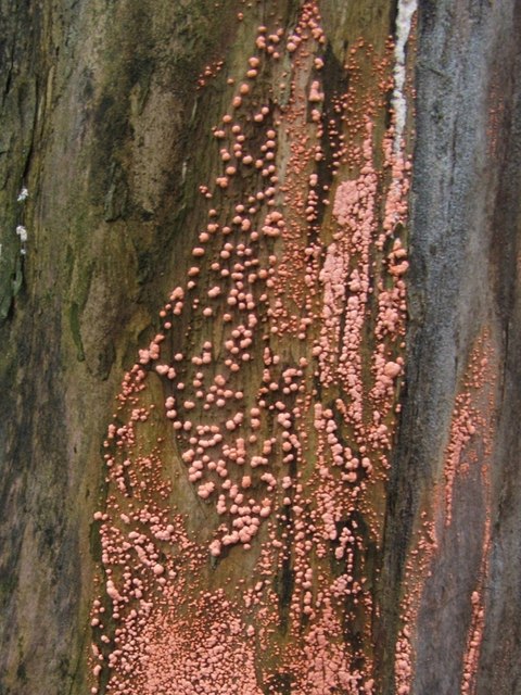
English: Coral Spot Fungus (Nectria cinnabarina). At the place where this picture was taken, there is a line of tree stumps on the pavement; the fungi shown here were growing on the side of one of them.
This dense covering of pustules is an example of the so-called "conidial stage" of the fungus Nectria cinnabarina; its coral-pink colour explains the common name of Coral Spot Fungus. This fungus occurs in dense groups on dead or dying wood - the twigs and branches of (usually) broad-leaved trees - and causes Coral-spot Disease; however, it is not a particularly strong parasite in itself, and its presence on a living plant probably indicates that its host was not in the best of condition to start with. Another commonly-encountered phase of its life-cycle, the so-called "perithecial stage", is shown on the right-hand side of the following photo: 1018737. As with many similar fungal species, it was not realized at first that the two phases were really the same species, and they were originally assigned different scientific names (in this case, the pink conidial stage was named Tuberculina vulgaris). When subsequent research reveals them to be merely two different stages of the same species, one of the two assigned names has to be discarded. |
| Date | |
| Source | From geograph.org.uk |
| Author | Lairich Rig |
| Attribution (required by the license) | Lairich Rig / Coral Spot Fungus (Nectria cinnabarina) / |
_-_geograph.org.uk_-_1018737.jpg)
| Camera location | | View this and other nearby images on: OpenStreetMap |
|---|
_-_geograph.org.uk_-_1091903.jpg¶ms=055.970410_N_-004.584900_E_globe:Earth_type:camera_source:geograph-osgb36(NS38777828)_heading:180.00&language=en)
| Object location | | View this and other nearby images on: OpenStreetMap |
|---|
_-_geograph.org.uk_-_1091903.jpg¶ms=055.970410_N_-004.584900_E_globe:Earth_class:object_type:object_source:geograph-osgb36(NS38777828)_heading:180.00&language=en)
Licensing
[edit]_-_geograph.org.uk_-_1091903.jpg&action=edit§ion=2)

|
This image was taken from the Geograph project collection. See this photograph's page on the Geograph website for the photographer's contact details. The copyright on this image is owned by Lairich Rig and is licensed for reuse under the Creative Commons Attribution-ShareAlike 2.0 license.
|
- You are free:
- to share – to copy, distribute and transmit the work
- to remix – to adapt the work
- Under the following conditions:
- attribution – You must give appropriate credit, provide a link to the license, and indicate if changes were made. You may do so in any reasonable manner, but not in any way that suggests the licensor endorses you or your use.
- share alike – If you remix, transform, or build upon the material, you must distribute your contributions under the same or compatible license as the original.
File history
Click on a date/time to view the file as it appeared at that time.
| Date/Time | Thumbnail | Dimensions | User | Comment | |
|---|---|---|---|---|---|
| current | 13:51, 24 February 2011 | | 480 × 640 (103 KB) | GeographBot (talk | contribs) | == {{int:filedesc}} == {{Information |description={{en|1=Coral Spot Fungus (Nectria cinnabarina) At the place where this picture was taken, there is a line of tree stumps on the pavement; the fungi shown here were growing on the side of one of them. Th |
You cannot overwrite this file.
File usage on Commons
The following page uses this file:
File usage on other wikis
The following other wikis use this file:
- Usage on ceb.wikipedia.org
- Usage on hu.wikibooks.org
_-_geograph.org.uk_-_1091903.jpg&oldid=941465806)