File:Consolidated System 1908 map.jpg
Jump to navigation
Jump to search
Size of this preview: 734 × 600 pixels. Other resolutions: 294 × 240 pixels | 588 × 480 pixels | 940 × 768 pixels | 1,253 × 1,024 pixels | 2,506 × 2,048 pixels | 3,117 × 2,547 pixels.
Original file (3,117 × 2,547 pixels, file size: 271 KB, MIME type: image/jpeg)
Captions
Captions
Add a one-line explanation of what this file represents
Summary
[edit]| Description |
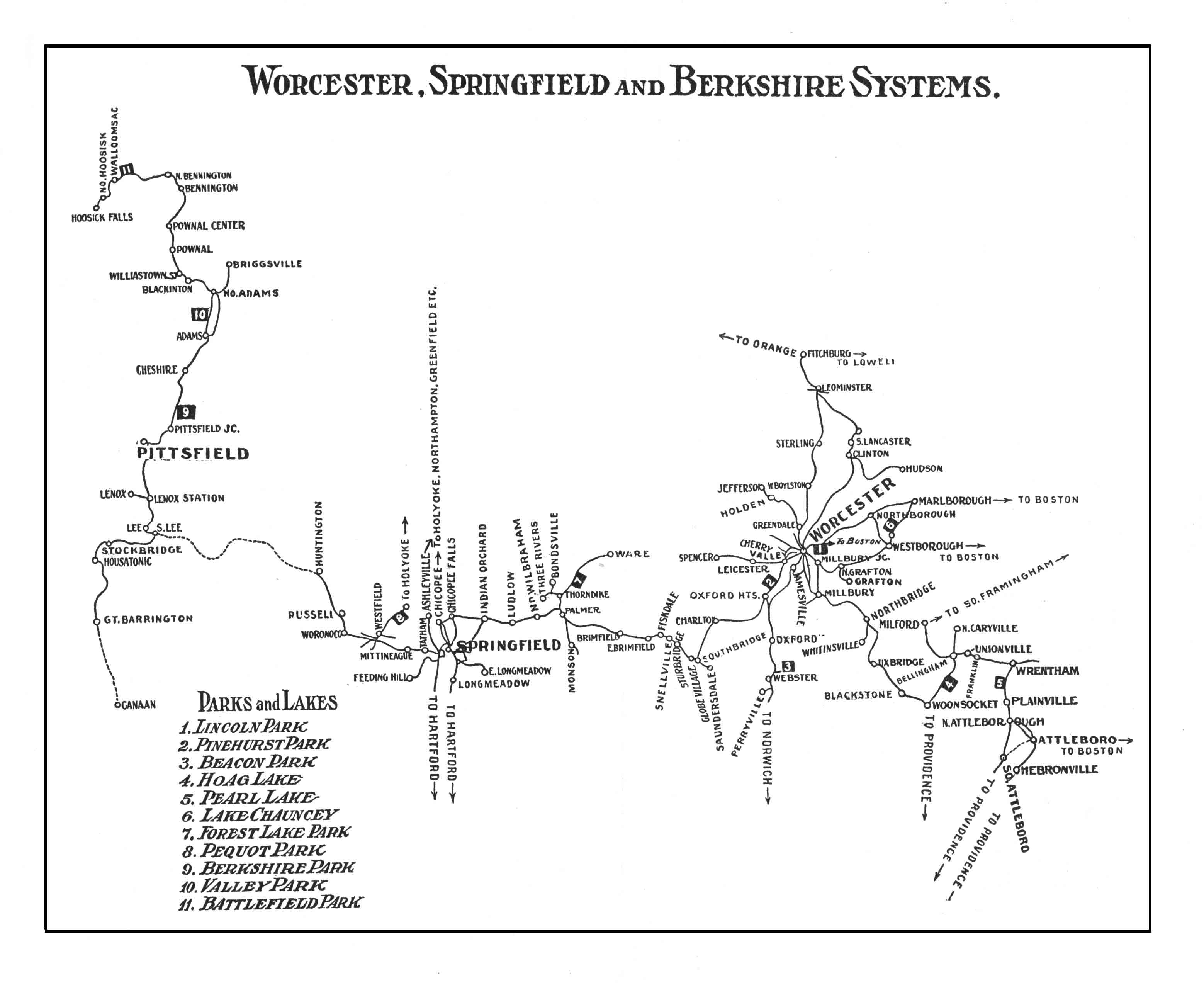
English: 1908 map of the New Haven Railroad's street railway properties in Massachusetts: the Berkshire Street Railway; Springfield Street Railway; Worcester Consolidated Street Railway; Milford, Attleborough and Woonsocket Street Railway; and Interstate Consolidated Street Railway |
| Date | |
| Source |
Scanned file from private collection Originally published in The Trolley Wayfinder, 1908 |
| Author | Unknown author |
| Other versions |

Licensing
[edit]
This image is in the public domain because it is a mere mechanical scan or photocopy of a public domain original, or – from the available evidence – is so similar to such a scan or photocopy that no copyright protection can be expected to arise. The original itself is in the public domain for the following reason:
This tag is designed for use where there may be a need to assert that any enhancements (eg brightness, contrast, colour-matching, sharpening) are in themselves insufficiently creative to generate a new copyright. It can be used where it is unknown whether any enhancements have been made, as well as when the enhancements are clear but insufficient. For known raw unenhanced scans you can use an appropriate {{PD-old}} tag instead. For usage, see Commons:When to use the PD-scan tag.  |
File history
Click on a date/time to view the file as it appeared at that time.
| Date/Time | Thumbnail | Dimensions | User | Comment | |
|---|---|---|---|---|---|
| current | 01:12, 25 February 2017 | | 3,117 × 2,547 (271 KB) | Pi.1415926535 (talk | contribs) | {{Information |Description ={{en|1=1908 map of the Worcester Consolidated, Springfield, and Berkshire street railway systems}} |Source =Scanned file from private collection |Author ={{unknown|author}} |Date =1908 |Permissio... |
You cannot overwrite this file.
File usage on Commons
The following 5 pages use this file:
- User:Chumwa/OgreBot/Potential transport maps/2017 February 19-28
- User:Chumwa/OgreBot/Public transport information/2017 February 19-28
- User:Chumwa/OgreBot/Transport Maps/2017 February 19-28
- User:Chumwa/OgreBot/Travel and communication maps/2017 February 19-28
- File:Worcester Consolidated Street Railway 1908 map.jpg