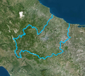
File:Confini del Molise-var.png
Confini_del_Molise-var.png (658 × 586 pixels, file size: 603 KB, MIME type: image/png)
Captions
Captions
Summary
[edit]| DescriptionConfini del Molise-var.png |
Italiano: Confini della regione Molise - Mappa di Institut géographique national |
||
| Date | original: 2020-07-13 / derivative work: 2024-02-16 | ||
| Source |
This file was derived from: Confini del Molise.png |
||
| Author |
|
||
| Permission (Reusing this file) |
|
||
| Other versions |
|
| This is a retouched picture, which means that it has been digitally altered from its original version. Modifications: per request. Modifications made by Arrow303.
|
This map was improved or created by the Wikigraphists of the Graphic Lab (it). You can propose images to clean up, improve, create or translate as well. |
File history
Click on a date/time to view the file as it appeared at that time.
| Date/Time | Thumbnail | Dimensions | User | Comment | |
|---|---|---|---|---|---|
| current | 12:30, 16 February 2024 |  | 658 × 586 (603 KB) | Arrow303 (talk | contribs) | {{Information |Description={{it|Confini della regione Molise - Mappa di Institut géographique national}} |Source={{Derived from|Confini del Molise.png}} |Date=original: 2020-07-13 / derivative work: 2024-02-16 |Author= *{{author|original|Institut géographique national}} *{{author|derivative|{{u|Arrow303}}}} |Permission={{Licence Ouverte}} |other_versions={{G|Confini del Molise.png}} }} {{Retouched picture|per request|editor=Arrow303}} {{Laboratorio grafico map... |
You cannot overwrite this file.
File usage on Commons
The following page uses this file:
File usage on other wikis
The following other wikis use this file:
- Usage on it.wikipedia.org
Metadata
This file contains additional information such as Exif metadata which may have been added by the digital camera, scanner, or software program used to create or digitize it. If the file has been modified from its original state, some details such as the timestamp may not fully reflect those of the original file. The timestamp is only as accurate as the clock in the camera, and it may be completely wrong.
| Horizontal resolution | 37.79 dpc |
|---|---|
| Vertical resolution | 37.79 dpc |


