File:Clifton (for Mayfield) station site geograph-3854011-by-Ben-Brooksbank.jpg
Jump to navigation
Jump to search

Size of this preview: 800 × 483 pixels. Other resolutions: 320 × 193 pixels | 640 × 386 pixels | 1,024 × 618 pixels | 1,280 × 772 pixels | 2,396 × 1,446 pixels.
Original file (2,396 × 1,446 pixels, file size: 3.7 MB, MIME type: image/jpeg)
Captions
Captions
Add a one-line explanation of what this file represents
Summary
[edit]_station_site_geograph-3854011-by-Ben-Brooksbank.jpg&action=edit§ion=1)
| Description |
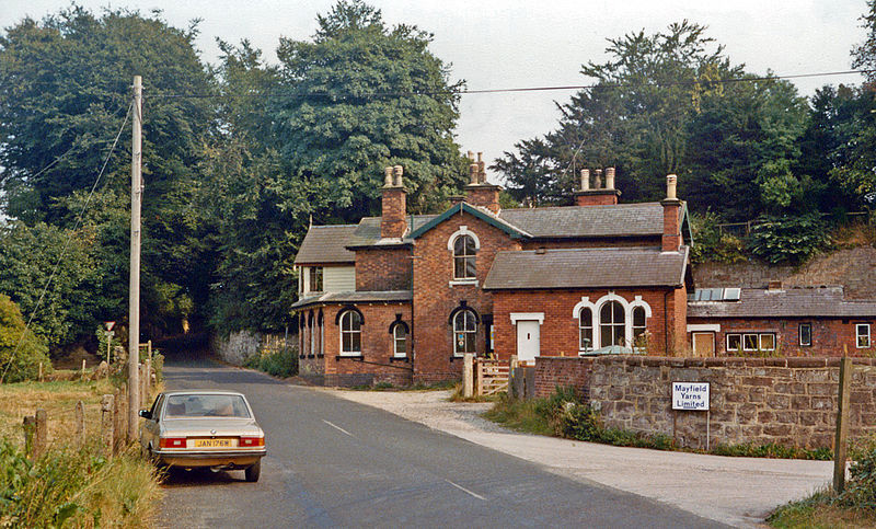
English: Site of Clifton (for Mayfield) station, 1983. View southward to the former level-crossing of the ex-North Stafford line, Uttoxeter (to right) - Ashbourne (to left). The station and the line had been closed to passengers 1/11/54, but goods traffic lasted until 7/10/63 |
| Date | |
| Source | From geograph.org.uk |
| Author | Ben Brooksbank |
| Permission (Reusing this file) |
Creative Commons Attribution Share-alike license 2.0 |
| Attribution (required by the license) | Ben Brooksbank / Site of Clifton (for Mayfield) station, 1983 / |
| Camera location | | View this and other nearby images on: OpenStreetMap |
|---|
_station_site_geograph-3854011-by-Ben-Brooksbank.jpg¶ms=053.000545_N_-001.758271_E_globe:Earth_type:camera_heading:135.00&language=en)
Licensing
[edit]_station_site_geograph-3854011-by-Ben-Brooksbank.jpg&action=edit§ion=2)

|
This image was taken from the Geograph project collection. See this photograph's page on the Geograph website for the photographer's contact details. The copyright on this image is owned by Ben Brooksbank and is licensed for reuse under the Creative Commons Attribution-ShareAlike 2.0 license.
|
This file is licensed under the Creative Commons Attribution-Share Alike 2.0 Generic license.
Attribution: Ben Brooksbank
- You are free:
- to share – to copy, distribute and transmit the work
- to remix – to adapt the work
- Under the following conditions:
- attribution – You must give appropriate credit, provide a link to the license, and indicate if changes were made. You may do so in any reasonable manner, but not in any way that suggests the licensor endorses you or your use.
- share alike – If you remix, transform, or build upon the material, you must distribute your contributions under the same or compatible license as the original.
File history
Click on a date/time to view the file as it appeared at that time.
| Date/Time | Thumbnail | Dimensions | User | Comment | |
|---|---|---|---|---|---|
| current | 07:43, 22 March 2014 | | 2,396 × 1,446 (3.7 MB) | Chevin (talk | contribs) | == {{int:filedesc}} == {{Information |Description={{en|1='''Site of Clifton (for Mayfield) station, 1983.'''<br/> View southward to the former level-crossing of the ex-North Stafford line, Uttoxeter (to right) - Ashbourne (to left). The station and the... |
You cannot overwrite this file.
File usage on Commons
The following page uses this file:
File usage on other wikis
The following other wikis use this file:
- Usage on en.wikipedia.org
_station_site_geograph-3854011-by-Ben-Brooksbank.jpg&oldid=939591710)