File:Cl-triconti-en.PNG
Jump to navigation
Jump to search
Size of this preview: 441 × 599 pixels. Other resolutions: 177 × 240 pixels | 353 × 480 pixels | 565 × 768 pixels | 754 × 1,024 pixels | 1,671 × 2,270 pixels.
Original file (1,671 × 2,270 pixels, file size: 1.72 MB, MIME type: image/png)
Captions
Captions
Add a one-line explanation of what this file represents
Summary
[edit]| Description |
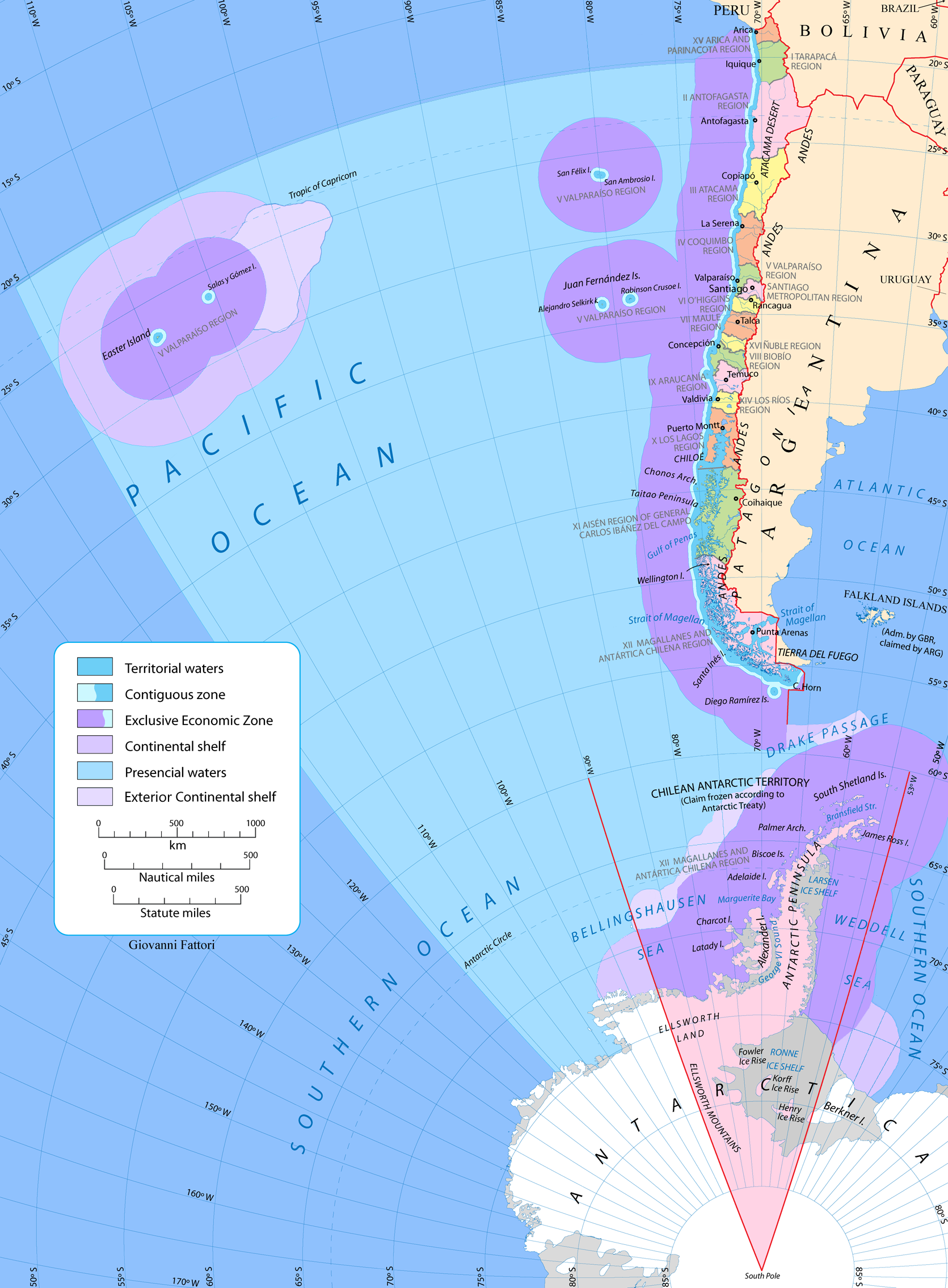
English: Map of Chile including antarctic claim and maritime zones ("tricontinental Chile") |
| Date | |
| Source | Own work |
| Author | Gi |
| Other versions | Cl-triconti.png |


Licensing
[edit]
I, the copyright holder of this work, hereby publish it under the following licenses:

|
Permission is granted to copy, distribute and/or modify this document under the terms of the GNU Free Documentation License, Version 1.2 or any later version published by the Free Software Foundation; with no Invariant Sections, no Front-Cover Texts, and no Back-Cover Texts. A copy of the license is included in the section entitled GNU Free Documentation License. |
| This file is licensed under the Creative Commons Attribution-Share Alike 3.0 Unported license. | ||
| ||
| This licensing tag was added to this file as part of the GFDL licensing update. |
| Copyleft: This work of art is free; you can redistribute it and/or modify it according to terms of the Free Art License. You will find a specimen of this license on the Copyleft Attitude site as well as on other sites. |
You may select the license of your choice.
File history
Click on a date/time to view the file as it appeared at that time.
| Date/Time | Thumbnail | Dimensions | User | Comment | |
|---|---|---|---|---|---|
| current | 19:06, 9 January 2024 | | 1,671 × 2,270 (1.72 MB) | Janitoalevic (talk | contribs) | Added Rapa Nui Continental Shelf |
| 18:38, 19 December 2023 |  | 1,671 × 2,270 (1.71 MB) | Janitoalevic (talk | contribs) | Fixes | |
| 19:27, 18 December 2023 |  | 1,671 × 2,270 (1.71 MB) | Janitoalevic (talk | contribs) | Added text | |
| 19:25, 18 December 2023 |  | 1,671 × 2,270 (1.71 MB) | Janitoalevic (talk | contribs) | Updated | |
| 15:51, 27 May 2020 |  | 1,671 × 2,270 (1.75 MB) | Janitoalevic (talk | contribs) | . | |
| 02:27, 3 August 2018 |  | 1,671 × 2,270 (1.51 MB) | Janitoalevic (talk | contribs) | . | |
| 01:24, 4 June 2018 |  | 1,671 × 2,270 (1.51 MB) | Janitoalevic (talk | contribs) | Updated map. | |
| 01:30, 5 March 2009 |  | 1,671 × 2,270 (1.72 MB) | Gi (talk | contribs) | ||
| 22:00, 6 February 2009 |  | 1,671 × 2,270 (1.72 MB) | Gi (talk | contribs) | {{Information |Description={{en|1=Map of Chile including antarctic claim and maritime zones ("tricontinental Chile")}} |Source=Own work by uploader |Author=Gi |Date=2009-02-06 |Permission= |other_versions= }} <!--{{ImageUpload|full}}--> [[Cat |
You cannot overwrite this file.
File usage on Commons
The following 4 pages use this file:
File usage on other wikis
The following other wikis use this file:
- Usage on ar.wikipedia.org
- Usage on ast.wikipedia.org
- Usage on azb.wikipedia.org
- Usage on bs.wikipedia.org
- Usage on en.wikipedia.org
- Usage on eu.wikipedia.org
- Usage on fa.wikipedia.org
- Usage on hy.wikipedia.org
- Usage on id.wikipedia.org
- Usage on ilo.wikipedia.org
- Usage on is.wikipedia.org
- Usage on la.wikipedia.org
- Usage on mk.wikipedia.org
- Usage on pa.wikipedia.org
- Usage on sh.wikipedia.org
- Usage on sl.wikipedia.org
- Usage on sr.wikipedia.org
- Usage on sv.wikipedia.org
- Usage on tr.wikipedia.org
- Usage on uk.wikipedia.org
- Usage on ur.wikipedia.org
- Usage on vi.wikipedia.org
- Usage on war.wikipedia.org
- Usage on www.wikidata.org
- Usage on zh.wikipedia.org