File:Chongqing Rail Transit system map 201812 ver 20190126.png
Jump to navigation
Jump to search
Size of this preview: 551 × 599 pixels. Other resolutions: 221 × 240 pixels | 441 × 480 pixels | 706 × 768 pixels | 941 × 1,024 pixels | 1,882 × 2,048 pixels | 5,937 × 6,459 pixels.
Original file (5,937 × 6,459 pixels, file size: 1.22 MB, MIME type: image/png)
Captions
Captions
Add a one-line explanation of what this file represents
Summary
[edit]
| Warning | The original file is very high-resolution. It might not load properly or could cause your browser to freeze when opened at full size. |
|---|
| Description |
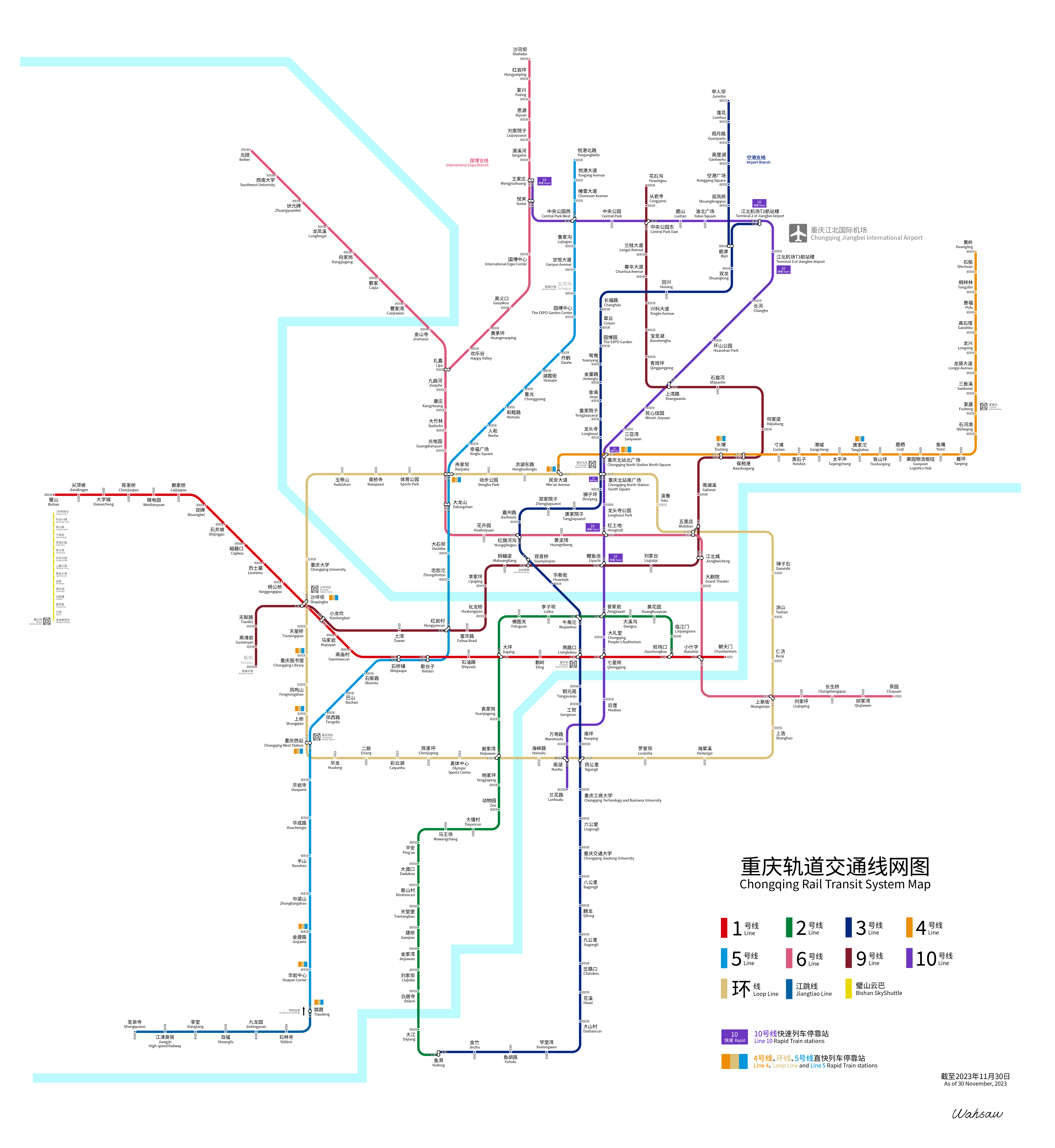
中文:重庆轨道交通线路图2018.12
使用en:Source Han Sans字体
English: Chongqing Rail Transit system map 201812
Using font en:Source Han Sans. |
| Date | |
| Source | Own work |
| Author | Wahsaw |
Licensing
[edit]
I, the copyright holder of this work, hereby publish it under the following license:
This file is licensed under the Creative Commons Attribution-Share Alike 4.0 International license.
- You are free:
- to share – to copy, distribute and transmit the work
- to remix – to adapt the work
- Under the following conditions:
- attribution – You must give appropriate credit, provide a link to the license, and indicate if changes were made. You may do so in any reasonable manner, but not in any way that suggests the licensor endorses you or your use.
- share alike – If you remix, transform, or build upon the material, you must distribute your contributions under the same or compatible license as the original.
File history
Click on a date/time to view the file as it appeared at that time.
| Date/Time | Thumbnail | Dimensions | User | Comment | |
|---|---|---|---|---|---|
| current | 09:10, 30 November 2023 | | 5,937 × 6,459 (1.22 MB) | Wahsaw (talk | contribs) | Line 5 and Line 10 extensions |
| 03:21, 8 October 2023 |  | 5,937 × 6,459 (1.23 MB) | Wahsaw (talk | contribs) | new stations open | |
| 09:09, 27 February 2023 |  | 5,937 × 6,459 (1.24 MB) | Wahsaw (talk | contribs) | Line 5 extension | |
| 07:44, 24 January 2023 |  | 6,297 × 6,851 (1.3 MB) | Wahsaw (talk | contribs) | Line 9, 10 extensions | |
| 13:08, 30 September 2022 |  | 5,201 × 5,659 (1,002 KB) | Wahsaw (talk | contribs) | Shapingba in-station transfer | |
| 07:36, 7 August 2022 |  | 5,346 × 5,817 (1.01 MB) | Wahsaw (talk | contribs) | Jiangtiao Line | |
| 15:59, 19 June 2022 |  | 8,993 × 9,785 (2.57 MB) | Wahsaw (talk | contribs) | Line 4 extension | |
| 16:04, 25 January 2022 |  | 8,993 × 9,785 (2.46 MB) | Wahsaw (talk | contribs) | Line 9 phase 1 and minor updates | |
| 02:46, 20 January 2021 |  | 8,993 × 9,785 (2.25 MB) | Wahsaw (talk | contribs) | Line 5 southern section and Loop Line | |
| 08:53, 8 January 2021 |  | 8,801 × 9,497 (2.01 MB) | Wahsaw (talk | contribs) | new stations |
You cannot overwrite this file.
File usage on Commons
The following 28 pages use this file:
- 重庆
- User:Chumwa/OgreBot/Potential transport maps/2019 December 21-31
- User:Chumwa/OgreBot/Potential transport maps/2019 January 21-31
- User:Chumwa/OgreBot/Public transport information/2019 December 21-31
- User:Chumwa/OgreBot/Public transport information/2019 January 21-31
- User:Chumwa/OgreBot/Public transport information/2021 January 1-10
- User:Chumwa/OgreBot/Public transport information/2021 January 11-20
- User:Chumwa/OgreBot/Public transport information/2022 August 1-10
- User:Chumwa/OgreBot/Public transport information/2022 January 21-31
- User:Chumwa/OgreBot/Public transport information/2022 June 11-20
- User:Chumwa/OgreBot/Public transport information/2022 September 21-30
- User:Chumwa/OgreBot/Public transport information/2023 February 19-28
- User:Chumwa/OgreBot/Public transport information/2023 January 21-31
- User:Chumwa/OgreBot/Public transport information/2023 November 21-30
- User:Chumwa/OgreBot/Public transport information/2023 October 1-10
- User:Chumwa/OgreBot/Transport Maps/2019 December 21-31
- User:Chumwa/OgreBot/Transport Maps/2019 January 21-31
- User:Chumwa/OgreBot/Transport Maps/2021 January 1-10
- User:Chumwa/OgreBot/Transport Maps/2021 January 11-20
- User:Chumwa/OgreBot/Transport Maps/2022 August 1-10
- User:Chumwa/OgreBot/Transport Maps/2022 January 21-31
- User:Chumwa/OgreBot/Transport Maps/2022 June 11-20
- User:Chumwa/OgreBot/Transport Maps/2022 September 21-30
- User:Chumwa/OgreBot/Transport Maps/2023 February 19-28
- User:Chumwa/OgreBot/Transport Maps/2023 January 21-31
- User:Chumwa/OgreBot/Transport Maps/2023 November 21-30
- User:Chumwa/OgreBot/Transport Maps/2023 October 1-10
- User:Chumwa/OgreBot/Travel and communication maps/2019 January 21-31
File usage on other wikis
The following other wikis use this file:
- Usage on ca.wikipedia.org
- Usage on de.wikipedia.org
- Usage on en.wikipedia.org
- Usage on eo.wikipedia.org
- Usage on es.wikipedia.org
- Usage on eu.wikipedia.org
- Usage on fi.wikipedia.org
- Usage on fr.wikipedia.org
- Usage on id.wikipedia.org
- Usage on is.wikipedia.org
- Usage on nl.wikipedia.org
- Usage on pl.wikipedia.org
- Usage on ru.wikipedia.org
- Usage on sv.wikipedia.org
- Usage on th.wikipedia.org
- Usage on tr.wikipedia.org
- Usage on uk.wikipedia.org
- Usage on uz.wikipedia.org
- Usage on zh.wikipedia.org
- Usage on zh.wikivoyage.org