File:Central Interior Highlands (MODIS 2019-12-16).jpg
Jump to navigation
Jump to search

Size of this preview: 751 × 599 pixels. Other resolutions: 301 × 240 pixels | 602 × 480 pixels | 963 × 768 pixels | 1,280 × 1,021 pixels | 2,560 × 2,043 pixels | 3,083 × 2,460 pixels.
Original file (3,083 × 2,460 pixels, file size: 1.04 MB, MIME type: image/jpeg)
Captions
Captions
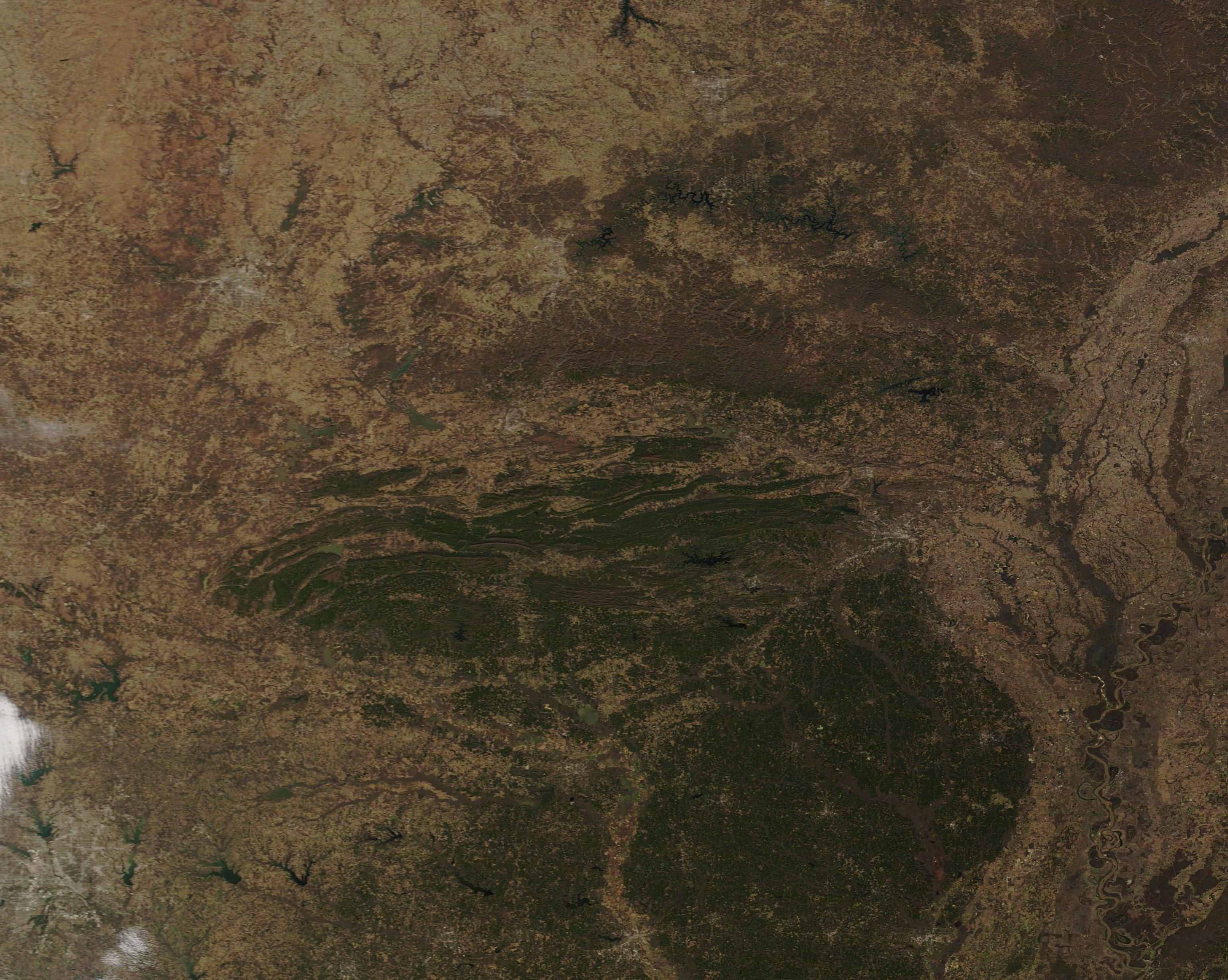
On December 11, 2019, the Moderate Resolution Imaging Spectroradiometer (MODIS) on board NASA’s Terra satellite acquired a true-color image of the southern section of the Interior Highlands wearing the colors of late autumn.
Summary
[edit].jpg&action=edit§ion=1)
| Description |
English: The only major mountainous region between the eastern Appalachians and western Rocky Mountains, the Interior Highlands of the United States stretch across part of Missouri, Arkansas, and eastern Oklahoma. This unique ecosystem consists of three major topographical divisions. From south to north these are the Ouachita Mountains, Arkansas Valley and Ozark Uplift.
On December 11, 2019, the Moderate Resolution Imaging Spectroradiometer (MODIS) on board NASA’s Terra satellite acquired a true-color image of the southern section of the Interior Highlands wearing the colors of late autumn. Fallow fields, grassland and open land appear tan or brown, while forests appear green. The Ouachita Mountains are aligned on an east-west axis, unlike the Rockies or Appalachians, which rise on a generally north-to-east axis. These mountains formed about 300 million years ago when the South American Plate drifted northward, colliding with the North American Plate, and creating huge folds in the northern landmass. Immediately north of the Ouachita Mountains, the Arkansas River Valley dips downward, sandwiched between the fold mountains and the steep escarpment that marks the start of the Ozark Uplift. |
||
| Date | Taken on 11 December 2019 | ||
| Source |
Central Interior Highlands (direct link)
|
||
| Author | MODIS Land Rapid Response Team, NASA GSFC |
| This media is a product of the Terra mission Credit and attribution belongs to the mission team, if not already specified in the "author" row |
Licensing
[edit].jpg&action=edit§ion=2)
| This file is in the public domain in the United States because it was solely created by NASA. NASA copyright policy states that "NASA material is not protected by copyright unless noted". (See Template:PD-USGov, NASA copyright policy page or JPL Image Use Policy.) | ||
 |
Warnings:
|
File history
Click on a date/time to view the file as it appeared at that time.
| Date/Time | Thumbnail | Dimensions | User | Comment | |
|---|---|---|---|---|---|
| current | 02:40, 17 February 2024 | | 3,083 × 2,460 (1.04 MB) | OptimusPrimeBot (talk | contribs) | #Spacemedia - Upload of http://modis.gsfc.nasa.gov/gallery/images/image12162019_250m.jpg via Commons:Spacemedia |
You cannot overwrite this file.
File usage on Commons
There are no pages that use this file.
.jpg&oldid=909380736)