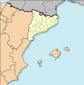
File:CatalunyaLoc-NUTS-ES51.svg

Original file (SVG file, nominally 1,101 × 1,108 pixels, file size: 566 KB)
Captions
Captions
| DescriptionCatalunyaLoc-NUTS-ES51.svg |
Catalonia Location Map Spain Location Map Català: Comunitats Autònomes d'Espanya segons NUTS-ES1.
English: Spanish Autonomous Communities according to NUTS-ES1. |
| Date | (UTC) |
| Source | |
| Author |
|
| This is a retouched picture, which means that it has been digitally altered from its original version. The original can be viewed here: Mapa mut dels Països Catalans.svg: File:Mapa mut dels Països Catalans.svg.
|
- You are free:
- to share – to copy, distribute and transmit the work
- to remix – to adapt the work
- Under the following conditions:
- attribution – You must give appropriate credit, provide a link to the license, and indicate if changes were made. You may do so in any reasonable manner, but not in any way that suggests the licensor endorses you or your use.
- share alike – If you remix, transform, or build upon the material, you must distribute your contributions under the same or compatible license as the original.
Original upload log
[edit]This image is a derivative work of the following images:
- File:CatalunyaLoc.svg licensed with PD-self
- 2008-04-27T09:34:23Z HansenBCN 3300x2500 (466651 Bytes) Sombreado de agua descentrado y borde superior eliminado
- 2008-04-26T14:38:41Z HansenBCN 3300x2500 (463617 Bytes) Bordes
- 2008-04-26T14:32:01Z HansenBCN 3300x2500 (463380 Bytes) == Summary == {{Information |Description=Catalonia Location Map |Source=self-made |Date=26/april/2008 |Author= [[User:HansenBCN|HansenBCN]] |Permission= |other_versions=[Image:CatalunyaLoc.png|50px] }} == [[Commons:Copyright
- File:EspañaLoc.svg licensed with PD-self
- 2008-04-27T09:28:59Z HansenBCN 3300x1885 (1994472 Bytes) Sombreado de agua - desplazado - y fronteras provinciales más tenues
- 2008-04-26T19:23:21Z HansenBCN 3300x1885 (1979162 Bytes) +fronteras provinciales
- 2008-04-26T14:39:03Z HansenBCN 3300x1885 (990679 Bytes) Bordes
- 2008-04-26T14:34:27Z HansenBCN 3300x1885 (990679 Bytes) == Summary == {{Information |Description=Spain Location Map |Source=self-made |Date=26/april/2008 |Author= [[User:HansenBCN|HansenBCN]] |Permission= |other_versions=[[Image:SpainLOC.png|50px]] }} == [[Commons:Copyright tags|
- File:Mapa_mut_dels_Països_Catalans.svg licensed with Cc-by-sa-3.0
- 2009-12-27T14:34:57Z Martorell 0x0 (951152 Bytes) Correcting error code on SVG.
- 2009-12-27T14:09:57Z Martorell 0x0 (937946 Bytes) Errors on SVG code.
- 2009-12-27T14:06:39Z Martorell 0x0 (1437692 Bytes) {{Information |Description={{ca|1=Països de parla catalana}} {{en|1=Catalan-speaking countries}} |Source=*[[:File:Paisos_catalans.svg|]] *[[:File:Mapa_Euroregió_Pirineus_Mediterrània.svg|]] |Date=2009-12-27 14:00 (UTC) |Au
Uploaded with derivativeFX
File history
Click on a date/time to view the file as it appeared at that time.
| Date/Time | Thumbnail | Dimensions | User | Comment | |
|---|---|---|---|---|---|
| current | 18:59, 4 November 2023 |  | 1,101 × 1,108 (566 KB) | Lojwe (talk | contribs) | Removing frame |
| 15:37, 28 December 2009 |  | 1,101 × 1,108 (1.14 MB) | Martorell (talk | contribs) | Same reason. | |
| 22:51, 27 December 2009 |  | 1,101 × 1,108 (892 KB) | Martorell (talk | contribs) | Correcting SVG code errors. | |
| 22:47, 27 December 2009 | No thumbnail | (1.46 MB) | Martorell (talk | contribs) | Reverted to version as of 22:41, 27 December 2009 | |
| 22:46, 27 December 2009 |  | 1,101 × 1,108 (1.5 MB) | Martorell (talk | contribs) | Correcting error code on SVG. | |
| 22:41, 27 December 2009 | No thumbnail | (1.46 MB) | Martorell (talk | contribs) | {{Information |Description=Catalonia Location Map Spain Location Map {{ca|1=Comunitats Autònomes d'Espanya segons NUTS-ES1.}} {{en|1=Spanish Autonomous Communities according to NUTS-ES1.}} |Source=*File:CatalunyaLoc.svg *[ |
You cannot overwrite this file.
File usage on Commons
The following 4 pages use this file:
File usage on other wikis
The following other wikis use this file:
- Usage on ca.wikipedia.org
Metadata
This file contains additional information such as Exif metadata which may have been added by the digital camera, scanner, or software program used to create or digitize it. If the file has been modified from its original state, some details such as the timestamp may not fully reflect those of the original file. The timestamp is only as accurate as the clock in the camera, and it may be completely wrong.
| Width | 310.621mm |
|---|---|
| Height | 312.737mm |