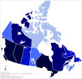
File:Canadian provinces and territories by HDI (2015).svg
From Wikimedia Commons, the free media repository
Jump to navigation
Jump to search

Size of this PNG preview of this SVG file: 512 × 493 pixels. Other resolutions: 249 × 240 pixels | 499 × 480 pixels | 798 × 768 pixels | 1,063 × 1,024 pixels | 2,127 × 2,048 pixels.
Original file (SVG file, nominally 512 × 493 pixels, file size: 103 KB)
File information
Structured data
Captions
Captions
Add a one-line explanation of what this file represents
Summary
[edit]| DescriptionCanadian provinces and territories by HDI (2015).svg |
English: Map of the HDI of the provinces and territories of Canada in 2015.
Français : Carte de l'IDH (2015) des provinces et des territoires du Canada.
Português: Mapa do IDH (2015) das províncias e territórios do Canadá.
Legend: |
| Date | |
| Source | Own work based on: Canada blank map.svg |
| Author | Allice Hunter |
| SVG development InfoField |
Licensing
[edit]| Public domainPublic domainfalsefalse |
| This map is ineligible for copyright and therefore in the public domain, because it consists entirely of information that is common property and contains no original authorship. For more information, see Commons:Threshold of originality § Maps.
English | Español | Galego | Română | slovenščina | العربية | 简体中文 | 繁體中文 | +/− |
File history
Click on a date/time to view the file as it appeared at that time.
| Date/Time | Thumbnail | Dimensions | User | Comment | |
|---|---|---|---|---|---|
| current | 02:01, 6 March 2019 |  | 512 × 493 (103 KB) | Allice Hunter (talk | contribs) | Adjustment |
| 01:59, 6 March 2019 |  | 512 × 493 (51 KB) | Allice Hunter (talk | contribs) | No transparent background | |
| 20:21, 20 August 2018 |  | 1,294 × 1,253 (73 KB) | Allice Hunter (talk | contribs) | No raster graphics | |
| 15:52, 22 September 2017 |  | 512 × 496 (216 KB) | Allice Hunter (talk | contribs) | Cross-wiki upload from pt.wikipedia.org |
You cannot overwrite this file.
File usage on Commons
The following page uses this file:
- File:Can Provinces by HDI (2015).svg (file redirect)
File usage on other wikis
The following other wikis use this file:
- Usage on fr.wikipedia.org
- Usage on tr.wikipedia.org
- Usage on zh.wikipedia.org
Metadata
This file contains additional information such as Exif metadata which may have been added by the digital camera, scanner, or software program used to create or digitize it. If the file has been modified from its original state, some details such as the timestamp may not fully reflect those of the original file. The timestamp is only as accurate as the clock in the camera, and it may be completely wrong.
| Width | 100% |
|---|---|
| Height | 100% |