File:Buryatia01.png
Jump to navigation
Jump to search

Size of this preview: 800 × 567 pixels. Other resolutions: 320 × 227 pixels | 640 × 454 pixels | 1,066 × 756 pixels.
Original file (1,066 × 756 pixels, file size: 60 KB, MIME type: image/png)
Captions
Captions
Add a one-line explanation of what this file represents
Summary
[edit]
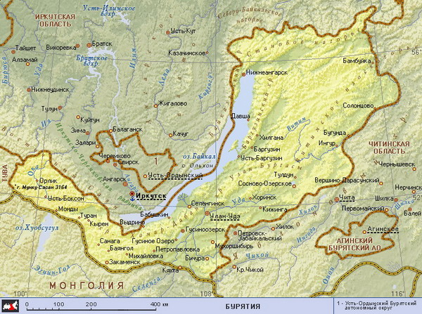
| Description | Map of the Republic of Buryatia, Aga Buryatia (Agin-Buryat Autonomous Okrug) and Ust-Orda Buryatia (Ust-Orda Buryat Autonomous Okrug) in Russia, until 2008. |
| Date | |
| Source | Own work |
| Author | PANONIAN |
Licensing
[edit]
I, the copyright holder of this work, hereby publish it under the following license:
| This file is made available under the Creative Commons CC0 1.0 Universal Public Domain Dedication. | |
| The person who associated a work with this deed has dedicated the work to the public domain by waiving all of their rights to the work worldwide under copyright law, including all related and neighboring rights, to the extent allowed by law. You can copy, modify, distribute and perform the work, even for commercial purposes, all without asking permission.
|
References
[edit]
Maps from external links:
- http://planetolog.ru/maps/russia-oblast/Buryatia.jpg
- http://freemedline.ru/userfiles/map_burat.gif[dead link]
- http://loi.sscc.ru/bdm/nso/attr/sfo/img/buryatia.gif archive copy at the Wayback Machine
- http://vsemirniysledopyt.ru/i/58/164158/i_001.png
- http://rdaward.org/map/0o.jpg
- http://files.vector-images.com/clipart/buryatia_map.gif archive copy at the Wayback Machine
- http://www.stalvik.com/images/Kartor/karta_burjatien.jpg
- http://www.ulan-medium.com/wp-content/uploads/2012/03/Buryatia.jpg
- http://www.vodnyimir.ru/images/map/Irkutskaya_obl.jpg
- http://www.sbaikal.ru/pic/tourism/mapbur.gif
- http://www.hge.pu.ru/mapgis/subekt/buryat/buryat.gif
- http://www.ruschamber.net/Logos/Articles/1400/buryatia.gif archive copy at the Wayback Machine
- http://trasa.ru/img/regions/buriatiya.gif
- http://www.aquaexpert.ru/id_pict/region_11.gif
- http://www.svyato.info/uploads/map/burjatija-respublika.gif archive copy at the Wayback Machine
- http://rosavtodor.ru/doc/dorognye_fondy/buryatiya_b.jpg archive copy at the Wayback Machine
- http://www.regions.newsall.ru/buriatia/Buriaia.gif
- http://dic.academic.ru/pictures/enc_geo/Buryatia.jpg
- http://www.mapzones.com/citymap/russia/republic_of_buryatia/republic_of_buryatia.jpg
- http://russiaprofile.org/p-38660-cur_image.ajax?media_id=3811&_=1295871887 archive copy at the Wayback Machine
- http://ars.sciencedirect.com/content/image/1-s2.0-S0269749106003782-gr1.jpg[dead link]
- http://museum.gulagmemories.eu/sites/default/files/Buriatia_F.jpg
Largest cities and towns in Buryatia:
File history
Click on a date/time to view the file as it appeared at that time.
| Date/Time | Thumbnail | Dimensions | User | Comment | |
|---|---|---|---|---|---|
| current | 09:14, 10 August 2012 | | 1,066 × 756 (60 KB) | WikiEditor2004 (talk | contribs) | {{Information |Description=Map of the Republic of Buryatia, Aga Buryatia (Agin-Buryat Autonomous Okrug) and Ust-Orda Buryatia (Ust-Orda Buryat Autonomous Okrug) in Russia, until 2008. |Source={{own}} |Date= |Author= PANONIAN |Permissi... |
You cannot overwrite this file.
File usage on Commons
The following 2 pages use this file:
File usage on other wikis
The following other wikis use this file:
- Usage on azb.wikipedia.org
- Usage on ca.wikipedia.org
- Usage on de.wikipedia.org
- Usage on en.wikipedia.org
- Usage on fi.wikipedia.org
- Usage on it.wikipedia.org
- Usage on lt.wikipedia.org
- Usage on mn.wikipedia.org
- Usage on sr.wikipedia.org
- Usage on uk.wikipedia.org
- Usage on vi.wikipedia.org
- Usage on zh.wikipedia.org