File:Budapest railway lines map.svg
Jump to navigation
Jump to search

Size of this PNG preview of this SVG file: 596 × 600 pixels. Other resolutions: 238 × 240 pixels | 477 × 480 pixels | 763 × 768 pixels | 1,018 × 1,024 pixels | 2,035 × 2,048 pixels | 1,899 × 1,911 pixels.
Original file (SVG file, nominally 1,899 × 1,911 pixels, file size: 1.92 MB)
Captions
Captions
Add a one-line explanation of what this file represents
Summary
[edit]
| Description |
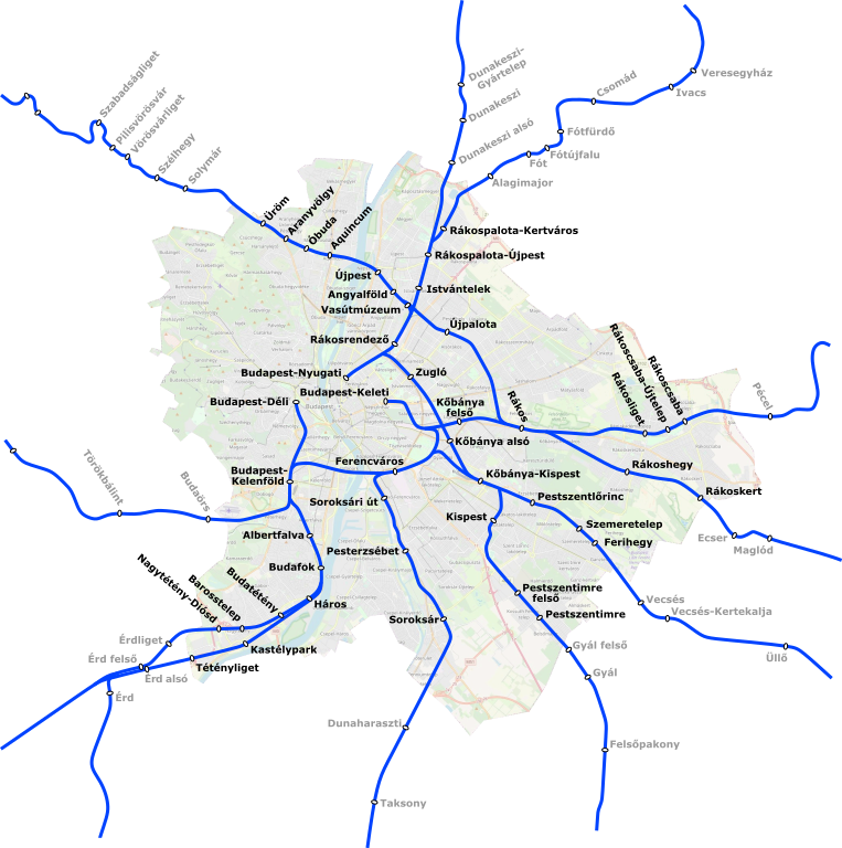
Magyar: Budapest vasútvonalai és vasútállomásai |
| Date | |
| Source | Own work |
| Author | Kemenymate |
Licensing
[edit]
| Description |
This map was created from OpenStreetMap project data, collected by the community. This map may be incomplete, and may contain errors. Don't rely solely on it for navigation. |
|||
| Date | (see file history) | |||
| Source | openstreetmap.org | |||
| Creator |
OpenStreetMap contributors |
|||
| Permission (Reusing this file) |
OpenStreetMap data is available under the Open Database License (details). Map tiles are licensed under the Creative Commons Attribution-ShareAlike 2.0 license (CC-BY-SA 2.0).
This file is licensed under the Creative Commons Attribution-Share Alike 2.0 Generic license.
|
|||
| Georeferencing |
File history
Click on a date/time to view the file as it appeared at that time.
| Date/Time | Thumbnail | Dimensions | User | Comment | |
|---|---|---|---|---|---|
| current | 16:08, 27 August 2023 | | 1,899 × 1,911 (1.92 MB) | Kemenymate (talk | contribs) | Rákoskert |
| 11:51, 25 October 2020 |  | 1,652 × 1,639 (1.91 MB) | Kemenymate (talk | contribs) | Újpalota | |
| 21:07, 8 November 2019 |  | 1,546 × 1,466 (1.35 MB) | Kemenymate (talk | contribs) | minor change | |
| 21:04, 8 November 2019 |  | 1,546 × 1,466 (1.35 MB) | Kemenymate (talk | contribs) | User created page with UploadWizard |
You cannot overwrite this file.
File usage on Commons
The following 7 pages use this file:
- User:Chumwa/OgreBot/Potential transport maps/2019 November 1-10
- User:Chumwa/OgreBot/Public transport information/2019 November 1-10
- User:Chumwa/OgreBot/Public transport information/2020 October 21-31
- User:Chumwa/OgreBot/Public transport information/2023 August 21-31
- User:Chumwa/OgreBot/Transport Maps/2019 November 1-10
- User:Chumwa/OgreBot/Transport Maps/2020 October 21-31
- User:Chumwa/OgreBot/Transport Maps/2023 August 21-31
File usage on other wikis
The following other wikis use this file:
- Usage on en.wikipedia.org
- Usage on hu.wikipedia.org
- Usage on www.wikidata.org