File:Bridges across the Blue Nile Gorge2.jpg
Jump to navigation
Jump to search

Size of this preview: 693 × 600 pixels. Other resolutions: 277 × 240 pixels | 555 × 480 pixels | 887 × 768 pixels | 1,183 × 1,024 pixels | 1,296 × 1,122 pixels.
Original file (1,296 × 1,122 pixels, file size: 1.39 MB, MIME type: image/jpeg)
Captions
Captions
Add a one-line explanation of what this file represents
Summary
[edit]| Description |
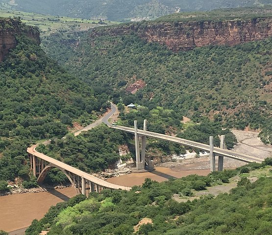
English: The older (left) Italian-built bridge and recently completed Japanese-built bridge across the Blue Nile Gorge in Ethiopia near the town of Goha Tsion. The Italian bridge is now used by pedestrians, while the Japanese bridge carries Ethiopian National Highway 3 between Addis Ababa and Bahir Dar. The Blue Nile river sets the border between Amhara and Oromia regions. |
| Date | |
| Source | Own work |
| Author | rosemania |
| Other versions |
|

| Camera location | | View this and other nearby images on: OpenStreetMap |
|---|
Licensing
[edit]
I, the copyright holder of this work, hereby publish it under the following license:
This file is licensed under the Creative Commons Attribution-Share Alike 4.0 International license.
- You are free:
- to share – to copy, distribute and transmit the work
- to remix – to adapt the work
- Under the following conditions:
- attribution – You must give appropriate credit, provide a link to the license, and indicate if changes were made. You may do so in any reasonable manner, but not in any way that suggests the licensor endorses you or your use.
- share alike – If you remix, transform, or build upon the material, you must distribute your contributions under the same or compatible license as the original.
File history
Click on a date/time to view the file as it appeared at that time.
| Date/Time | Thumbnail | Dimensions | User | Comment | |
|---|---|---|---|---|---|
| current | 16:19, 1 January 2020 | | 1,296 × 1,122 (1.39 MB) | Glabb (talk | contribs) | =={{int:filedesc}}== {{Information |description={{en|1=The older (left) Italian-built bridge and recently completed Japanese-built bridge across the Blue Nile Gorge in Ethiopia near the town of Goha Tsion. The Italian bridge is now used by pedestrians, while the Japanese bridge carries Ethiopian National Highway 3 between Addis Ababa and Bahir Dar. The Blue Nile river sets the border between Amhara and Oromia regions.}} |date=2017-09-23 12:52:41 |source={{own}} |author=[[User:Rosemania|rosema... |
You cannot overwrite this file.
File usage on Commons
The following 2 pages use this file:
File usage on other wikis
The following other wikis use this file:
- Usage on en.wikipedia.org