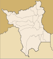
File:Brazil Roraima location map.svg

Original file (SVG file, nominally 624 × 687 pixels, file size: 228 KB)
Captions
Captions
| DescriptionBrazil Roraima location map.svg |
Location map of Roraima state. Geographic limits of the map:
|
| Date | (UTC) |
| Source | |
| Author |
|
- You are free:
- to share – to copy, distribute and transmit the work
- to remix – to adapt the work
- Under the following conditions:
- attribution – You must give appropriate credit, provide a link to the license, and indicate if changes were made. You may do so in any reasonable manner, but not in any way that suggests the licensor endorses you or your use.
| This file is licensed under the Creative Commons Attribution-Share Alike 3.0 Unported license. | ||
| ||
| This licensing tag was added to this file as part of the GFDL licensing update.http://creativecommons.org/licenses/by-sa/3.0/CC BY-SA 3.0Creative Commons Attribution-Share Alike 3.0truetrue |

|
Permission is granted to copy, distribute and/or modify this document under the terms of the GNU Free Documentation License, Version 1.2 or any later version published by the Free Software Foundation; with no Invariant Sections, no Front-Cover Texts, and no Back-Cover Texts. A copy of the license is included in the section entitled GNU Free Documentation License.http://www.gnu.org/copyleft/fdl.htmlGFDLGNU Free Documentation Licensetruetrue |
Uploaded with derivativeFX
File history
Click on a date/time to view the file as it appeared at that time.
| Date/Time | Thumbnail | Dimensions | User | Comment | |
|---|---|---|---|---|---|
| current | 20:30, 20 January 2019 |  | 624 × 687 (228 KB) | Milenioscuro (talk | contribs) | Does not match with the color conventions |
| 22:54, 19 January 2019 |  | 501 × 553 (234 KB) | Allice Hunter (talk | contribs) | Melhora nos gráficos | |
| 01:13, 14 August 2011 |  | 624 × 687 (228 KB) | Milenioscuro (talk | contribs) | {{Information |Description=Location map of Roraima state |Source=*File:Roraima_MesoMicroMunicip.svg |Date=2011-08-14 01:12 (UTC) |Author=*File:Roraima_MesoMicroMunicip.svg: Raphael Lorenzeto de Abreu *derivative work: ~~~ |Permission= |other_v |
You cannot overwrite this file.
File usage on Commons
The following 14 pages use this file:
- File:Mapa do IDH de Roraima (2010).svg
- File:Região Imediata de Boa Vista, Roraima.svg
- File:Região Imediata de Caracaraí, Roraima.svg
- File:Região Imediata de Pacaraima, Roraima.svg
- File:Região Imediata de Rorainópolis, Roraima.svg
- File:Região Intermediária de Boa Vista, Roraima.svg
- File:Região Intermediária de Rorainópolis-Caracaraí, Roraima.svg
- File:Regiões Geográficas do Estado de Roraima.svg
- Category:Airports in Roraima
- Category:Bridges in Roraima
- Category:Flora of Roraima (state)
- Category:Maps of Roraima
- Category:People of Roraima
- Category:Roraima
File usage on other wikis
The following other wikis use this file:
- Usage on de.wikipedia.org
- Usage on en.wikipedia.org
- Takutu River
- Cantá
- Iracema, Roraima
- São João da Baliza
- Boa Vista International Airport
- 2014 Roraima gubernatorial election
- Waimiri Atroari Indigenous Territory
- Module:Location map/data/Roraima
- Module:Location map/data/Roraima/doc
- Anauá National Forest
- Santa Maria do Boiaçu
- Boa Vista Air Force Base
- 2023 Campeonato Roraimense
- Usage on es.wikipedia.org
- Usage on fr.wikipedia.org
- Usage on he.wikipedia.org
- Usage on ia.wikipedia.org
- Usage on it.wikipedia.org
- Usage on kbd.wikipedia.org
- Usage on os.wikipedia.org
- Usage on pl.wikipedia.org
View more global usage of this file.
Metadata
This file contains additional information such as Exif metadata which may have been added by the digital camera, scanner, or software program used to create or digitize it. If the file has been modified from its original state, some details such as the timestamp may not fully reflect those of the original file. The timestamp is only as accurate as the clock in the camera, and it may be completely wrong.
| Width | 176mm |
|---|---|
| Height | 194mm |