File:Brač, Croatia OpenStreetMap.png
Jump to navigation
Jump to search
Size of this preview: 800 × 357 pixels. Other resolutions: 320 × 143 pixels | 640 × 285 pixels | 1,024 × 457 pixels | 2,067 × 922 pixels.
Original file (2,067 × 922 pixels, file size: 1.03 MB, MIME type: image/png)
Captions
Captions
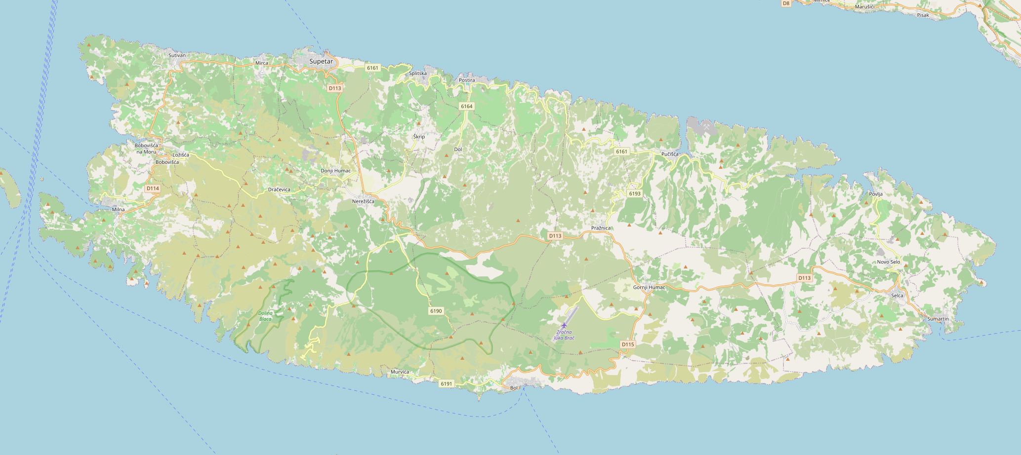
Brač, Croatia
Summary
[edit]
| Description |
English: Brač, Croatia |
| Date | |
| Source | openstreetmap.org |
| Author | OpenStreetMap contributors |
Licensing
[edit]
| Description |
This map of Brač was created from OpenStreetMap project data, collected by the community. This map may be incomplete, and may contain errors. Don't rely solely on it for navigation. |
|||
| Date | (see file history) | |||
| Source | openstreetmap.org | |||
| Creator |
OpenStreetMap contributors |
|||
| Permission (Reusing this file) |
OpenStreetMap data is available under the Open Database License (details). Map tiles are licensed under the Creative Commons Attribution-ShareAlike 2.0 license (CC-BY-SA 2.0).
This file is licensed under the Creative Commons Attribution-Share Alike 2.0 Generic license.
|
|||
| Georeferencing | If inappropriate please set warp_status = skip to hide. |
File history
Click on a date/time to view the file as it appeared at that time.
| Date/Time | Thumbnail | Dimensions | User | Comment | |
|---|---|---|---|---|---|
| current | 21:42, 11 December 2023 | | 2,067 × 922 (1.03 MB) | Argo Navis (talk | contribs) | Uploaded own work with UploadWizard |
You cannot overwrite this file.
File usage on Commons
There are no pages that use this file.
File usage on other wikis
The following other wikis use this file:
- Usage on hr.wikipedia.org
- Brač
- Vičja luka
- Crkva sv. Vida na Vidovoj gori
- Antički brodolom kod Sutivana na Braču
- Rat (Ložišća)
- Arheološko nalazište i crkva sv. Ilije u Donjem Humcu
- Crkva Stomorica na Braču
- Crkva sv. Ciprijana u Pražnicama
- Crkva sv. Fabijana i Sebastijana u Donjem Humcu
- Crkva sv. Filipa i Jakova u Nerežišćima
- Crkva sv. Ivana i Teodora u Bolu
- Crkva sv. Ivana s ranokršćanskom crkvom kod Sutivana
- Crkva sv. Jeronima u Pučišćima
- Crkva sv. Josipa u Nerežišćima
- Crkva sv. Jurja u Straževniku
- Crkva sv. Jurja u Nerežišćima
- Crkva sv. Klementa u Straževniku
- Crkva sv. Luke kod Supetra
- Crkva sv. Nedjelje kod Selca
- Crkva sv. Nikole kod Sumartina
- Crkva sv. Roka kod Supetra
- Donji pisk kod Ložišća
- Kameni most kod Ložišća
- Novovjekovni brodolom blizu uvale Lučica na Braču
- Crkva sv. Jadre kod Splitske
- Predložak:Zaštićeno kulturno dobro/Hrvatska
- Predložak:Zaštićeno kulturno dobro/Hrvatska/doc
- Crkva Navještenja Blažene Djevice Marije u Novom Selu
- Modul:Location map/data/Hrvatska Brač
- Modul:Location map/data/Hrvatska Brač/doc