File:Beattock Summit 2060028 f41c4722.jpg
Jump to navigation
Jump to search
No higher resolution available.
Beattock_Summit_2060028_f41c4722.jpg (640 × 394 pixels, file size: 110 KB, MIME type: image/jpeg)
Captions
Captions
Add a one-line explanation of what this file represents
Summary
[edit]
| Description |
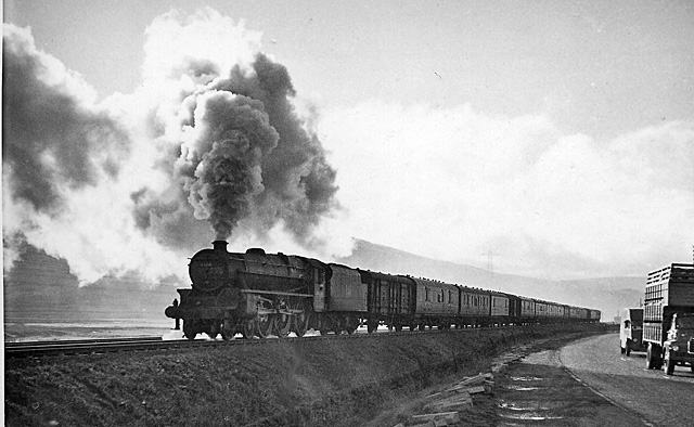
English: Nearing Beattock Summit from the north. View NW from the A74, towards Elvanfoot, Carstairs and Glasgow; ex-Caledonian West Coast Main Line, Carlisle - Carstairs - Glasgow/Edinburgh. The train is an Up parcels, headed by Stanier Class 5 4-6-0 No. 45018. The railway and road are here at over 1,000 feet just below Beattock Summit. The location is desolate and rain/wind-swept, but 'enlivened' by the trains on the railway and the lorries that choked the A74 before - ?since - its conversion to a Motorway. Over to the left is the valley of the Clyde Burn, which drains into the River Clyde. |
| Date | Taken on 27 September 1957 |
| Source | From geograph.org.uk |
| Author | Ben Brooksbank |
| Permission (Reusing this file) |
Creative Commons Attribution Share-alike license 2.0 |
| Camera location | | View this and other nearby images on: OpenStreetMap |
|---|
Licensing
[edit]

|
This image was taken from the Geograph project collection. See this photograph's page on the Geograph website for the photographer's contact details. The copyright on this image is owned by Ben Brooksbank and is licensed for reuse under the Creative Commons Attribution-ShareAlike 2.0 license.
|
This file is licensed under the Creative Commons Attribution-Share Alike 2.0 Generic license.
Attribution: Ben Brooksbank
- You are free:
- to share – to copy, distribute and transmit the work
- to remix – to adapt the work
- Under the following conditions:
- attribution – You must give appropriate credit, provide a link to the license, and indicate if changes were made. You may do so in any reasonable manner, but not in any way that suggests the licensor endorses you or your use.
- share alike – If you remix, transform, or build upon the material, you must distribute your contributions under the same or compatible license as the original.
File history
Click on a date/time to view the file as it appeared at that time.
| Date/Time | Thumbnail | Dimensions | User | Comment | |
|---|---|---|---|---|---|
| current | 14:59, 2 December 2010 | | 640 × 394 (110 KB) | Chevin (talk | contribs) | == {{int:filedesc}} == {{Information |Description={{en|1=Nearing Beattock Summit from the north View NW from the A74, towards Elvanfoot, Carstairs and Glasgow; ex-Caledonian West Coast Main Line, Carlisle - Carstairs - Glasgow/Edinburgh. The train is an U |
You cannot overwrite this file.
File usage on Commons
There are no pages that use this file.
File usage on other wikis
The following other wikis use this file:
- Usage on en.wikipedia.org