File:Banks-map-1938.jpg
Original file (911 × 506 pixels, file size: 99 KB, MIME type: image/jpeg)
Captions
Captions
Summary
[edit]
| Description |
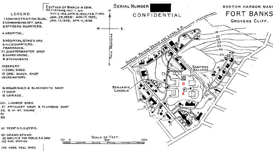
English: 1938 map of Ft. Banks shows the four mortar pits of Batteries Lincoln(on the west) and Kellogg (on the east) at the center of the map. The two northerly "B" pits (see red labels) each (by 1938) contained two mortars, while the southerly "A" pits contained four mortars each.
Today (2010), only Kellogg Pit B (the northeastern pit) is visible from the surface. The others have been filled in and/or built over. The site is now occupied by the Winthrop Dept. of Public Works and a private development of apartment buildings. The abandoned magazines of the fort are used for storage. The fort, established in 1890, contained 42.9 acres of land (as listed by the U.S. Army Engineers in 1945). Its mortar batteries were officially abandoned by the Coast Artillery on December 15, 1942. The fort was decommissioned in 1947.
|
||
| Date | (most recent update) | ||
| Source | U.S. Army Engineers, "Harbor Defenses of Boston" (maps of various dates) | ||
| Author | U.S. Army Engineers |
| Object location | | View this and other nearby images on: OpenStreetMap |
|---|
Red mortar pit labels added Pgrig (talk) 17:45, 8 July 2010 (UTC)
Licensing
[edit]
This work is in the public domain in the United States because it is a work prepared by an officer or employee of the United States Government as part of that person’s official duties under the terms of Title 17, Chapter 1, Section 105 of the US Code.
Note: This only applies to original works of the Federal Government and not to the work of any individual U.S. state, territory, commonwealth, county, municipality, or any other subdivision. This template also does not apply to postage stamp designs published by the United States Postal Service since 1978. (See § 313.6(C)(1) of Compendium of U.S. Copyright Office Practices). It also does not apply to certain US coins; see The US Mint Terms of Use.
|
 | |
| This file has been identified as being free of known restrictions under copyright law, including all related and neighboring rights. | ||
File history
Click on a date/time to view the file as it appeared at that time.
| Date/Time | Thumbnail | Dimensions | User | Comment | |
|---|---|---|---|---|---|
| current | 17:45, 8 July 2010 | | 911 × 506 (99 KB) | Pgrig (talk | contribs) | {{Information |Description={{en|1=1938 map of Ft. Banks shows the four mortar pits of Batteries Lincoln and Kellogg at center. The two northerly "B" pits (see red labels) each (by 1938) contained two mortars, while the southerly "A" pits contained four mo |
You cannot overwrite this file.
File usage on Commons
There are no pages that use this file.
File usage on other wikis
The following other wikis use this file:
- Usage on en.wikipedia.org