File:Bagratuni Armenia 1000-fr.svg
Jump to navigation
Jump to search

Size of this PNG preview of this SVG file: 800 × 470 pixels. Other resolutions: 320 × 188 pixels | 640 × 376 pixels | 1,024 × 601 pixels | 1,280 × 751 pixels | 2,560 × 1,503 pixels | 2,717 × 1,595 pixels.
Original file (SVG file, nominally 2,717 × 1,595 pixels, file size: 815 KB)
Captions
Captions
Add a one-line explanation of what this file represents
Summary
[edit]| Description |
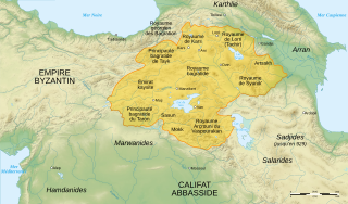
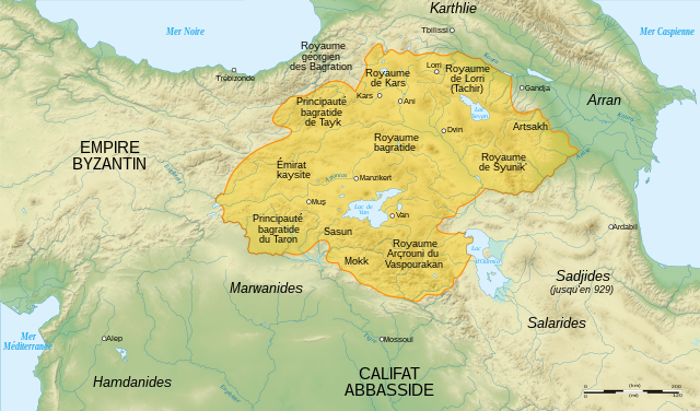
English: Map of Bagratuni Armenia, around the year 1000 AD., with French labels. (original map by G. A. Bournoutian from «A Concise History of the Armenian People», map 15, page 147) Français : Carte de l'Arménie bagratide vers l'an mille, . |
||
| Date | |||
| Source |
English: Data:
Softwares used :
Geographical data :
Français : Own work. Sources :
Logiciels utilisés :
Autres données :
|
||
| Author | Sémhur | ||
| Other versions |
[]
|
||
| Attribution (required by the license) | © Sémhur / Wikimedia Commons / | ||
| SVG | W3C-validity not checked.
|
||
| Atelier graphique |


| Camera location | | View this and other nearby images on: OpenStreetMap |
|---|
Licensing
[edit]
I, the copyright holder of this work, hereby publish it under the following licenses:
| Copyleft: This work of art is free; you can redistribute it and/or modify it according to terms of the Free Art License. You will find a specimen of this license on the Copyleft Attitude site as well as on other sites. |
This file is licensed under the Creative Commons Attribution-Share Alike 4.0 International, 3.0 Unported, 2.5 Generic, 2.0 Generic and 1.0 Generic license.
- You are free:
- to share – to copy, distribute and transmit the work
- to remix – to adapt the work
- Under the following conditions:
- attribution – You must give appropriate credit, provide a link to the license, and indicate if changes were made. You may do so in any reasonable manner, but not in any way that suggests the licensor endorses you or your use.
- share alike – If you remix, transform, or build upon the material, you must distribute your contributions under the same or compatible license as the original.
You may select the license of your choice.
File history
Click on a date/time to view the file as it appeared at that time.
| Date/Time | Thumbnail | Dimensions | User | Comment | |
|---|---|---|---|---|---|
| current | 16:22, 20 April 2021 | | 2,717 × 1,595 (815 KB) | Εὐθυμένης (talk | contribs) | File uploaded using svgtranslate tool (https://svgtranslate.toolforge.org/). Added translation for el. |
| 09:41, 19 March 2016 |  | 2,717 × 1,595 (775 KB) | Taivo (talk | contribs) | repeatedly uploaded unsourced version | |
| 23:00, 17 March 2016 |  | 2,717 × 1,595 (717 KB) | Georgiano (talk | contribs) | 1) https://fr.wikipedia.org/wiki/Royaume_des_Kartvels 2) check out land titles of Bagratuni dynasty 3) during VIII-X century Tao (historical region) was part of Kingdom of the Kartvels. before removing my update, add... | |
| 18:57, 26 December 2007 |  | 2,717 × 1,595 (775 KB) | Sémhur (talk | contribs) | {{Information |Description= {{en| French map of Bagratuni Armenia, around the year 1000 AD.}} {{fr| Carte en français de l'Arménie bagratide, vers l'an mille.}} |Source=Travail personnel. {{clr}} Sources : * Fond de carte : [http://www2.jpl.nasa.gov/srt |
You cannot overwrite this file.
File usage on Commons
The following 11 pages use this file:
- User:Chumwa/OgreBot/Potential transport maps/2016 March 11-20
- User:Jaqeli/Georgia
- User:Kareyac/Armenia/2016 March 11-20
- File:BagratuniArmenie1000.png
- File:Bagratuni Armenia 1000-ar.svg
- File:Bagratuni Armenia 1000-en.svg
- File:Bagratuni Armenia 1000-fr.svg
- File:Bagratuni Armenia 1000-hy.svg
- File:Bagratuni Armenia 1000-pt.svg
- File:Bagratuni Armenia 1000-tr.svg
- Template:Other Versions/Bagratuni Armenia 1000
File usage on other wikis
The following other wikis use this file:
- Usage on ce.wikipedia.org
- Usage on el.wikipedia.org
- Usage on fr.wikipedia.org
- Arménie
- Années 990
- Kars
- Bagratides
- Grégoire de Narek
- Histoire de l'Arménie médiévale
- Horomos
- Achot Ier d'Arménie
- Taron (Arménie)
- Vaspourakan
- Utilisateur:Hayastan07/Architecture arménienne
- Wikipédia:Atelier graphique/Cartes/Archives/janvier 2008
- Chronologie de l'Arménie
- Royaume de Lorri
- Miniature arménienne
- Wikipédia:Atelier graphique/Cartes/Archives/mars 2009
- Histoire de l'Arménie
- Conquête musulmane de l'Arménie
- Usage on it.wikipedia.org
- Usage on pcd.wikipedia.org
- Usage on ru.wikipedia.org
- Usage on uk.wikipedia.org
- Usage on zh.wikipedia.org