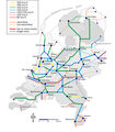
File:Baanvaksnelheden.png
From Wikimedia Commons, the free media repository
Jump to navigation
Jump to search

Size of this preview: 496 × 600 pixels. Other resolutions: 198 × 240 pixels | 397 × 480 pixels | 635 × 768 pixels | 1,187 × 1,435 pixels.
Original file (1,187 × 1,435 pixels, file size: 351 KB, MIME type: image/png)
File information
Structured data
Captions
Captions
Add a one-line explanation of what this file represents

|
File:Baanvaksnelheden.svg is a vector version of this file. It should be used in place of this PNG file when not inferior.
File:Baanvaksnelheden.png → File:Baanvaksnelheden.svg
For more information, see Help:SVG.
|
Summary
[edit]| DescriptionBaanvaksnelheden.png | Maximumspeeds of Dutch railways |
| Date | |
| Source | Data are from http://www.hans-marijnissen.com/baanvaksnelheid.htm (nu op http://www.spoorsite-twente.net/informatie/bv/baanvakken.htm) and http://www.prorail.nl/NR/rdonlyres/4791FAB2-85FC-43D2-9386-85F41AD9BAC1/0/Spoorwegnet.pdf. http://www.sp.nl/verkeer/nieuwsberichten/8025/101007-verhoog_snelheid_spoor_amsterdam_utrecht_tot_200_kilometer_per_uur.html explains the line Utrecht-Amsterda will for the moment not be 200 km/h; it remains at 160 km/h. |
| Author | MJSmit |
Licensing
[edit]| Public domainPublic domainfalsefalse |
| I, the copyright holder of this work, release this work into the public domain. This applies worldwide. In some countries this may not be legally possible; if so: I grant anyone the right to use this work for any purpose, without any conditions, unless such conditions are required by law. |
File history
Click on a date/time to view the file as it appeared at that time.
| Date/Time | Thumbnail | Dimensions | User | Comment | |
|---|---|---|---|---|---|
| current | 10:44, 17 October 2012 |  | 1,187 × 1,435 (351 KB) | Classical geographer (talk | contribs) | Hanzelijn now completed (even though still without traffic). Changed colours slightly, notably making the HSL-Zuid red, and the slowest lines black. Amsterdam-Utrecht still 160 km/h; upgrade to 200 km/h now in doubt, as explained at http://www.sp.nl/ve... |
| 21:48, 5 August 2010 |  | 1,265 × 1,529 (352 KB) | AgentX~commonswiki (talk | contribs) | Reverted to version as of 20:40, 27 July 2009 | |
| 21:46, 5 August 2010 |  | 1,265 × 1,529 (317 KB) | AgentX~commonswiki (talk | contribs) | ||
| 20:40, 27 July 2009 |  | 1,265 × 1,529 (352 KB) | Classical geographer (talk | contribs) | Newly added links are non-electrified. Also changed background from blurry image to fresh new image. (Actually, File:Blank map of the Netherlands.svg.) I also discovered the line from Heerlen towards Aken is non-electrified, judging from [[:File:Sta | |
| 19:45, 27 July 2009 |  | 1,743 × 1,986 (899 KB) | Classical geographer (talk | contribs) | Several small fixed: * moved some stations to better locations * removed some small stations (without labels) that are not end-points or really important junctions; I'm considering whether to label them and, importantly, * added Betuweroute * added inte | |
| 08:20, 11 July 2009 |  | 1,394 × 1,588 (639 KB) | Classical geographer (talk | contribs) | Moved Enkhuizen onto land. Also adjusted Lelystad and (invisible) Meppel somehwat. | |
| 17:24, 8 April 2009 |  | 1,573 × 1,942 (1.08 MB) | T Houdijk (talk | contribs) | More changes; Zutphen-Hengelo is non-electrified | |
| 20:36, 20 February 2009 |  | 1,573 × 1,942 (1.19 MB) | Classical geographer (talk | contribs) | Another change: Leeuwarden-Groningen 140 km/h all the way, instead of only the double-track section. Also added scale and north arrow. | |
| 15:13, 15 March 2008 |  | 1,743 × 1,986 (352 KB) | T Houdijk (talk | contribs) | Fixed a few errors in this map. | |
| 16:15, 3 December 2007 |  | 1,743 × 1,986 (528 KB) | Classical geographer (talk | contribs) |
You cannot overwrite this file.
File usage on Commons
The following page uses this file:
File usage on other wikis
The following other wikis use this file:
- Usage on de.wikipedia.org
- Usage on en.wikipedia.org
- Usage on es.wikipedia.org
- Usage on fr.wikipedia.org
- Usage on hu.wikipedia.org
- Usage on ja.wikipedia.org
- Usage on nl.wikipedia.org
- Usage on sv.wikipedia.org
Metadata
This file contains additional information such as Exif metadata which may have been added by the digital camera, scanner, or software program used to create or digitize it. If the file has been modified from its original state, some details such as the timestamp may not fully reflect those of the original file. The timestamp is only as accurate as the clock in the camera, and it may be completely wrong.
| Horizontal resolution | 118.11 dpc |
|---|---|
| Vertical resolution | 118.11 dpc |
