File:BNE.Barcelona.planos.1806.jpg
Jump to navigation
Jump to search

Size of this preview: 800 × 561 pixels. Other resolutions: 320 × 224 pixels | 640 × 449 pixels | 1,024 × 718 pixels | 1,280 × 898 pixels | 2,871 × 2,014 pixels.
Original file (2,871 × 2,014 pixels, file size: 2.78 MB, MIME type: image/jpeg)
Captions
Captions
Add a one-line explanation of what this file represents
Summary
[edit]
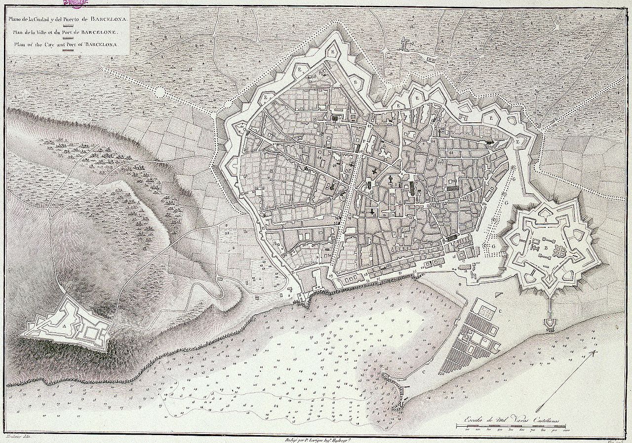
- Lugar geogr.: Barcelona. Planos de población. 1806?
- Autores Secun: Lartigne, Pierre. Vicq (fl. 1806-1820). Moulinier, Jacques (1753-1828)
- Título:
{spanish} Plano de la Ciudad y del Puerto de Barcelona {french} Plan de la ville et du Port de Barcelone {english} Plan of the City and Port of Barcelona
- Escala: Escala [ca. 1:11.000]. 1000 varas castellanas [= 7,5 cm]
- Publicación: [S.l. : s.n., 1806
- Descripción: 1 plano : grab. ; 33 x 46 cm
- Notas: Pertenece a: "Voyage de l`Espagne" por Alexandre de Laborde. - París, 1806-1820 Orientado con flecha con el N. al NE. del plano.- Cultivos y arbolado representados. - Sondas. - Relieve por sombreado
Licensing
[edit]
|
This work is in the public domain in its country of origin and other countries and areas where the copyright term is the author's life plus 70 years or fewer. | |
| This file has been identified as being free of known restrictions under copyright law, including all related and neighboring rights. | |
File history
Click on a date/time to view the file as it appeared at that time.
| Date/Time | Thumbnail | Dimensions | User | Comment | |
|---|---|---|---|---|---|
| current | 03:44, 19 March 2006 | | 2,871 × 2,014 (2.78 MB) | Josep Panadero (talk | contribs) | [http://www.bne.es/ BNE] *Lugar geogr.: Barcelona. Planos de población. 1806? *Autores Secun: Lartigne, Pierre. Vicq (fl. 1806-1820). Moulinier, Jacques (1753-1828) *Título: {spanish} Plano de la Ciudad y del Puerto de Barcelona {french} Plan de la v |
You cannot overwrite this file.
File usage on Commons
The following page uses this file:
File usage on other wikis
The following other wikis use this file:
- Usage on ar.wikipedia.org
- Usage on ca.wikipedia.org
- 1806
- Parc de la Ciutadella
- Fortalesa de la Ciutadella
- Pla Cerdà
- Història de Barcelona
- Viquiprojecte:Tricentenari
- Muralles de Barcelona
- Exili austriacista
- Repressió borbònica en la Guerra de Successió Espanyola
- Regència d'Espartero
- Urbanisme de Barcelona
- Epidèmia de febre groga de 1821
- Enginyeria urbana
- Usage on de.wikipedia.org
- Usage on en.wikipedia.org
- Usage on es.wikipedia.org
- Usage on fr.wikipedia.org
- Usage on gl.wikipedia.org
- Usage on he.wikipedia.org
- Usage on ja.wikipedia.org
- Usage on oc.wikipedia.org
- Usage on pt.wikipedia.org
- Usage on sv.wikipedia.org
- Usage on www.wikidata.org