File:Atlas von Asien (15177001).jpg
From Wikimedia Commons, the free media repository
Jump to navigation
Jump to search

Size of this preview: 493 × 600 pixels. Other resolutions: 197 × 240 pixels | 394 × 480 pixels | 631 × 768 pixels | 842 × 1,024 pixels | 1,683 × 2,048 pixels | 5,293 × 6,439 pixels.
Original file (5,293 × 6,439 pixels, file size: 10.05 MB, MIME type: image/jpeg)
File information
Structured data
Captions
Captions
Add a one-line explanation of what this file represents
Summary
[edit]| DescriptionAtlas von Asien (15177001).jpg |
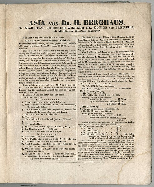
Deutsch: Atlas von Asien.
English: Atlas of Asia. Of the original 18 maps announced (number 19 should be 18) only 15 were ever published and these three were never completed: No. 1 - Generalkarte von Asia, No. 3 - Das Westliche Hochasia, No. 4 - Die Halbinsel von Kleinasia [Turkey]. While financially the atlas was a failure, the cartography was outstanding and made Justus Perthes world famous instantly. These are the largest and best German maps of that era and area - published by Justus Perthes in Gotha. |
|||||||||||||||||||||||||||||||||||||||||||||
| Date | ||||||||||||||||||||||||||||||||||||||||||||||
| Source | list, main | |||||||||||||||||||||||||||||||||||||||||||||
| Author |
creator QS:P170,Q67485
creator QS:P170,Q61973017 |
|||||||||||||||||||||||||||||||||||||||||||||
Licensing
[edit]|
This is a faithful photographic reproduction of a two-dimensional, public domain work of art. The work of art itself is in the public domain for the following reason:
The official position taken by the Wikimedia Foundation is that "faithful reproductions of two-dimensional public domain works of art are public domain".
This photographic reproduction is therefore also considered to be in the public domain in the United States. In other jurisdictions, re-use of this content may be restricted; see Reuse of PD-Art photographs for details. | |||||
File history
Click on a date/time to view the file as it appeared at that time.
| Date/Time | Thumbnail | Dimensions | User | Comment | |
|---|---|---|---|---|---|
| current | 09:38, 18 July 2023 |  | 5,293 × 6,439 (10.05 MB) | YannBot (talk | contribs) | == {{int:filedesc}} == {{Information |Description={{de|1=''Atlas von Asien''.}} {{en|1=Atlas of Asia. Of the original 18 maps announced (number 19 should be 18) only 15 were ever published and these three were never completed: No. 1 - ''Generalkarte von Asia'', No. 3 - ''Das Westliche Hochasia'', No. 4 - ''Die Halbinsel von Kleinasia'' [Turkey]. While financially the atlas was a failure, the cartography was outstanding and made Justus Perthes world famous instantly. These are the largest and... |
You cannot overwrite this file.
File usage on Commons
There are no pages that use this file.
