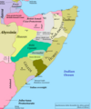
File:Anachronous latter scramble for Africa period, Horn of Africa.png

Original file (1,110 × 1,327 pixels, file size: 220 KB, MIME type: image/png)
Captions
Captions
Summary
[edit]| DescriptionAnachronous latter scramble for Africa period, Horn of Africa.png |
English: Anachronous latter scramble for Africa period, Horn of Africa |
| Date | |
| Source |
Data for this map is derived from several sources: Biimaal movement in the Collapse of The Somali State, Abdisalam Salwe, page 22; The southern Shirmo / Borderlands, in Douglas Jardine 1923, in the paragraphs containing "always been accursed , a no-man's land populated by fanatical Ogaden tribes", page 285, The northern bondary between British and buffer zone can be found in the text "An imaginary line was drawn roughly from Ankhor on the sea-coast through Eil Dur Elan to Badwein" The northern Dervish border can be found in the text "nearest dervish post was now at Jidali" (The King's African Rifles, Moyse-Bartlett, Page 421), the western and eastern Dervish borders as Tifafle & Do'mo and Ras Garad and Ras Gabbe respectively in the text "they are the wells of Halin , and from these to those of Hudin , and from Hudin to Tifafle , and from Tifafle to Damot" (British and Foreign State Papers, page 548) Hormadiid territory in the text "waxaana degganaa oo u talinaayey niman xoog leh oo la oran jirey Hormadiid", (page 220, Jaamac Cumar Ciise) ; Xassan Barsane core territories in (Putting the Cart Before the Horse, Abdi Kusow, page 87), Huwan territories in the foreword containing " Huwan oo dadkii Mililiq iyo amxaaro raacay ahaa, Adarina laga maamulayey" (poem 80, Diiwaanka gabayadii, 1856-1921) The demarcations for Jubaland Protectorate and Italian oversighted Sultanates can be found in the various images of epilogues and postfaces of books by Caroselli, Francesco Saverio. Overview of the status and demarcations of the non-Protectorate British Somali Coast tribes can be found at (British and Foreign State Papers, page 103, year 1892) |
| Author | Bulllinzoneownere |
Licensing
[edit]| This file is made available under the Creative Commons CC0 1.0 Universal Public Domain Dedication. | |
| The person who associated a work with this deed has dedicated the work to the public domain by waiving all of their rights to the work worldwide under copyright law, including all related and neighboring rights, to the extent allowed by law. You can copy, modify, distribute and perform the work, even for commercial purposes, all without asking permission.
http://creativecommons.org/publicdomain/zero/1.0/deed.enCC0Creative Commons Zero, Public Domain Dedicationfalsefalse |
File history
Click on a date/time to view the file as it appeared at that time.
| Date/Time | Thumbnail | Dimensions | User | Comment | |
|---|---|---|---|---|---|
| current | 23:49, 4 June 2023 |  | 1,110 × 1,327 (220 KB) | Bulllinzoneownere (talk | contribs) | hormadiid |
| 05:40, 4 June 2023 |  | 1,110 × 1,327 (221 KB) | Bulllinzoneownere (talk | contribs) | webi | |
| 19:39, 27 May 2023 |  | 1,110 × 1,327 (220 KB) | Bulllinzoneownere (talk | contribs) | Uploaded own work with UploadWizard |
You cannot overwrite this file.
File usage on Commons
There are no pages that use this file.
File usage on other wikis
The following other wikis use this file:
Metadata
This file contains additional information such as Exif metadata which may have been added by the digital camera, scanner, or software program used to create or digitize it. If the file has been modified from its original state, some details such as the timestamp may not fully reflect those of the original file. The timestamp is only as accurate as the clock in the camera, and it may be completely wrong.
| Horizontal resolution | 47.24 dpc |
|---|---|
| Vertical resolution | 47.24 dpc |