File:Alaska boroughs and census areas in color.png
Jump to navigation
Jump to search
No higher resolution available.
Alaska_boroughs_and_census_areas_in_color.png (356 × 262 pixels, file size: 8 KB, MIME type: image/png)
Captions
Captions
Add a one-line explanation of what this file represents
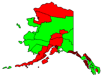
| Description | Map of boroughs and census areas in the U.S. state of Alaska. Green areas are census areas, brown are consolidated city-boroughs, and red are other boroughs. | ||||||||
| Date | Originally uploaded on 24 January 2008 (with slightly different name; an upload problem led to the new name), with modification on 12 August 2008 to show Skagway Borough | ||||||||
| Source | Modified from Image:Map of USA with county outlines.png | ||||||||
| Author | Nyttend | ||||||||
| Permission (Reusing this file) |
because of source; my changes are {{PD-self}} |

File history
Click on a date/time to view the file as it appeared at that time.
| Date/Time | Thumbnail | Dimensions | User | Comment | |
|---|---|---|---|---|---|
| current | 03:01, 12 August 2008 | | 356 × 262 (8 KB) | Nyttend (talk | contribs) | {{Information |Description=Map of {{w|List of boroughs and census areas in Alaska|boroughs and census areas}} in the {{w|U.S. state}} of {{w|Alaska}}. Green areas are census areas, brown are {{w|consolidated city-county|consolidated city-boroughs}}, and |
You cannot overwrite this file.
File usage on Commons
There are no pages that use this file.
File usage on other wikis
The following other wikis use this file:
- Usage on de.wikipedia.org
- Usage on en.wikipedia.org
- Usage on id.wikipedia.org
- Usage on sq.wikipedia.org