File:Agressão da mata do Iguatemí por atividades antrópicas.jpg
Jump to navigation
Jump to search

Size of this preview: 800 × 539 pixels. Other resolutions: 320 × 216 pixels | 640 × 431 pixels | 1,024 × 690 pixels | 1,280 × 863 pixels | 1,682 × 1,134 pixels.
Original file (1,682 × 1,134 pixels, file size: 1.94 MB, MIME type: image/jpeg)
Captions
Captions
Add a one-line explanation of what this file represents
Summary
[edit]
| Description |
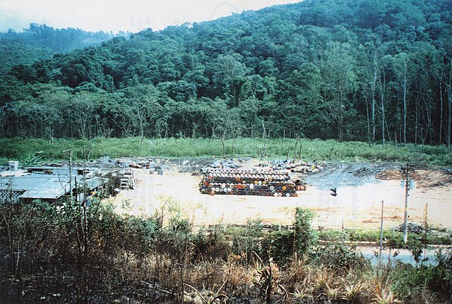
Português: Os tambores estão dispostos no centro do terreno encontravam-se preparados para sua comercialização. No fundo do lote, observa-se a mata da APA da Mata do Iguatemí com árvores secas e severamente impactadas pelos contaminantes presentes nas borras industriais descartadas dos tambores e bombonas para sua recuperação e revenda. English: The drums are arranged in the center of the plot and were prepared for sale. At the back of the plot, you can see the of the Iguatemí Forest APA can be seen, with dry trees that have been severely impacted by the contaminants by the contaminants present in the industrial sludge discarded from the drums for recovery and resale. Special Awards: |
| Date | |
| Source | Own work |
| Author | Rosa Helena Cavalheiro Viadana |
| Camera location | | View this and other nearby images on: OpenStreetMap |
|---|
Licensing
[edit]
I, the copyright holder of this work, hereby publish it under the following license:
This file is licensed under the Creative Commons Attribution-Share Alike 4.0 International license.
- You are free:
- to share – to copy, distribute and transmit the work
- to remix – to adapt the work
- Under the following conditions:
- attribution – You must give appropriate credit, provide a link to the license, and indicate if changes were made. You may do so in any reasonable manner, but not in any way that suggests the licensor endorses you or your use.
- share alike – If you remix, transform, or build upon the material, you must distribute your contributions under the same or compatible license as the original.
This image was uploaded as part of Wiki Loves Earth 2022.
|
 |
File history
Click on a date/time to view the file as it appeared at that time.
| Date/Time | Thumbnail | Dimensions | User | Comment | |
|---|---|---|---|---|---|
| current | 04:30, 4 August 2022 | | 1,682 × 1,134 (1.94 MB) | Rosa Helena Cavalheiro Viadana (talk | contribs) | Uploaded own work with UploadWizard |
You cannot overwrite this file.
File usage on Commons
The following page uses this file: