File:Africa map political 1929.jpg
Jump to navigation
Jump to search

Size of this preview: 468 × 600 pixels. Other resolutions: 187 × 240 pixels | 375 × 480 pixels | 599 × 768 pixels | 799 × 1,024 pixels | 1,598 × 2,048 pixels | 8,517 × 10,912 pixels.
Original file (8,517 × 10,912 pixels, file size: 124.32 MB, MIME type: image/jpeg)
Captions
Captions
Add a one-line explanation of what this file represents
Summary
[edit]
| Warning | The original file is very high-resolution. It might not load properly or could cause your browser to freeze when opened at full size. |
|---|
| Description |
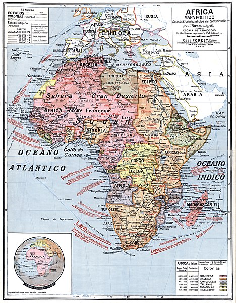
English: Map of Africa in 1929 showing exports |
|||||||||
| Date | ||||||||||
| Source | Gallica | |||||||||
| Creator |
J Forest |
|||||||||
| Geotemporal data | ||||||||||
| Bounding box |
|
|||||||||
| Georeferencing | ||||||||||
Licensing
[edit]
|
This work is in the public domain in its country of origin and other countries and areas where the copyright term is the author's life plus 70 years or fewer. | |
| This file has been identified as being free of known restrictions under copyright law, including all related and neighboring rights. | |
File history
Click on a date/time to view the file as it appeared at that time.
| Date/Time | Thumbnail | Dimensions | User | Comment | |
|---|---|---|---|---|---|
| current | 13:40, 4 September 2018 | | 8,517 × 10,912 (124.32 MB) | Shyamal (talk | contribs) | User created page with UploadWizard |
You cannot overwrite this file.
File usage on Commons
There are no pages that use this file.