File:Access to the tram stop - geograph.org.uk - 4161705.jpg
Jump to navigation
Jump to search

Size of this preview: 800 × 598 pixels. Other resolutions: 320 × 239 pixels | 640 × 478 pixels | 1,024 × 765 pixels | 1,280 × 956 pixels.
Original file (1,280 × 956 pixels, file size: 327 KB, MIME type: image/jpeg)
Captions
Captions
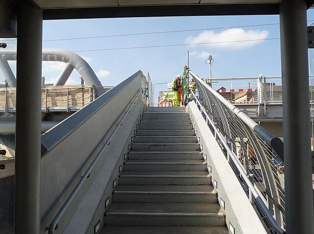
Interchange between trains and trams at the main station in the English city of Nottingham. This staircase used to link the railway station's East Footbridge to the former tram terminus at Station Street across a now-demolished footbridge ...
Summary
[edit]
| Description |
English: Interchange between trains and trams at the main station in the English city of Nottingham. This staircase used to link the railway station's East Footbridge to the former tram terminus at Station Street across a footbridge to the right at the top of the stairs. At the time this photo was taken, the footbridge had been demolished to be replaced by the, still under construction, Karlsruhe Friendship Bridge, and that access reinstated across the unfinished bridge. Since then the tramway has been extended across the bridge, and the Station Street tram stop replaced with a new stop at the station. The stairs now connect to the new station tram stop, to the left at the top of the stairs, although that stop has a much more direct (and accessible) connection to the station at its other end. Turning right at the top of the stairs now gives access to the lift and stairs down to the other side of Station Street that were once the principal access to the tram terminus although, as that stretch of Station Street has since been pedestrianised, that would be a pretty pointless routing. |
| Date | Taken on 8 September 2014 |
| Source | From geograph.org.uk |
| Author | Alan Murray-Rust |
| Permission (Reusing this file) |
Creative Commons Attribution Share-alike license 2.0 |
| Attribution (required by the license) | Alan Murray-Rust / Access to the tram stop / |
| Camera location | | View this and other nearby images on: OpenStreetMap |
|---|
_heading:270.00&language=en)
| Object location | | View this and other nearby images on: OpenStreetMap |
|---|
_heading:270.00&language=en)
Licensing
[edit]

|
This image was taken from the Geograph project collection. See this photograph's page on the Geograph website for the photographer's contact details. The copyright on this image is owned by Alan Murray-Rust and is licensed for reuse under the Creative Commons Attribution-ShareAlike 2.0 license.
|
This file is licensed under the Creative Commons Attribution-Share Alike 2.0 Generic license.
Attribution: Alan Murray-Rust
- You are free:
- to share – to copy, distribute and transmit the work
- to remix – to adapt the work
- Under the following conditions:
- attribution – You must give appropriate credit, provide a link to the license, and indicate if changes were made. You may do so in any reasonable manner, but not in any way that suggests the licensor endorses you or your use.
- share alike – If you remix, transform, or build upon the material, you must distribute your contributions under the same or compatible license as the original.
File history
Click on a date/time to view the file as it appeared at that time.
| Date/Time | Thumbnail | Dimensions | User | Comment | |
|---|---|---|---|---|---|
| current | 13:21, 20 December 2022 | | 1,280 × 956 (327 KB) | GeographBot (talk | contribs) | Uploading geograph.org.uk image from https://www.geograph.org.uk/photo/4161705 |
You cannot overwrite this file.
File usage on Commons
There are no pages that use this file.