File:A mapp of New England (2675735796).jpg
Jump to navigation
Jump to search

Size of this preview: 720 × 599 pixels. Other resolutions: 288 × 240 pixels | 577 × 480 pixels | 923 × 768 pixels | 1,230 × 1,024 pixels | 2,000 × 1,665 pixels.
Original file (2,000 × 1,665 pixels, file size: 2.83 MB, MIME type: image/jpeg)
Captions
Captions
Add a one-line explanation of what this file represents
Summary
[edit].jpg&action=edit§ion=1)
| Description |
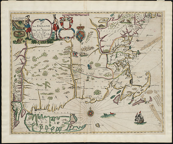
Zoom into this map at maps.bpl.org. Author: Seller, John Publisher: And are to bee sold at his shop at the Hermitage in Wapping and by Iohn Hills in Exchange Alley in Cornhill Date: [1675] Location: New England Scale: Scale [ca. 1:1,170,000]. Call Number: G3720 1675.S451 A foundation in the early history of the mapping of New England, this map is the first printed version of William Reed's original survey of 1665. The survey was commissioned by Massachusetts authorities to support the colonial boundaries as described in the first Massachusetts Charter of 1628. As originally proposed, the northern boundary was located thirty miles north of the Merrimack River, assuming the river followed an east-west course. When it was later discovered that inland the Merrimack River turned north, Massachusetts colonists aggressively claimed lands thirty miles north of the rivers source, an area also claimed by New Hampshire. The survey is the earliest to depict the relative position of the Hudson, Connecticut and Merrimack rivers. Also identified on the map are several towns that had beendestroyed by Indians during the early months of King Philip's War. |
| Date | |
| Source | A mapp of New England / |
| Author | http://maps.bpl.org |
Licensing
[edit].jpg&action=edit§ion=2)
This file is licensed under the Creative Commons Attribution 2.0 Generic license.
- You are free:
- to share – to copy, distribute and transmit the work
- to remix – to adapt the work
- Under the following conditions:
- attribution – You must give appropriate credit, provide a link to the license, and indicate if changes were made. You may do so in any reasonable manner, but not in any way that suggests the licensor endorses you or your use.
| This image, originally posted to Flickr, was reviewed on 21 August 2013 by the administrator or reviewer File Upload Bot (Magnus Manske), who confirmed that it was available on Flickr under the stated license on that date. |
File history
Click on a date/time to view the file as it appeared at that time.
| Date/Time | Thumbnail | Dimensions | User | Comment | |
|---|---|---|---|---|---|
| current | 04:37, 21 August 2013 | | 2,000 × 1,665 (2.83 MB) | File Upload Bot (Magnus Manske) (talk | contribs) | Transferred from Flickr by User:tm |
You cannot overwrite this file.
File usage on Commons
There are no pages that use this file.
File usage on other wikis
The following other wikis use this file:
- Usage on ru.wikipedia.org
.jpg&oldid=917724882)