File:ATB-kaart.png
From Wikimedia Commons, the free media repository
Jump to navigation
Jump to search
ATB-kaart.png (450 × 522 pixels, file size: 26 KB, MIME type: image/png)
File information
Structured data
Captions
Captions
Add a one-line explanation of what this file represents
Summary
[edit]
|
This transport map image could be re-created using vector graphics as an SVG file. This has several advantages; see Commons:Media for cleanup for more information. If an SVG form of this image is available, please upload it and afterwards replace this template with
{{vector version available|new image name}}.
It is recommended to name the SVG file “ATB-kaart.svg”—then the template Vector version available (or Vva) does not need the new image name parameter. |
| DescriptionATB-kaart.png |
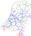
Nederlands: spoorkaart van Nederland. toont waar ATB-EG, ATB-NG en PZB of geen treinbeïnvloeding ligt, eigen werk, nl:categorie:Kaart
English: Map of the railways in the Netherlands, which shows the lines where different train protection systems are in use. |
| Date | 24 May 2004 (original upload date) |
| Source | Transferred from nl.wikipedia to Commons. |
| Author |
LennartBolks at Dutch Wikipedia Later versions were uploaded by Asierts, Maartenvdbent at nl.wikipedia. |
Licensing
[edit]| Public domainPublic domainfalsefalse |
| This work has been released into the public domain by its author, LennartBolks at Dutch Wikipedia. This applies worldwide. In some countries this may not be legally possible; if so: LennartBolks grants anyone the right to use this work for any purpose, without any conditions, unless such conditions are required by law.Public domainPublic domainfalsefalse |
Original upload log
[edit]The original description page was here. All following user names refer to nl.wikipedia.
- 2006-12-05 05:26 Maartenvdbent 450×522×8 (14289 bytes) ATB+ duidelijker
- 2006-11-04 20:15 Asierts 450×522×8 (15836 bytes) spoorkaart van Nederland. toont waar ATB-EG, ATB-NG en PZB of geen treinbeïnvloeding ligt, eigen werk, {{msg:PD}} [[categorie:Kaart]]
- 2006-11-04 19:32 Asierts 450×522×8 (15814 bytes) spoorkaart van Nederland. toont waar ATB-EG, ATB-NG en PZB of geen treinbeïnvloeding ligt, eigen werk, {{msg:PD}} [[categorie:Kaart]]
- 2004-07-15 17:24 LennartBolks 450×522×8 (41938 bytes) grensbaanvakken gewijzigd
- 2004-05-24 20:34 LennartBolks 450×522×8 (41902 bytes) spoorkaart van Nederland. toont waar ATB-EG, ATB-NG en PZB of geen treinbeïnvloeding ligt, eigen werk, {{msg:PD}}
File history
Click on a date/time to view the file as it appeared at that time.
| Date/Time | Thumbnail | Dimensions | User | Comment | |
|---|---|---|---|---|---|
| current | 19:44, 16 June 2015 |  | 450 × 522 (26 KB) | Wim1234567890 (talk | contribs) | ERMTS Kijhoek en Zevenaar - Emmerich |
| 11:29, 23 December 2012 |  | 450 × 522 (31 KB) | Wim1234567890 (talk | contribs) | Sloenlijn en Zeeuwsvlaanderen toegevoegd. | |
| 11:27, 23 December 2012 |  | 450 × 522 (31 KB) | Wim1234567890 (talk | contribs) | Sloelijn en Terneuzenlijn toegevoegd, en 20 km buitenland. | |
| 11:24, 23 December 2012 |  | 450 × 522 (31 KB) | Wim1234567890 (talk | contribs) | Sloelijn etc. en 20 km buitenland toegevoegd. | |
| 09:51, 15 September 2012 |  | 450 × 522 (14 KB) | Hippolyte~commonswiki (talk | contribs) | ...forgot to update a small bit of the Amsterdam-Utrecht railway... | |
| 09:17, 15 September 2012 |  | 450 × 522 (14 KB) | Hippolyte~commonswiki (talk | contribs) | Changed colour of ETCS (two shades of green were very hard to distinguish) | |
| 22:34, 17 September 2008 |  | 450 × 522 (18 KB) | Pbech (talk | contribs) | Major correction: Hoorn-Medemblik. Made other "red" lines more of equal thickness. | |
| 20:27, 29 March 2007 |  | 450 × 522 (14 KB) | SieBot (talk | contribs) | {{Information |Description=spoorkaart van Nederland. toont waar ATB-EG, ATB-NG en PZB of geen treinbeïnvloeding ligt, eigen werk, nl:categorie:Kaart |Source=Originally from [http://nl.wikipedia.org nl.wikipedia]; description page is/was [http://n |
You cannot overwrite this file.
File usage on Commons
The following 3 pages use this file:
File usage on other wikis
The following other wikis use this file:
- Usage on hu.wikipedia.org
- Usage on ko.wikipedia.org
- Usage on nl.wikipedia.org
Metadata
This file contains additional information such as Exif metadata which may have been added by the digital camera, scanner, or software program used to create or digitize it. If the file has been modified from its original state, some details such as the timestamp may not fully reflect those of the original file. The timestamp is only as accurate as the clock in the camera, and it may be completely wrong.
| Horizontal resolution | 28.33 dpc |
|---|---|
| Vertical resolution | 28.33 dpc |
| File change date and time | 09:49, 15 September 2012 |
| Software used |
