File:AN ARCHAEOLOGICAL SITE CALLED THE BOTZUM MOUND WITH A DATE OF 500 B.C., ACCORDING TO THE CLEVELAND MUSEUM OF NATURAL... - NARA - 558101.jpg

Original file (3,000 × 2,030 pixels, file size: 1.02 MB, MIME type: image/jpeg)
Captions
Captions
Summary
[edit]| Author |
Frank J. (Frank John) Aleksandrowicz, 1921-, Photographer (NARA record: 8452210) |
||||||||||||||||||||||||||
| Record creator | Environmental Protection Agency. (12/02/1970 - ) | ||||||||||||||||||||||||||
| Title |
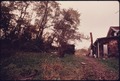
AN ARCHAEOLOGICAL SITE CALLED THE BOTZUM MOUND WITH A DATE OF 500 B.C., ACCORDING TO THE CLEVELAND MUSEUM OF NATURAL HISTORY IS SEEN AT THE LEFT OF THE PHOTO AT RIVERVIEW ROAD SOUTH OF BATH ROAD AT NORTHAMPTON NEAR AKRON, OHIO. THE AREA IS RICH IN INDIAN HISTORY THE NEARBY CUYAHOGA RIVER WAS A MAJOR TRANSPORTATION ARTERY FOR THEM AS WELL AS SETTLERS WHO PUSHED INTO THE AREA IN THE 19TH CENTURY. THE RIVER PROVIDED WATER FOR THE OHIO-ERIE CANAL BUILT BETWEEN 1825 AND 1827 |
||||||||||||||||||||||||||
| Depicted place |
Northampton Center (Summit county, Ohio, United States, North and Central America) inhabited place (41°09′00″N 81°31′59″W / 41.15°N 81.533°W; NARA geographical record) |
||||||||||||||||||||||||||
| Date | September 1975 | ||||||||||||||||||||||||||
| Collection |
|
||||||||||||||||||||||||||
| Record ID |
NAIL Control Number: NWDNS-412-DA-15651
|
||||||||||||||||||||||||||
| Source | U.S. National Archives and Records Administration | ||||||||||||||||||||||||||
| Other versions |
Please do not overwrite this file: any restoration work should be uploaded with a new name and linked in this page's "other versions=" parameter, so that this file represents the exact file found in the NARA catalog record to which it links. The metadata on this page was imported directly from NARA's catalog record; additional descriptive text may be added by Wikimedians to the template below with the "description=" parameter, but please do not modify the other fields.
|
||||||||||||||||||||||||||


Licensing
[edit]
This file was provided to Wikimedia Commons by the National Archives and Records Administration as part of a cooperation project. The National Archives and Records Administration provides images depicting American and global history which are public domain or licensed under a free license.
|
This image (or other media) is a work of an Environmental Protection Agency employee, taken or made as part of that person's official duties. As works of the U.S. federal government, all EPA images are in the public domain.
|
||
File history
Click on a date/time to view the file as it appeared at that time.
| Date/Time | Thumbnail | Dimensions | User | Comment | |
|---|---|---|---|---|---|
| current | 04:52, 20 October 2011 | | 3,000 × 2,030 (1.02 MB) | US National Archives bot (talk | contribs) | == {{int:filedesc}} == {{NARA-image-full | Title = AN ARCHAEOLOGICAL SITE CALLED THE BOTZUM MOUND WITH A DATE OF 500 B.C., ACCORDING TO THE CLEVELAND MUSEUM OF NATURAL HISTORY IS SEEN AT THE LEFT OF THE PHOTO AT RIVERVIEW ROAD SOUTH OF |
You cannot overwrite this file.
File usage on Commons
The following 2 pages use this file: