File:AMH-7751-KB Map of Chile.jpg

Original file (2,400 × 1,814 pixels, file size: 1 MB, MIME type: image/jpeg)
Captions
Captions
Summary
[edit]Nederlands: Kaart van Chili
English: Map of Chile( |
||||||||||||||||||||||||||||||||||||||||||||||||||
|---|---|---|---|---|---|---|---|---|---|---|---|---|---|---|---|---|---|---|---|---|---|---|---|---|---|---|---|---|---|---|---|---|---|---|---|---|---|---|---|---|---|---|---|---|---|---|---|---|---|---|
| Author |
Nederlands: Joan Blaeu sr. (uitgever), Wilhelm (Jansz.) Blaeu (uitgever), Anoniem / Anonymous (landmeter / kaartenmaker)
English: Joan Blaeu sr. (publisher), Wilhelm (Jansz.) Blaeu (publisher), Anoniem / Anonymous (land surveyor / mapmaker) |
|||||||||||||||||||||||||||||||||||||||||||||||||
| Title |
Nederlands: Kaart van Chili
English: Map of Chile |
|||||||||||||||||||||||||||||||||||||||||||||||||
| Description |
Nederlands: Kaart van Chili.
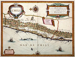
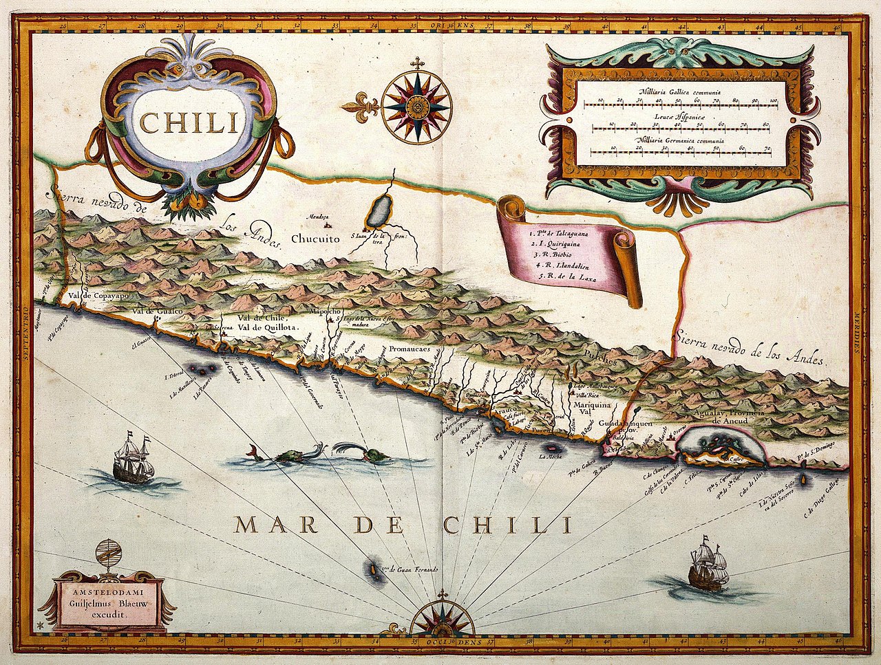
Chili. Willem Jansz. Blaeu (1571-1638) publiceerde deze kaart van Chili in zijn 'Appendix atlas' uit 1630. De gegevens voor het samenstellen van deze kaart, èn alle andere kaarten van Zuid-Amerika in de atlas, nam Blaeu over van Johannes de Laets (1583-1649) 'Beschrijvinghe van West-Indien' uit 1625. De kaart is later ook afgedrukt in Caspar Barlaeus' 'Rerum per octennium in Brasilia' in 1647 en de 'Atlas Maior' van 1665. Blaeu voegde aan de kaart van De Laet onder andere de cartouche rechtsonderin en de oostindiëvaarders toe. Legenda: 1. Pta de Talcaguana. / 2. I. Quiriquina. / 3. R. Biobio. / 4. R. Llandalien / 5. R. de la LaxaEnglish: Map of Chile.
Chili. Willem Jansz. Blaeu (1571-1638) published this map of Chile in his 'Appendix atlas' of 1630. The data usedd to compile this map, and all the other maps of South America in the atlas, were taken by Blaeu from Johannes de Laets (1583-1649) 'Beschrijvinghe van West-Indien' of 1625. The map was later included in Caspar Barlaeus' 'Rerum per octennium in Brasilia' in 1647 and the 'Atlas Maior' of 1665. To De Laet's chart Blaeu added the cartouche bottom right and the East Indiamen, among other things. Key: 1. Pta de Talcaguana. / 2. I. Quiriquina. / 3. R. Biobio. / 4. R. Llandalien / 5. R. de la Laxa |
|||||||||||||||||||||||||||||||||||||||||||||||||
| Date | 1630 | |||||||||||||||||||||||||||||||||||||||||||||||||
| Medium |
Nederlands: ingekleurde gravure op papier
English: coloured engraving on paper |
|||||||||||||||||||||||||||||||||||||||||||||||||
| Dimensions | height: 48 cm (18.8 in); width: 36 cm (14.1 in) | |||||||||||||||||||||||||||||||||||||||||||||||||
| Collection |
|
|||||||||||||||||||||||||||||||||||||||||||||||||
| Accession number |
1049B13_089 |
|||||||||||||||||||||||||||||||||||||||||||||||||
| Inscriptions |
Chili
author: Amstellodami / Guiljelmus Blaeuw excudit |
|||||||||||||||||||||||||||||||||||||||||||||||||
| Notes |
English: Subjects: banderole / cartouche / ornamentation, key, fauna, chart / map / plan, compass / dial, ship / vessel
Nederlands: Onderwerpen: banderol / cartouche / versiering, legenda, fauna, plattegrond / kaart, kompas / windroos, schip / vaartuig
English: Post: this image is related to a WIC trading post called Valdívia |
|||||||||||||||||||||||||||||||||||||||||||||||||
| Source/Photographer |
|
|||||||||||||||||||||||||||||||||||||||||||||||||
| Permission (Reusing this file) |
|
|||||||||||||||||||||||||||||||||||||||||||||||||
.jpg)


| Object location | | View this and other nearby images on: OpenStreetMap |
|---|
File history
Click on a date/time to view the file as it appeared at that time.
| Date/Time | Thumbnail | Dimensions | User | Comment | |
|---|---|---|---|---|---|
| current | 14:33, 10 June 2014 | | 2,400 × 1,814 (1 MB) | HuskyBot (talk | contribs) | == {{int:filedesc}} == {{Artwork |title = {{nl|1=Kaart van Chili}} {{en|1=Map of Chile}} |description = {{nl|1=Kaart van Chili. ''Chili''. Willem Jansz. Blaeu (1571-1638) publiceerde deze kaart van Chili in z... |
You cannot overwrite this file.
File usage on Commons
The following page uses this file: