File:AMH-7740-NA Map of the West African coast, from Arguin to Cabo Verde.jpg
Original file (2,400 × 2,091 pixels, file size: 968 KB, MIME type: image/jpeg)
Captions
Captions
Summary
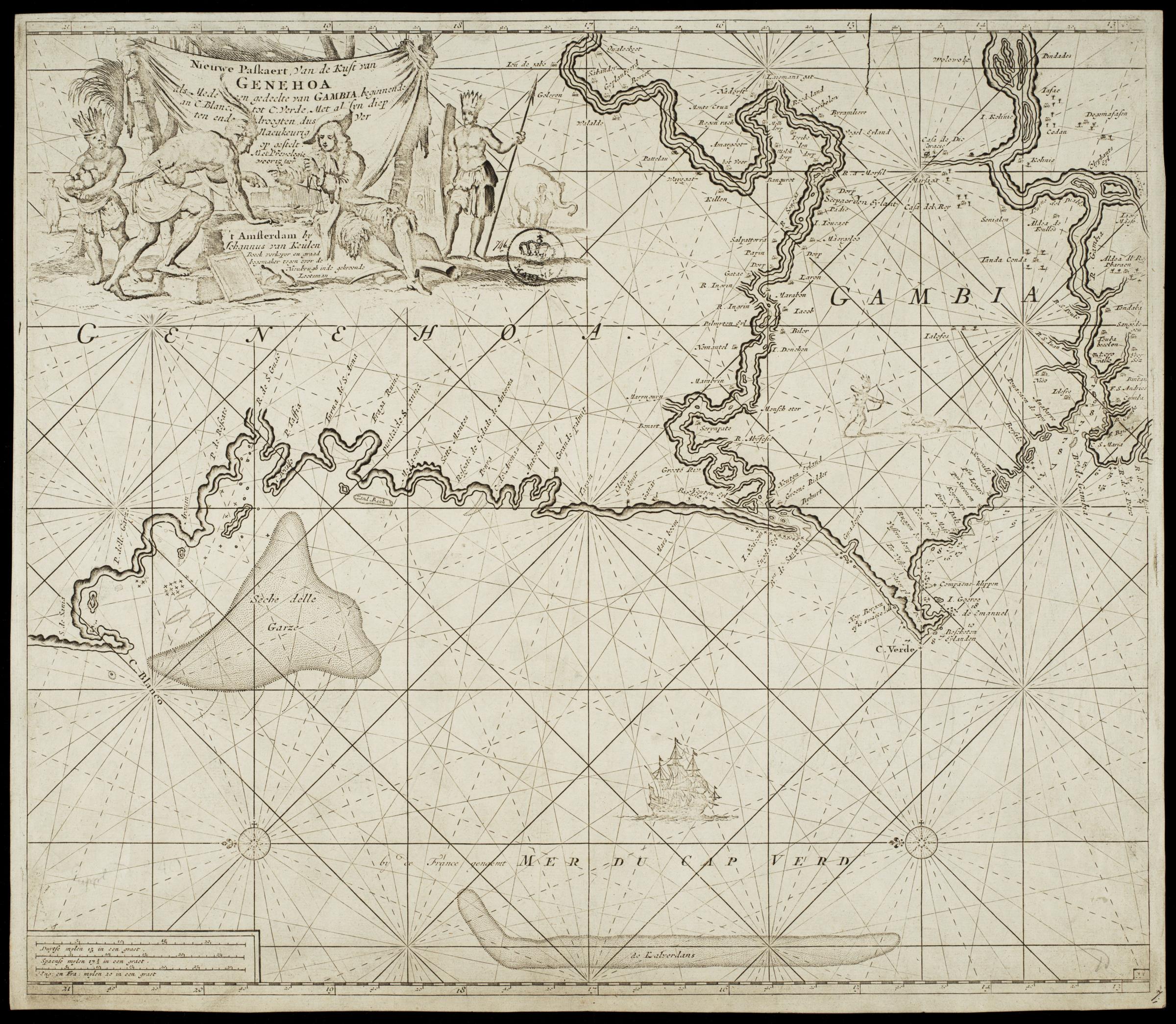
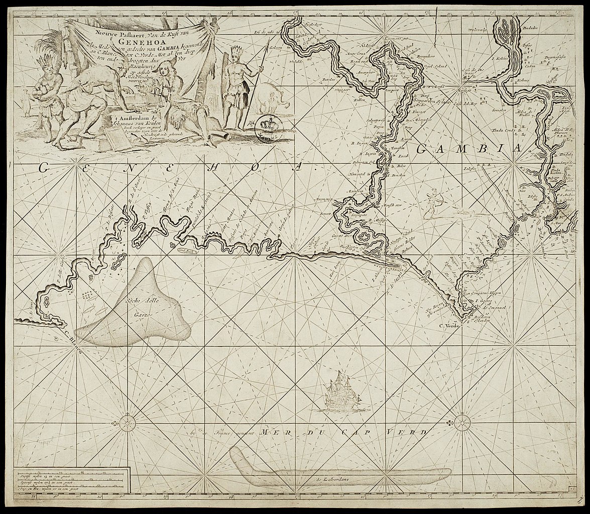
[edit]Nederlands: Kaart van de West-Afrikaanse kust, van Arguin tot Cabo Verde
English: Map of the West African coast, from Arguin to Cabo Verde( |
||||||||||||||||||||||||
|---|---|---|---|---|---|---|---|---|---|---|---|---|---|---|---|---|---|---|---|---|---|---|---|---|
| Author |
Nederlands: Johannes van Keulen (uitgever), Anoniem / Anonymous (landmeter / kaartenmaker)
English: Johannes van Keulen (publisher), Anoniem / Anonymous (land surveyor / mapmaker) |
|||||||||||||||||||||||
| Title |
Nederlands: Kaart van de West-Afrikaanse kust, van Arguin tot Cabo Verde
English: Map of the West African coast, from Arguin to Cabo Verde |
|||||||||||||||||||||||
| Description |
Nederlands: Kaart van de West-Afrikaanse kust, van Arguin tot Cabo Verde.
Titel catalogus Leupe (NA): Nieuwe paskaert Van de Kust van Genehoa alsmede een gedeelte van Gambia beginnende van C. Blanco tot C. Verde, Met al sijn diepten ende droogten dus seer Naeukeurig opgestelt. Nieuwe Paskaert Van de Kust van Genehoa als mede een gedeelte van Gambia beginnende van C. Blanco tot C. Verde, Met al syn diep ten ende droogten dus Ver Naeukeurig opgestelt. Rechtsonder: 7. Met stempeltje Marine en links daarvan het getal 746. Uitgegeven bij Johannes van Keulen. De kaart is op blauw papier geplakt. Notities verso: No. 8 / 5 [op klein etiketje] / 10.English: Map of the West African coast, from Arguin to Cabo Verde.
Title in the Leupe catalogue (NA): Nieuwe paskaert Van de Kust van Genehoa alsmede een gedeelte van Gambia beginnende van C. Blanco tot C. Verde, Met al sijn diepten ende droogten dus seer Naeukeurig opgestelt. Nieuwe Paskaert Van de Kust van Genehoa als mede een gedeelte van Gambia beginnende van C. Blanco tot C. Verde, Met al syn diep ten ende droogten dus Ver Naeukeurig opgestelt. Bottom right: 7. Bears the stamp Marine and to the left of the stamp the number 746. Published by Johannes van Keulen. The chart has been pasted onto blue paper. Notes on reverse: No. 8. / 5 [on a small label] / 10. |
|||||||||||||||||||||||
| Date | between 1650 and 1700 | |||||||||||||||||||||||
| Medium |
Nederlands: koperdruk op papier
English: copperplate printing on paper |
|||||||||||||||||||||||
| Dimensions | height: 59 cm (23.2 in); width: 51.5 cm (20.2 in) | |||||||||||||||||||||||
| Collection |
|
|||||||||||||||||||||||
| Accession number |
NL-HaNA_4.VELH_84 (old number: VELH0084) |
|||||||||||||||||||||||
| Inscriptions |
Nieuwe Paskaert Van de Kust van Genehoa als mede een gedeelte van Gambia beginnende van C. Blanco tot C. Verde, Met al syn diep ten ende droogten dus Ver Naeukeurig opgestelt
author: met Prevelegie voor 15 jaar 't Amsterdam by Johannus van Keulen Boek verkoper en graad bogemaker tegen over de Nieubrugh inde gekroonde Lootsman |
|||||||||||||||||||||||
| Notes |
English: Subjects: chart / map / plan, banderole / cartouche / ornamentation, compass / dial, Person, European, Asians & Africans, fauna, ship / vessel
Nederlands: Onderwerpen: plattegrond / kaart, banderol / cartouche / versiering, kompas / windroos, Persoon, Europeanen, Aziaten & Afrikanen, fauna, schip / vaartuig
English: Post: this image is related to a WIC trading post called Arguin |
|||||||||||||||||||||||
| Source/Photographer |
|
|||||||||||||||||||||||
| Permission (Reusing this file) |
|
|||||||||||||||||||||||

| Object location | | View this and other nearby images on: OpenStreetMap |
|---|
File history
Click on a date/time to view the file as it appeared at that time.
| Date/Time | Thumbnail | Dimensions | User | Comment | |
|---|---|---|---|---|---|
| current | 10:17, 11 June 2014 | | 2,400 × 2,091 (968 KB) | HuskyBot (talk | contribs) | == {{int:filedesc}} == {{Artwork |title = {{nl|1=Kaart van de West-Afrikaanse kust, van Arguin tot Cabo Verde}} {{en|1=Map of the West African coast, from Arguin to Cabo Verde}} |description = {{nl|1=Kaart van... |
You cannot overwrite this file.
File usage on Commons
The following page uses this file: