File:AMH-5455-NA Plan of the Orange bastion at Batavia.jpg

Original file (2,400 × 1,788 pixels, file size: 365 KB, MIME type: image/jpeg)
Captions
Captions
Summary
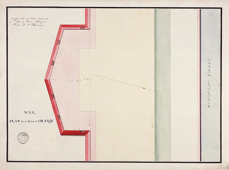
[edit]| Nederlands: Plan van het bolwerk Oranje te Batavia
English: Plan of the Orange bastion at Batavia Bahasa Indonesia: Rencana pembangunan benteng Oranye di Batavia ( |
||||||||||||||||||||||||
|---|---|---|---|---|---|---|---|---|---|---|---|---|---|---|---|---|---|---|---|---|---|---|---|---|
| Author |
Nederlands: Carl Friedrich Reimer (gewerkt naar), J.J. Hornung (landmeter / kaartenmaker)
English: Carl Friedrich Reimer (copied after), J.J. Hornung (land surveyor / mapmaker) |
|||||||||||||||||||||||
| Title |
Nederlands: Plan van het bolwerk Oranje te Batavia
English: Plan of the Orange bastion at Batavia
Bahasa Indonesia: Rencana pembangunan benteng Oranye di Batavia |
|||||||||||||||||||||||
| Description |
Nederlands: Titel catalogus Leupe (NA): Plans van de verschillende bolwerken van de stad; van verschillende grootte en afmetingen.
No. XV het bolwerk Oranje. Notities verso: 8. M. / 620 [in potlood]. Serie VEL1204A t/m VEL1204V.English: Title in the Leupe catalogue (NA): Plans van de verschillende bolwerken van de stad; van verschillende grootte en afmetingen.
No. XV the Oranje bastion. Notes on reverse: 8. M. / 620 [in pencil]. Series VEL1204A through VEL1204V.Bahasa Indonesia: Judul dalam katalog Leupe (AN): Plans van de verschillende bolwerken van de stad; van verschillende grootte en afmetingen.
No. XV benteng Oranye. Catatan di belakang: 8. M. / 620 [dengan pensil]. Seri VEL1204A sampai dengan VEL1204V. |
|||||||||||||||||||||||
| Date | circa 1762 | |||||||||||||||||||||||
| Medium |
Nederlands: ingekleurde tekening op papier
English: coloured drawing on paper
Bahasa Indonesia: gambar berwarna di atas kertas |
|||||||||||||||||||||||
| Dimensions | height: 48.5 cm (19 in); width: 36 cm (14.1 in) | |||||||||||||||||||||||
| Collection |
|
|||||||||||||||||||||||
| Accession number |
NL-HaNA_4.VEL_1204U (old number: VEL1204U) |
|||||||||||||||||||||||
| Inscriptions |
No. XV, plam van 't bolwerk Oranje.
author: gekopieert na het orgineel van de heer Reimer door J.M. Hornung |
|||||||||||||||||||||||
| Notes |
English: Subjects: cross-section / profile, fortification, chart / map / plan
Nederlands: Onderwerpen: doorsnede / profiel, vesting, plattegrond / kaart
English: Fort: this image is related to a VOC fort called kasteel Batavia |
|||||||||||||||||||||||
| Source/Photographer |
|
|||||||||||||||||||||||
| Permission (Reusing this file) |
|
|||||||||||||||||||||||

| Object location | | View this and other nearby images on: OpenStreetMap |
|---|
File history
Click on a date/time to view the file as it appeared at that time.
| Date/Time | Thumbnail | Dimensions | User | Comment | |
|---|---|---|---|---|---|
| current | 18:23, 10 June 2014 | | 2,400 × 1,788 (365 KB) | HuskyBot (talk | contribs) | == {{int:filedesc}} == {{Artwork |title = {{nl|1=Plan van het bolwerk Oranje te Batavia}} {{en|1=Plan of the Orange bastion at Batavia}} |description = {{nl|1=Titel catalogus Leupe (NA): ''Plans van de verschil... |
You cannot overwrite this file.
File usage on Commons
The following page uses this file:
File usage on other wikis
The following other wikis use this file:
- Usage on en.wikipedia.org