File:2022 New York gubernatorial election results map by county.svg
Jump to navigation
Jump to search

Size of this PNG preview of this SVG file: 782 × 600 pixels. Other resolutions: 313 × 240 pixels | 626 × 480 pixels | 1,002 × 768 pixels | 1,280 × 981 pixels | 2,560 × 1,963 pixels | 810 × 621 pixels.
Original file (SVG file, nominally 810 × 621 pixels, file size: 67 KB)
Captions
Captions
Add a one-line explanation of what this file represents
Summary
[edit]
| Description |
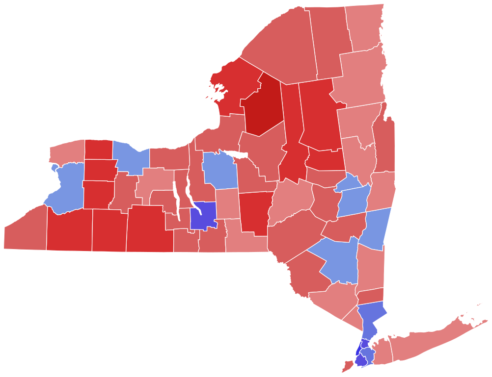
English: Map depicting the 2022 New York gubernatorial election results by counties between Kathy Hochul (D) and Lee Zeldin (R). |
| Date | |
| Source | Own work |
| Author | Sponge12345678 |
Licensing
[edit]
I, the copyright holder of this work, hereby publish it under the following license:
This file is licensed under the Creative Commons Attribution-Share Alike 4.0 International license.
- You are free:
- to share – to copy, distribute and transmit the work
- to remix – to adapt the work
- Under the following conditions:
- attribution – You must give appropriate credit, provide a link to the license, and indicate if changes were made. You may do so in any reasonable manner, but not in any way that suggests the licensor endorses you or your use.
- share alike – If you remix, transform, or build upon the material, you must distribute your contributions under the same or compatible license as the original.
File history
Click on a date/time to view the file as it appeared at that time.
| Date/Time | Thumbnail | Dimensions | User | Comment | |
|---|---|---|---|---|---|
| current | 23:37, 14 February 2024 | | 810 × 621 (67 KB) | Putitonamap98 (talk | contribs) | shapes |
| 16:32, 28 June 2023 |  | 744 × 577 (297 KB) | Gordfather69 (talk | contribs) | Reverted to version as of 06:51, 22 June 2023 (UTC) | |
| 16:03, 26 June 2023 |  | 2,835 × 2,126 (720 KB) | Alexcs114 (talk | contribs) | Reverted to version as of 15:01, 17 June 2023 (UTC) No reason not to clip the map to shoreline, as it shows the counties in their true form. County boundaries haven't been changed at all, what's the issue? | |
| 06:51, 22 June 2023 |  | 744 × 577 (297 KB) | Putitonamap98 (talk | contribs) | Reverted to version as of 12:57, 5 March 2023 (UTC) these are the standard shapes and colors | |
| 15:01, 17 June 2023 |  | 2,835 × 2,126 (720 KB) | Alexcs114 (talk | contribs) | fixed transparency | |
| 15:00, 17 June 2023 |  | 2,835 × 2,126 (721 KB) | Alexcs114 (talk | contribs) | Clipped to coastline w/ different color scheme | |
| 12:57, 5 March 2023 |  | 744 × 577 (297 KB) | Putitonamap98 (talk | contribs) | standard shapes | |
| 15:33, 10 November 2022 |  | 1,050 × 800 (322 KB) | AfroSocDem (talk | contribs) | Added a map that was more consistent with maps used on the page | |
| 19:33, 9 November 2022 |  | 512 × 404 (17 KB) | Sponge12345678 (talk | contribs) | Uploaded while editing "2022 New York gubernatorial election" on en.wikipedia.org |
You cannot overwrite this file.
File usage on Commons
The following 5 pages use this file:
File usage on other wikis
The following other wikis use this file:
- Usage on en.wikipedia.org
- Usage on fr.wikipedia.org
- Usage on zh.wikipedia.org