File:2015 Burg Gaillenreuth 02.jpg
Jump to navigation
Jump to search

Size of this preview: 418 × 599 pixels. Other resolutions: 167 × 240 pixels | 335 × 480 pixels | 535 × 768 pixels | 714 × 1,024 pixels | 1,428 × 2,048 pixels | 2,977 × 4,269 pixels.
Original file (2,977 × 4,269 pixels, file size: 3.51 MB, MIME type: image/jpeg)
Captions
Captions
Add a one-line explanation of what this file represents
Summary
[edit]
| Description |
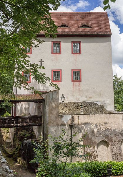
Deutsch: Burg Gaillenreuth, Mit Wohnturm, Teilen der ehemaligen Befestigung und Gräben sowie ehemalige Vorburg mit Jagdhaus und Stadel; Wohnturm (sogenannte vordere Kemenate) mehrgeschossiger verputzter Massivbau mit einseitig halbrund abgewalmtem Satteldach, im Kern 13./14. Jahrhundert, Renovierungen nach 1525, nach 1632, erste Hälfte 19. Jahrhundert; Graben und Befestigungsmauern und Kelleranlage, Naturstein 13. bis 16. Jahrhundert; ehemaliges Jägerhaus, jetzt Gasthaus, zum Graben drei-, sonst zweigeschossiger Bau, Massiv mit zweitem Obergeschoss in Fachwerk um 1600, angefügter Südostflügel mit historistischem Fachwerkobergeschoss um 1900, über älterem massivem Erdgeschoss, gemeinsames Walmdach, wohl 1920er Jahre; Scheune, Fachwerkbau mit rückwärtig abgewalmtem Satteldach, 18. Jahrhundert, Nebengebäude, erdgeschossiger Satteldachbau mit Satteldach, massiv, verputzt, 18. Jahrhundert This is a photograph of an architectural monument. It is on the list of cultural monuments of Bayern, no. D-4-74-121-64. |
| Date | |
| Source | Own work |
| Author | Derzno |
| Camera location | | View this and other nearby images on: OpenStreetMap |
|---|
Licensing
[edit]
I, the copyright holder of this work, hereby publish it under the following license:
This file is licensed under the Creative Commons Attribution-Share Alike 4.0 International license.
- You are free:
- to share – to copy, distribute and transmit the work
- to remix – to adapt the work
- Under the following conditions:
- attribution – You must give appropriate credit, provide a link to the license, and indicate if changes were made. You may do so in any reasonable manner, but not in any way that suggests the licensor endorses you or your use.
- share alike – If you remix, transform, or build upon the material, you must distribute your contributions under the same or compatible license as the original.

|
This image was uploaded as part of Wiki Loves Monuments 2016.
|
File history
Click on a date/time to view the file as it appeared at that time.
| Date/Time | Thumbnail | Dimensions | User | Comment | |
|---|---|---|---|---|---|
| current | 05:35, 21 September 2016 | | 2,977 × 4,269 (3.51 MB) | Derzno (talk | contribs) | User created page with UploadWizard |
You cannot overwrite this file.
File usage on Commons
There are no pages that use this file.
File usage on other wikis
The following other wikis use this file:
- Usage on de.wikipedia.org
- Usage on www.wikidata.org