File:2011 Welsh Devolution Referendum results map.PNG
Jump to navigation
Jump to search

Size of this preview: 499 × 599 pixels. Other resolutions: 200 × 240 pixels | 399 × 480 pixels | 639 × 768 pixels | 1,043 × 1,253 pixels.
Original file (1,043 × 1,253 pixels, file size: 151 KB, MIME type: image/png)
Captions
Captions
Add a one-line explanation of what this file represents

|
File:Welsh devolution referendum, 2011.svg is a vector version of this file. It should be used in place of this PNG file.
File:2011 Welsh Devolution Referendum results map.PNG → File:Welsh devolution referendum, 2011.svg
For more information, see Help:SVG. |
 |
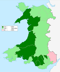
| Description | Map of the results of the Welsh Devolution Rferendum 2011. |
| Date | (UTC) |
| Source | |
| Author |
|
| This is a retouched picture, which means that it has been digitally altered from its original version. Modifications: Changed colours. The original can be viewed here: Wales Powys locator map.svg:
|
I, the copyright holder of this work, hereby publish it under the following license:
This file is licensed under the Creative Commons Attribution-Share Alike 3.0 Unported license.
- You are free:
- to share – to copy, distribute and transmit the work
- to remix – to adapt the work
- Under the following conditions:
- attribution – You must give appropriate credit, provide a link to the license, and indicate if changes were made. You may do so in any reasonable manner, but not in any way that suggests the licensor endorses you or your use.
- share alike – If you remix, transform, or build upon the material, you must distribute your contributions under the same or compatible license as the original.
Original upload log
[edit]
This image is a derivative work of the following images:
- File:Wales_Powys_locator_map.svg licensed with Cc-by-sa-3.0
- 2010-05-04T18:57:05Z NordNordWest 1047x1251 (156753 Bytes) {{int:filedesc}} {{Information |Description= {{de|Lagekarte von Powys in Wales}} {{en|Locator map of Powys in Wales}} |Source={{Own}} |Date=2010-05-04 |Author={{U|NordNordWest}} |Permission={{self|cc-by-sa-3.0}} |other_versi
Uploaded with derivativeFX
File history
Click on a date/time to view the file as it appeared at that time.
| Date/Time | Thumbnail | Dimensions | User | Comment | |
|---|---|---|---|---|---|
| current | 15:49, 4 March 2011 | | 1,043 × 1,253 (151 KB) | Delusion23 (talk | contribs) | {{Information |Description=Map of the results of the Welsh Devolution Rferendum 2011. |Source=*File:Wales_Powys_locator_map.svg |Date=2011-03-04 15:49 (UTC) |Author=*File:Wales_Powys_locator_map.svg: {{U|NordNordWest}} *derivative work: ~~~ |P |
You cannot overwrite this file.
File usage on Commons
There are no pages that use this file.
File usage on other wikis
The following other wikis use this file:
- Usage on cy.wikipedia.org
- Usage on en.wikipedia.org