File:2010 Chile earthquake - Building destroyed in Concepción.jpg
Jump to navigation
Jump to search

Size of this preview: 800 × 534 pixels. Other resolutions: 320 × 213 pixels | 640 × 427 pixels | 1,024 × 683 pixels.
Original file (1,024 × 683 pixels, file size: 525 KB, MIME type: image/jpeg)
Captions
Captions
Add a one-line explanation of what this file represents
Summary
[edit]| Description |
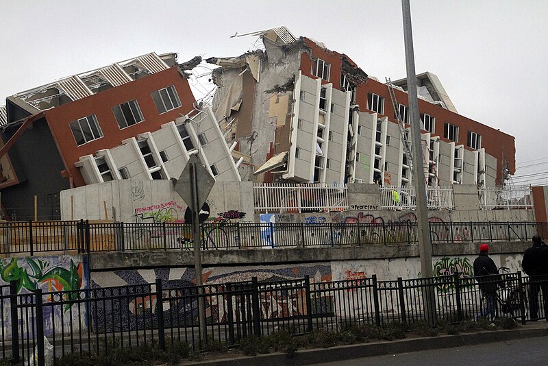
Español: En Concepción, el edificio Alto Río, de 20 pisos, colapsó producto del terremoto del 27 de febrero de 2010. |
||
| Date | |||
| Source | originally posted to Flickr as _MG_3277 | ||
| Author | Claudio Núñez | ||
| Permission (Reusing this file) |
This file is licensed under the Creative Commons Attribution-Share Alike 2.0 Generic license.
|
||
| Other versions |
.jpg)
File history
Click on a date/time to view the file as it appeared at that time.
| Date/Time | Thumbnail | Dimensions | User | Comment | |
|---|---|---|---|---|---|
| current | 00:49, 9 March 2010 | | 1,024 × 683 (525 KB) | Cantus (talk | contribs) | fix tone |
| 05:16, 3 March 2010 |  | 1,024 × 683 (359 KB) | Flickr upload bot (talk | contribs) | Uploaded from http://flickr.com/photo/62237714@N00/4403283810 using Flickr upload bot |
You cannot overwrite this file.
File usage on Commons
The following 5 pages use this file:
File usage on other wikis
The following other wikis use this file:
- Usage on ast.wikipedia.org
- Usage on be.wikipedia.org
- Usage on bg.wikipedia.org
- Usage on bn.wikipedia.org
- Usage on ca.wikipedia.org
- Usage on ckb.wikipedia.org
- Usage on cs.wikipedia.org
- Usage on cy.wikipedia.org
- Usage on en.wikipedia.org
- Talk:Plate tectonics
- Talk:Age of Earth
- Talk:Tsunami
- Talk:Intraplate earthquake
- Talk:Seismic hazard
- Talk:Earthquake preparedness
- Talk:Earthquake prediction
- Talk:Urban seismic risk
- Talk:Seismometer
- Talk:Earthquake construction
- Talk:Blind thrust earthquake
- Talk:1989 Loma Prieta earthquake
- Talk:Seismic wave
- Talk:1931 Hawke's Bay earthquake
- Talk:Fault (geology)
- Talk:1872 Owens Valley earthquake
- Talk:Lists of earthquakes
- Talk:1755 Lisbon earthquake
- Talk:List of tectonic plates
- Talk:Eurasian Plate
- Talk:Japan Meteorological Agency seismic intensity scale
- Talk:2001 Nisqually earthquake
- Talk:Moment magnitude scale
- Talk:Hayward Fault Zone
- Talk:1923 Great Kantō earthquake
- Talk:San Andreas Fault
- Talk:Induced seismicity
- Talk:New Madrid Seismic Zone
- Talk:2004 Chūetsu earthquake
- Talk:Infrasound
- Talk:Parkfield earthquake
- Talk:Great Hanshin earthquake
- Talk:2001 Gujarat earthquake
- Talk:Ring of Fire
- Talk:Seismic moment
- Talk:2004 Indian Ocean earthquake and tsunami
- Talk:1960 Valdivia earthquake
View more global usage of this file.