File:20080929-laura-full.jpg

Original file (6,431 × 7,806 pixels, file size: 34.11 MB, MIME type: image/jpeg)
Captions
Captions
Summary
[edit]| Description20080929-laura-full.jpg |
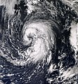
English: In late September, a large non-tropical system located over the north-central Atlantic slowly moved westward away from the Azores. The low produced hurricane-force winds, but did not exhibit the characteristics of a tropical cyclone. The storm steadily weakened over the following days, but developed tropical characteristics as it moved over slightly warmer waters.
By September 29, the low had developed sufficient convection and was declared Subtropical Storm Laura. Upon being upgraded, cold cloud tops began to wrap around the center of Laura and consolidate near the center of circulation. The convection organized around the center quickly and a satellite pass over the storm revealed that it could be intensifying. A later satellite pass disregarded the possibility of intensification as the intensity was confirmed to be at 60 mph (95 km/h). The overall structure of Laura remained subtropical but there were indications that it might have been acquiring tropical characteristics. As of 11 p.m. AST September 29 (0300 UTC September 30), Subtropical Storm Laura is located within 20 nautical miles of 38.3°N 48.4°W, about 585 mi (940 km) south-southeast of Cape Race, Newfoundland and Labrador. Maximum sustained winds are 50 knots (60 mph, 95 km/h), with stronger gusts. Minimum central pressure is 995 mbar (hPa; 29.38 InHg), and the system is moving north at 8 kt (9 mph, 15 km/h). |
| Date | |
| Source | NASA Worldview |
| Author | NASA |
| Permission (Reusing this file) |
Public domain |
Licensing
[edit]| Public domainPublic domainfalsefalse |
| This file is in the public domain in the United States because it was solely created by NASA. NASA copyright policy states that "NASA material is not protected by copyright unless noted". (See Template:PD-USGov, NASA copyright policy page or JPL Image Use Policy.) |  | |
 |
Warnings:
|
File history
Click on a date/time to view the file as it appeared at that time.
| Date/Time | Thumbnail | Dimensions | User | Comment | |
|---|---|---|---|---|---|
| current | 11:31, 2 April 2013 |  | 6,431 × 7,806 (34.11 MB) | Supportstorm (talk | contribs) | Geo-rectify |
| 05:51, 26 March 2013 |  | 7,329 × 7,915 (11.07 MB) | Earth100 (talk | contribs) | 250 meter res, better quality. |
You cannot overwrite this file.
File usage on Commons
The following page uses this file:
File usage on other wikis
The following other wikis use this file:
- Usage on de.wikipedia.org
- Usage on en.wikipedia.org
- Usage on es.wikipedia.org
- Usage on eu.wikipedia.org
- Usage on ko.wikipedia.org
- Usage on pt.wikipedia.org
- Usage on ru.wikipedia.org
- Usage on uk.wikipedia.org
- Usage on www.wikidata.org
- Usage on zh.wikipedia.org
Metadata
This file contains additional information such as Exif metadata which may have been added by the digital camera, scanner, or software program used to create or digitize it. If the file has been modified from its original state, some details such as the timestamp may not fully reflect those of the original file. The timestamp is only as accurate as the clock in the camera, and it may be completely wrong.
| Width | 17,314 px |
|---|---|
| Height | 17,341 px |
| Bits per component |
|
| Compression scheme | Uncompressed |
| Pixel composition | RGB |
| Orientation | Normal |
| Number of components | 3 |
| Horizontal resolution | 72 dpi |
| Vertical resolution | 72 dpi |
| Data arrangement | chunky format |
| Software used | Adobe Photoshop CS4 Windows |
| File change date and time | 06:27, 2 April 2013 |
| Color space | Uncalibrated |
| Image width | 6,431 px |
| Image height | 7,806 px |
| Date and time of digitizing | 01:08, 2 April 2013 |
| Date metadata was last modified | 01:27, 2 April 2013 |
| Unique ID of original document | xmp.did:027BA220CB99E211B1F5F58C7F171408 |