File:1932 Chinese Map of Tientsin (Tianjin or Tienjin), China - Geographicus - Tienjin-showa7-1932.jpg
Jump to navigation
Jump to search
Size of this preview: 403 × 599 pixels. Other resolutions: 161 × 240 pixels | 323 × 480 pixels | 516 × 768 pixels | 689 × 1,024 pixels | 1,377 × 2,048 pixels | 3,000 × 4,460 pixels.
Original file (3,000 × 4,460 pixels, file size: 3.22 MB, MIME type: image/jpeg)
Captions
Captions
Add a one-line explanation of what this file represents
| Tientsin. | ||||||
|---|---|---|---|---|---|---|
| Artist | ||||||
| Title |
Tientsin. |
|||||
| Description |
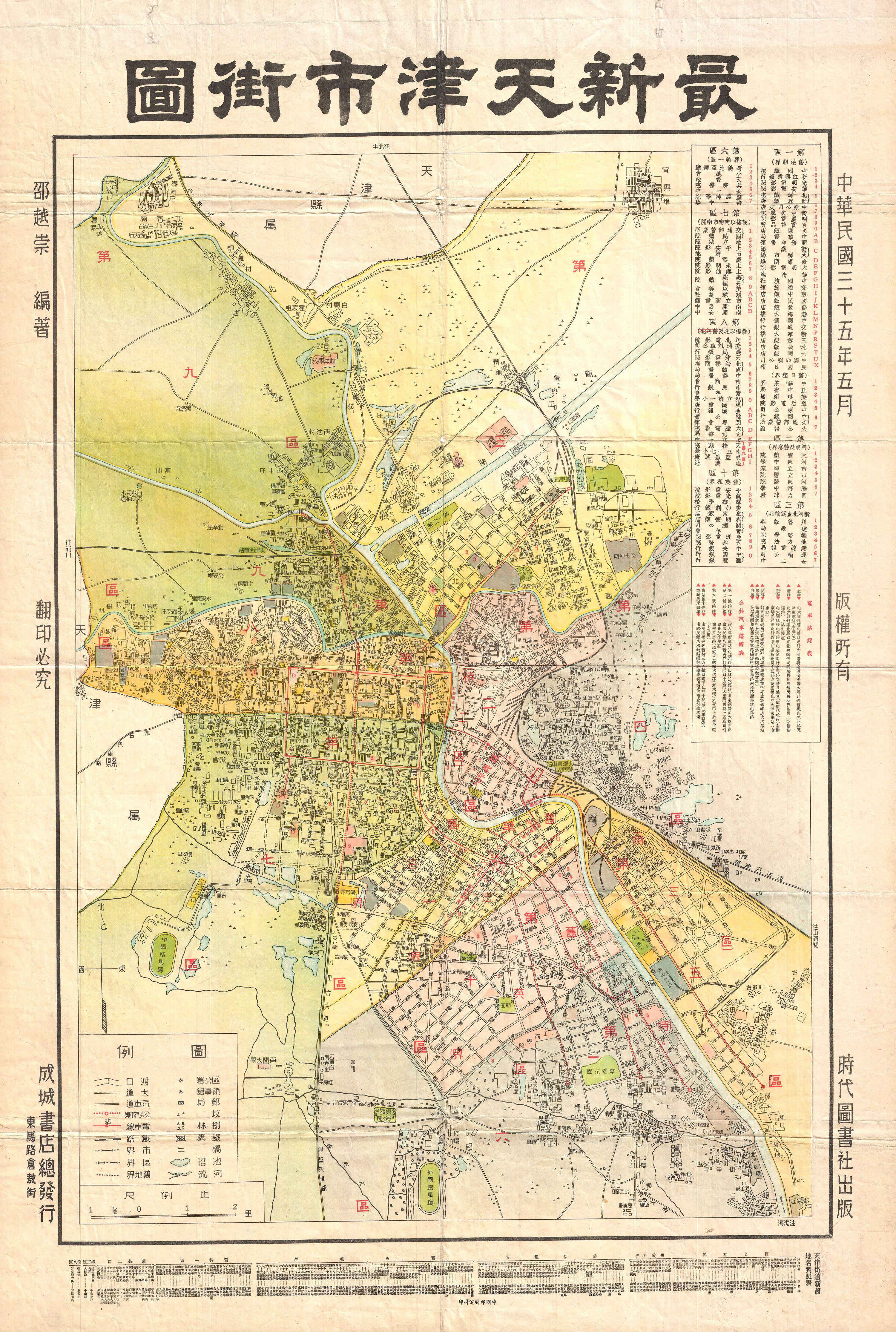
English: A highly uncommon map of Tianjin (Chinese: ??; pinyin: Tianjin; Wade-Giles: T'ien-chin; [t?i??n?? t??in??]; Postal map spelling: Tientsin), China dating to 1932. Tientsin was a major trading center in Northern China and, like Shanghai, had administrative concessions to several foreign nations including England, Italy, France, Austria-Hungary, Belgium, Japan, Germany and Russia. Curiously none of the foreign concessions are noted on this map, suggesting it was issued by an isolationist anti-trade element. It does however identify streets, rail lines, administrative buildings, parks, and public centers. All text in Chinese. |
|||||
| Date | 1932 (dated) | |||||
| Dimensions | height: 29 in (73.6 cm); width: 20 in (50.8 cm) | |||||
| Accession number |
Geographicus link: Tienjin-showa7-1932 |
|||||
| Source/Photographer |
|
|||||
| Permission (Reusing this file) |
|
|||||
File history
Click on a date/time to view the file as it appeared at that time.
| Date/Time | Thumbnail | Dimensions | User | Comment | |
|---|---|---|---|---|---|
| current | 12:30, 24 March 2011 | | 3,000 × 4,460 (3.22 MB) | BotMultichillT (talk | contribs) | {{subst:User:Multichill/Geographicus |link=http://www.geographicus.com/P/AntiqueMap/Tienjin-showa7-1932 |product_name=1932 Chinese Map of Tientsin (Tianjin or Tienjin), China |map_title=Tientsin. |description=A highly uncommon map of Tianjin (Chinese: ??; |
You cannot overwrite this file.
File usage on Commons
The following 2 pages use this file:
,_China_-_Geographicus_-_Tienjin-showa7-1932.jpg)
,_China_-_Geographicus_-_Tienjin-showa7-1932.jpg&oldid=905554847)